Zhovti Vody elevation
Zhovti Vody (Dnipropetrovsk), Ukraine elevation is 151 meters and Zhovti Vody elevation in feet is 495 ft above sea level [src 1]. Zhovti Vody is a populated place (feature code) with elevation that is 6 meters (20 ft) smaller than average city elevation in Ukraine.
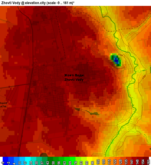
Below is the Elevation map of Zhovti Vody, which displays elevation range with different colors. Scale of the first map is from -9 to 161 m (-30 to 528 ft) with average elevation of 133.7 meters (=439 ft) [note 1]
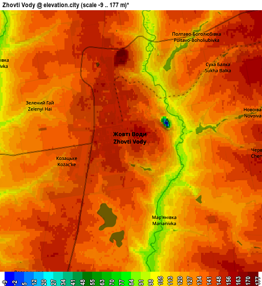
These maps also provides idea of topography and contour of this city, they are displayed at different zoom levels. More info about maps, scale and edge coordinates you can find below images.
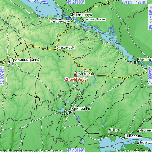
| \ | Map #1 | Map #2 | Topo.Map |
| Scale [m] | -9..161 m | -9..177 m | × |
| Scale [ft] | -30..528 ft | -30..581 ft | × |
| Average | 133.7 m = 439 ft | 133.6 m = 438 ft | × |
| Width | 6.5 km = 4 mi | 12.99 km = 8.1 mi | 207.9 km = 129.2 mi |
| Height | 6.5 km = 4 mi | 12.99 km = 8.1 mi | 207.8 km = 129.1 mi |
| ↑Max Latitude | 48.37413° | 48.403313° | 49.27103° |
| Latitude at center | 48.34493° | 48.34493° | 48.34493° |
| ↓Min Latitude | 48.315714° | 48.28648° | 47.40169° |
| ← Min Longitude | 33.459795° | 33.415849° | 32.09749° |
| Longitude center | 33.50374° | 33.50374° | 33.50374° |
| →Max Longitude | 33.547685° | 33.591631° | 34.90999° |
Nearby cities:
Cities around Zhovti Vody sort by population:
• Kryvyi Rih elevation 99 m
49.3 km,  190°
190°
• Oleksandriya 106 m
46 km,  321°
321°
• Piatykhatky 169 m
17.1 km,  63°
63°
• Petrove 104 m
18.4 km,  262°
262°
• Sofiyivka 108 m
43 km,  140°
140°
• Nova Praha 107 m
50.8 km,  299°
299°
• Lozuvatka 88 m
35.8 km,  206°
206°
• Oleksandriys’ke 145 m
48.2 km,  307°
307°
• Novyy Starodub 87 m
30.9 km, 307°
• Pryyutivka 107 m
52.6 km, 322°
• Vyshneve 125 m
32.1 km,  71°
71°
• Lykhivka 72 m
49 km,  39°
39°
Multilingual:
 En español:
Zhovti Vody elevación 151 m.
 En France:
Jovti Vody élévation 151 m.
 Auf Deutsch:
Schowti Wody höhe über dem Meeresspiegel ist 151 m.

Sources and notes:
- [note 1] Map square and city borders are not equal. Map elevation data is calculated only from area inside that square.
- [src 1] Elevation data from geonames database provided with same terms of usage.
- [src 2] The elevation map of Zhovti Vody is generated using elevation data from NASA's 3 arcsec (90m) resolution SRTM data.
- [src 3] Base (background) map © OpenStreetMap contributors tiles are generated by Geofabrik and OpenTopoMap.
Copyright & License:
This Zhovti Vody Elevation Map is licensed under CC BY-SA. You may reuse any part from this page, if you give a proper credit by linking to this URL:
 More info on terms of use page.