Lozuvatka elevation
Lozuvatka (Kirovohrad), Ukraine elevation is 88 meters and Lozuvatka elevation in feet is 289 ft above sea level [src 1]. Lozuvatka is a populated place (feature code) with elevation that is 69 meters (226 ft) smaller than average city elevation in Ukraine.
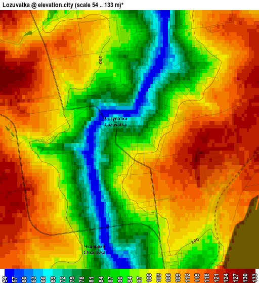
Below is the Elevation map of Lozuvatka, which displays elevation range with different colors. Scale of the first map is from 54 to 133 m (177 to 436 ft) with average elevation of 100.8 meters (=331 ft) [note 1]
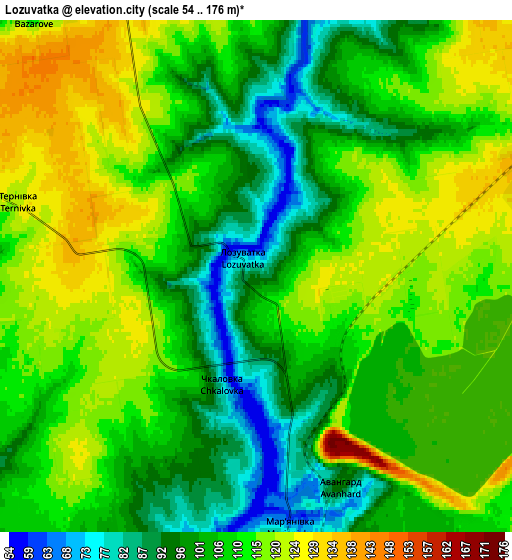
These maps also provides idea of topography and contour of this city, they are displayed at different zoom levels. More info about maps, scale and edge coordinates you can find below images.
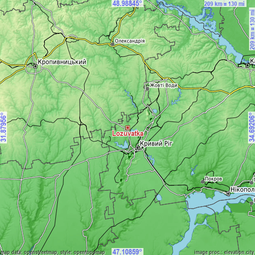
| \ | Map #1 | Map #2 | Topo.Map |
| Scale [m] | 54..133 m | 54..176 m | × |
| Scale [ft] | 177..436 ft | 177..577 ft | × |
| Average | 100.8 m = 331 ft | 108.6 m = 356 ft | × |
| Width | 6.53 km = 4.1 mi | 13.06 km = 8.1 mi | 209 km = 129.9 mi |
| Height | 6.53 km = 4.1 mi | 13.06 km = 8.1 mi | 209 km = 129.9 mi |
| ↑Max Latitude | 48.086464° | 48.115812° | 48.98845° |
| Latitude at center | 48.0571° | 48.0571° | 48.0571° |
| ↓Min Latitude | 48.027719° | 47.998321° | 47.10859° |
| ← Min Longitude | 33.241865° | 33.197919° | 31.87956° |
| Longitude center | 33.28581° | 33.28581° | 33.28581° |
| →Max Longitude | 33.329755° | 33.373701° | 34.69206° |
Nearby cities:
Cities around Lozuvatka sort by population:
• Kryvyi Rih elevation 99 m
17.8 km,  156°
156°
• Zhovti Vody 151 m
35.8 km,  26°
26°
• Dolyns'ka 193 m
39.2 km,  278°
278°
• Piatykhatky 169 m
50.6 km,  38°
38°
• Apostolove 87 m
54.5 km,  144°
144°
• Shyroke 29 m
40.7 km,  183°
183°
• Petrove 104 m
29.8 km,  355°
355°
• Sofiyivka 108 m
43.9 km,  91°
91°
• Kazanka 92 m
41.8 km,  235°
235°
• Novyy Starodub 87 m
51.7 km,  350°
350°
• Ustynivka 84 m
56.9 km,  258°
258°
• Molodizhne 154 m
48.3 km,  286°
286°
Multilingual:
 En español:
Lozuvatka elevación 88 m.
 En France:
Lozuvatka élévation 88 m.
 Auf Deutsch:
Lozuvatka höhe über dem Meeresspiegel ist 88 m.

Sources and notes:
- [note 1] Map square and city borders are not equal. Map elevation data is calculated only from area inside that square.
- [src 1] Elevation data from geonames database provided with same terms of usage.
- [src 2] The elevation map of Lozuvatka is generated using elevation data from NASA's 3 arcsec (90m) resolution SRTM data.
- [src 3] Base (background) map © OpenStreetMap contributors tiles are generated by Geofabrik and OpenTopoMap.
Copyright & License:
This Lozuvatka Elevation Map is licensed under CC BY-SA. You may reuse any part from this page, if you give a proper credit by linking to this URL:
 More info on terms of use page.