Myhove elevation
Myhove (Chernivtsi Oblast'), Ukraine elevation is 451 meters and Myhove elevation in feet is 1480 ft above sea level [src 1]. Myhove is a populated place (feature code) with elevation that is 294 meters (965 ft) bigger than average city elevation in Ukraine.
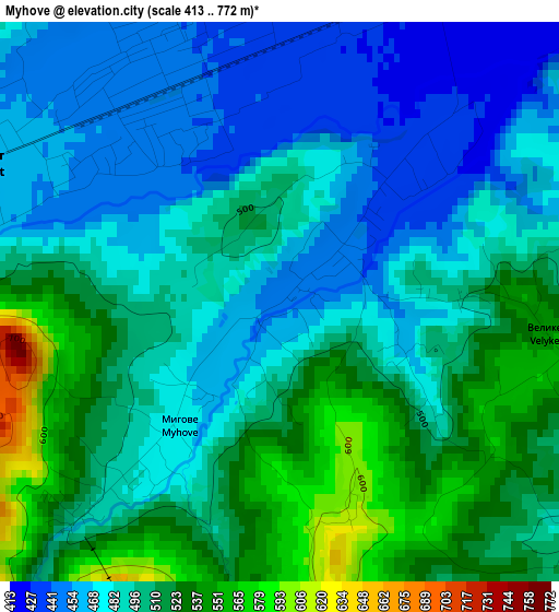
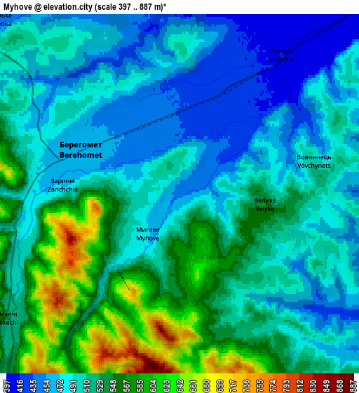
Below is the Elevation map of Myhove, which displays elevation range with different colors. Scale of the first map is from 413 to 772 m (1355 to 2533 ft) with average elevation of 495.5 meters (=1626 ft) [note 1]
These maps also provides idea of topography and contour of this city, they are displayed at different zoom levels. More info about maps, scale and edge coordinates you can find below images.
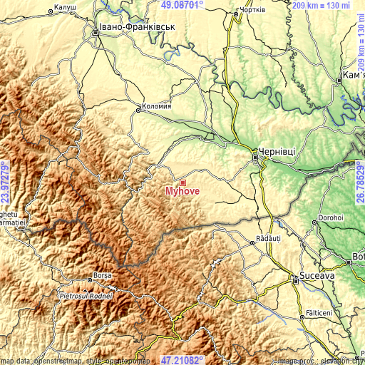
| \ | Map #1 | Map #2 | Topo.Map |
| Scale [m] | 413..772 m | 397..887 m | × |
| Scale [ft] | 1355..2533 ft | 1302..2910 ft | × |
| Average | 495.5 m = 1626 ft | 512.6 m = 1682 ft | × |
| Width | 6.52 km = 4.1 mi | 13.04 km = 8.1 mi | 208.6 km = 129.6 mi |
| Height | 6.52 km = 4.1 mi | 13.04 km = 8.1 mi | 208.6 km = 129.6 mi |
| ↑Max Latitude | 48.186797° | 48.216087° | 49.08701° |
| Latitude at center | 48.15749° | 48.15749° | 48.15749° |
| ↓Min Latitude | 48.128166° | 48.098826° | 47.21082° |
| ← Min Longitude | 25.335095° | 25.291149° | 23.97279° |
| Longitude center | 25.37904° | 25.37904° | 25.37904° |
| →Max Longitude | 25.422985° | 25.466931° | 26.78529° |
Nearby cities:
Cities around Myhove sort by population:
• Berehomet elevation 450 m
3.3 km,  316°
316°
• Kosiv 369 m
27 km,  309°
309°
• Rozhniv 282 m
25.8 km,  333°
333°
• Stari Kuty 347 m
19.8 km, 309°
• Chudey 387 m
21.5 km,  122°
122°
• Vyzhnytsya 338 m
17 km, 306°
• Ispas 323 m
17.4 km, 333°
• Kuty 328 m
18.6 km, 307°
• Banyliv 253 m
23.3 km,  353°
353°
• Yizhivtsi 371 m
24.8 km, 121°
• Davydivka 404 m
14.4 km,  106°
106°
• Storozhynets’ 368 m
25.3 km,  88°
88°
Multilingual:
 En español:
Myhove elevación 451 m.
 En France:
Myhove élévation 451 m.


Sources and notes:
- [note 1] Map square and city borders are not equal. Map elevation data is calculated only from area inside that square.
- [src 1] Elevation data from geonames database provided with same terms of usage.
- [src 2] The elevation map of Myhove is generated using elevation data from NASA's 3 arcsec (90m) resolution SRTM data.
- [src 3] Base (background) map © OpenStreetMap contributors tiles are generated by Geofabrik and OpenTopoMap.
Copyright & License:
This Myhove Elevation Map is licensed under CC BY-SA. You may reuse any part from this page, if you give a proper credit by linking to this URL:
 More info on terms of use page.