Mostys'ka elevation
Mostys'ka (Lviv), Ukraine elevation is 210 meters and Mostys'ka elevation in feet is 689 ft above sea level [src 1]. Mostys'ka is a populated place (feature code) with elevation that is 53 meters (174 ft) bigger than average city elevation in Ukraine.
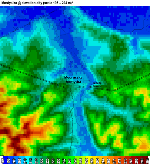
Below is the Elevation map of Mostys'ka, which displays elevation range with different colors. Scale of the first map is from 195 to 294 m (640 to 965 ft) with average elevation of 224 meters (=735 ft) [note 1]
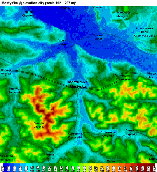
These maps also provides idea of topography and contour of this city, they are displayed at different zoom levels. More info about maps, scale and edge coordinates you can find below images.
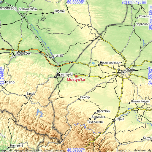
| \ | Map #1 | Map #2 | Topo.Map |
| Scale [m] | 195..294 m | 192..297 m | × |
| Scale [ft] | 640..965 ft | 630..974 ft | × |
| Average | 224 m = 735 ft | 222.4 m = 730 ft | × |
| Width | 6.31 km = 3.9 mi | 12.62 km = 7.8 mi | 201.9 km = 125.5 mi |
| Height | 6.31 km = 3.9 mi | 12.62 km = 7.8 mi | 201.9 km = 125.5 mi |
| ↑Max Latitude | 49.82303° | 49.851373° | 50.69395° |
| Latitude at center | 49.79467° | 49.79467° | 49.79467° |
| ↓Min Latitude | 49.766294° | 49.737901° | 48.87837° |
| ← Min Longitude | 23.106825° | 23.062879° | 21.74452° |
| Longitude center | 23.15077° | 23.15077° | 23.15077° |
| →Max Longitude | 23.194715° | 23.238661° | 24.55702° |
Nearby cities:
Cities around Mostys'ka sort by population:
• Sambir elevation 308 m
30.9 km,  173°
173°
• Novoyavorivs'k 297 m
33.8 km,  63°
63°
• Yavoriv 231 m
23.1 km,  46°
46°
• Sudova Vyshnya 216 m
15.9 km,  92°
92°
• Shklo 265 m
33.5 km, 57°
• Rudky 265 m
28.8 km,  123°
123°
• Murovane 326 m
34.1 km,  206°
206°
• Ralivka 296 m
33.4 km, 169°
• Voyutychi 297 m
27.2 km,  186°
186°
• Rodatychi 244 m
27.5 km, 89°
• Pnikut 233 m
9.3 km, 185°
• Skelivka 317 m
31.6 km, 205°
Multilingual:
 En español:
Mostys'ka elevación 210 m.
 En France:
Mostys'ka élévation 210 m.
 Auf Deutsch:
Mostys'ka höhe über dem Meeresspiegel ist 210 m.

Sources and notes:
- [note 1] Map square and city borders are not equal. Map elevation data is calculated only from area inside that square.
- [src 1] Elevation data from geonames database provided with same terms of usage.
- [src 2] The elevation map of Mostys'ka is generated using elevation data from NASA's 3 arcsec (90m) resolution SRTM data.
- [src 3] Base (background) map © OpenStreetMap contributors tiles are generated by Geofabrik and OpenTopoMap.
Copyright & License:
This Mostys'ka Elevation Map is licensed under CC BY-SA. You may reuse any part from this page, if you give a proper credit by linking to this URL:
 More info on terms of use page.