Ralivka elevation
Ralivka (Lviv), Ukraine elevation is 296 meters and Ralivka elevation in feet is 971 ft above sea level [src 1]. Ralivka is a populated place (feature code) with elevation that is 139 meters (456 ft) bigger than average city elevation in Ukraine.
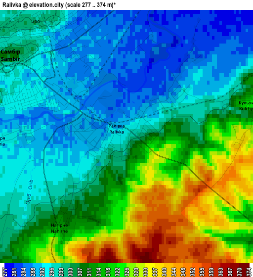
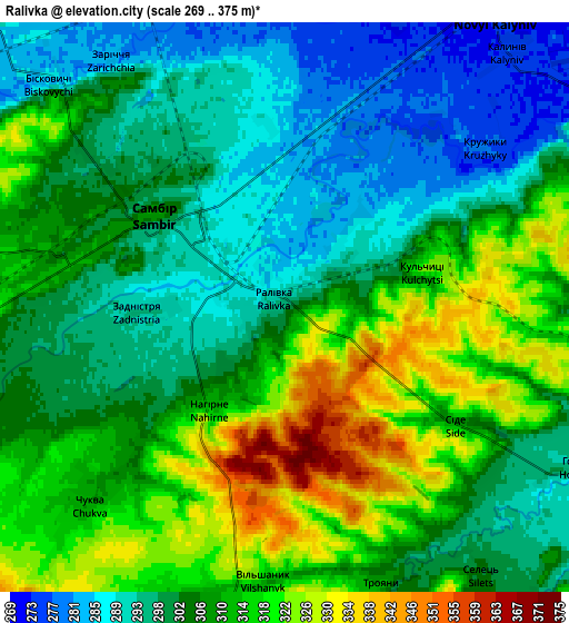
Below is the Elevation map of Ralivka, which displays elevation range with different colors. Scale of the first map is from 277 to 374 m (909 to 1227 ft) with average elevation of 307 meters (=1007 ft) [note 1]
These maps also provides idea of topography and contour of this city, they are displayed at different zoom levels. More info about maps, scale and edge coordinates you can find below images.
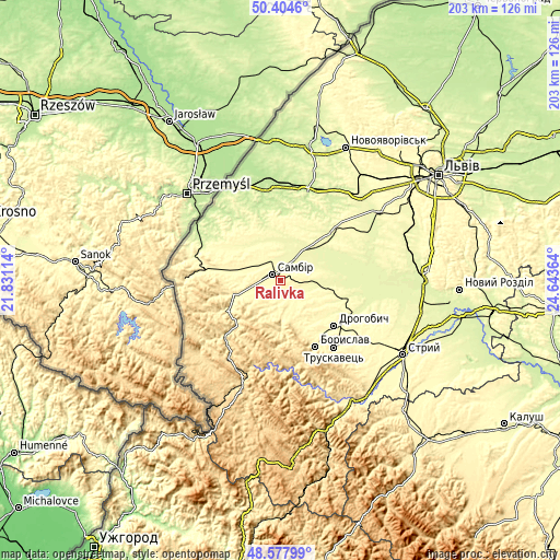
| \ | Map #1 | Map #2 | Topo.Map |
| Scale [m] | 277..374 m | 269..375 m | × |
| Scale [ft] | 909..1227 ft | 883..1230 ft | × |
| Average | 307 m = 1007 ft | 305.7 m = 1003 ft | × |
| Width | 6.35 km = 3.9 mi | 12.69 km = 7.9 mi | 203.1 km = 126.2 mi |
| Height | 6.35 km = 3.9 mi | 12.69 km = 7.9 mi | 203.1 km = 126.2 mi |
| ↑Max Latitude | 49.528352° | 49.556867° | 50.4046° |
| Latitude at center | 49.49982° | 49.49982° | 49.49982° |
| ↓Min Latitude | 49.471271° | 49.442706° | 48.57799° |
| ← Min Longitude | 23.193445° | 23.149499° | 21.83114° |
| Longitude center | 23.23739° | 23.23739° | 23.23739° |
| →Max Longitude | 23.281335° | 23.325281° | 24.64364° |
Nearby cities:
Cities around Ralivka sort by population:
• Drohobych elevation 301 m
25.6 km,  130°
130°
• Boryslav 359 m
27.6 km,  149°
149°
• Sambir 308 m
3.5 km,  305°
305°
• Staryy Sambir 348 m
18.4 km,  248°
248°
• Rudky 265 m
24.8 km,  46°
46°
• Murovane 326 m
21.8 km,  276°
276°
• Rykhtychi 293 m
26.4 km,  118°
118°
• Pidbuzh 391 m
18.4 km,  177°
177°
• Voyutychi 297 m
11.1 km,  301°
301°
• Dublyany 281 m
10.8 km,  90°
90°
• Pnikut 233 m
24.5 km,  343°
343°
• Skelivka 317 m
20.1 km, 281°
Multilingual:
 En español:
Ralivka elevación 296 m.
 En France:
Ralivka élévation 296 m.


Sources and notes:
- [note 1] Map square and city borders are not equal. Map elevation data is calculated only from area inside that square.
- [src 1] Elevation data from geonames database provided with same terms of usage.
- [src 2] The elevation map of Ralivka is generated using elevation data from NASA's 3 arcsec (90m) resolution SRTM data.
- [src 3] Base (background) map © OpenStreetMap contributors tiles are generated by Geofabrik and OpenTopoMap.
Copyright & License:
This Ralivka Elevation Map is licensed under CC BY-SA. You may reuse any part from this page, if you give a proper credit by linking to this URL:
 More info on terms of use page.