Yavoriv elevation
Yavoriv (Lviv), Ukraine elevation is 231 meters and Yavoriv elevation in feet is 758 ft above sea level [src 1]. Yavoriv is a seat of a second-order administrative division (feature code) with elevation that is 74 meters (243 ft) bigger than average city elevation in Ukraine.
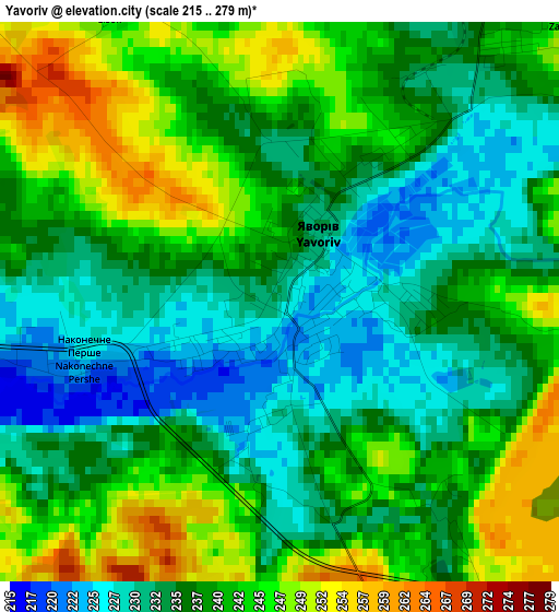
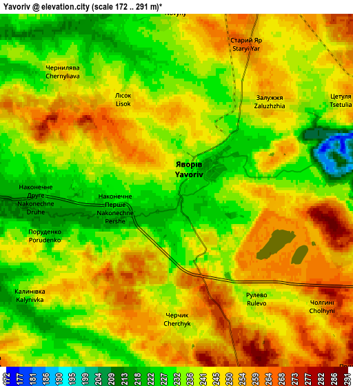
Below is the Elevation map of Yavoriv, which displays elevation range with different colors. Scale of the first map is from 215 to 279 m (705 to 915 ft) with average elevation of 238.4 meters (=782 ft) [note 1]
These maps also provides idea of topography and contour of this city, they are displayed at different zoom levels. More info about maps, scale and edge coordinates you can find below images.
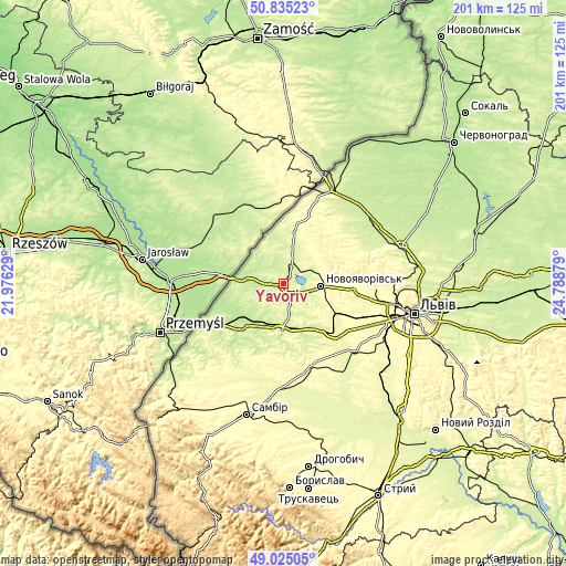
| \ | Map #1 | Map #2 | Topo.Map |
| Scale [m] | 215..279 m | 172..291 m | × |
| Scale [ft] | 705..915 ft | 564..955 ft | × |
| Average | 238.4 m = 782 ft | 241.3 m = 792 ft | × |
| Width | 6.29 km = 3.9 mi | 12.58 km = 7.8 mi | 201.3 km = 125.1 mi |
| Height | 6.29 km = 3.9 mi | 12.58 km = 7.8 mi | 201.3 km = 125.1 mi |
| ↑Max Latitude | 49.966915° | 49.995174° | 50.83523° |
| Latitude at center | 49.93864° | 49.93864° | 49.93864° |
| ↓Min Latitude | 49.910348° | 49.88204° | 49.02505° |
| ← Min Longitude | 23.338595° | 23.294649° | 21.97629° |
| Longitude center | 23.38254° | 23.38254° | 23.38254° |
| →Max Longitude | 23.426485° | 23.470431° | 24.78879° |
Nearby cities:
Cities around Yavoriv sort by population:
• Novoyavorivs'k elevation 297 m
13.7 km,  93°
93°
• Horodok 280 m
25.6 km,  131°
131°
• Mostys'ka 210 m
23.1 km,  226°
226°
• Sudova Vyshnya 216 m
16.7 km,  182°
182°
• Ivano-Frankove 307 m
24.9 km, 94°
• Shklo 265 m
11.7 km,  80°
80°
• Rudky 265 m
32.6 km,  166°
166°
• Starychi 281 m
13.4 km,  69°
69°
• Potelych 265 m
32.2 km,  21°
21°
• Verblyany 240 m
12.4 km,  13°
13°
• Rodatychi 244 m
19 km,  145°
145°
• Pnikut 233 m
30.8 km,  214°
214°
Multilingual:
 En español:
Yavoriv elevación 231 m.
 En France:
Yavoriv élévation 231 m.


Sources and notes:
- [note 1] Map square and city borders are not equal. Map elevation data is calculated only from area inside that square.
- [src 1] Elevation data from geonames database provided with same terms of usage.
- [src 2] The elevation map of Yavoriv is generated using elevation data from NASA's 3 arcsec (90m) resolution SRTM data.
- [src 3] Base (background) map © OpenStreetMap contributors tiles are generated by Geofabrik and OpenTopoMap.
Copyright & License:
This Yavoriv Elevation Map is licensed under CC BY-SA. You may reuse any part from this page, if you give a proper credit by linking to this URL:
 More info on terms of use page.