Sofiivka elevation
Sofiivka (Republic of Crimea, Simferopol Raion), Ukraine elevation is 157 meters and Sofiivka elevation in feet is 515 ft above sea level [src 1]. Sofiivka is a populated place (feature code) with elevation that is 0 meters (0 ft) bigger than average city elevation in Ukraine.
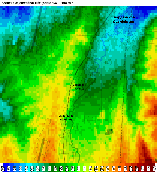
Below is the Elevation map of Sofiivka, which displays elevation range with different colors. Scale of the first map is from 137 to 194 m (449 to 636 ft) with average elevation of 161.7 meters (=531 ft) [note 1]
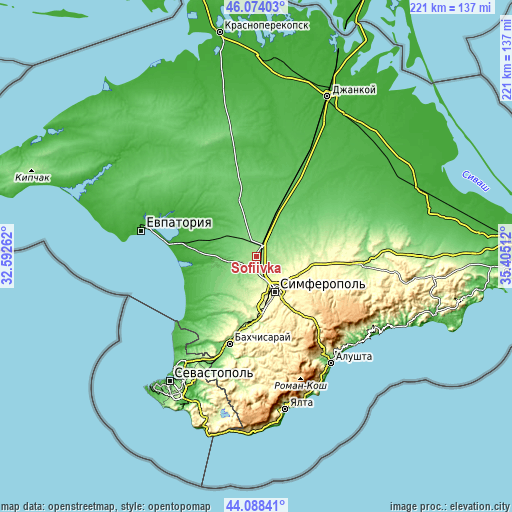
These maps also provides idea of topography and contour of this city, they are displayed at different zoom levels. More info about maps, scale and edge coordinates you can find below images.
| \ | Map #1 | Topo.Map |
| Scale [m] | 137..194 m | × |
| Scale [ft] | 449..636 ft | × |
| Average | 161.7 m = 531 ft | × |
| Width | 6.9 km = 4.3 mi | 220.8 km = 137.2 mi |
| Height | 6.9 km = 4.3 mi | 220.8 km = 137.2 mi |
| ↑Max Latitude | 45.120867° | 46.07403° |
| Latitude at center | 45.08985° | 45.08985° |
| ↓Min Latitude | 45.058816° | 44.08841° |
| ← Min Longitude | 33.954925° | 32.59262° |
| Longitude center | 33.99887° | 33.99887° |
| →Max Longitude | 34.042815° | 35.40512° |
Nearby cities:
Cities around Sofiivka sort by population:
• Hvardiiske elevation 143 m
3.5 km,  30°
30°
• Ukromnoye 177 m
5.3 km,  176°
176°
• Komsomol’skoye 191 m
8.3 km,  162°
162°
• Rodnikovo 159 m
6.3 km,  214°
214°
• Krasna Zor'ka 138 m
5.9 km, 33°
• Pervomayskoye 139 m
5.7 km,  64°
64°
• Shkol’noye 128 m
8.7 km,  245°
245°
• Aeroflotskiy 204 m
8 km, 179°
• Malen’koye 164 m
1.6 km, 178°
• Sovkhoznoye 182 m
6.7 km,  171°
171°
• Chaykino 166 m
6.9 km,  97°
97°
• Solnechnoye 182 m
8.2 km,  125°
125°
Multilingual:
 En español:
Sofiivka elevación 157 m.
 En France:
Sofiivka élévation 157 m.
 Auf Deutsch:
Sofiivka höhe über dem Meeresspiegel ist 157 m.

Sources and notes:
- [note 1] Map square and city borders are not equal. Map elevation data is calculated only from area inside that square.
- [src 1] Elevation data from geonames database provided with same terms of usage.
- [src 2] The elevation map of Sofiivka is generated using elevation data from NASA's 3 arcsec (90m) resolution SRTM data.
- [src 3] Base (background) map © OpenStreetMap contributors tiles are generated by Geofabrik and OpenTopoMap.
Copyright & License:
This Sofiivka Elevation Map is licensed under CC BY-SA. You may reuse any part from this page, if you give a proper credit by linking to this URL:
 More info on terms of use page.