Aeroflotskiy elevation
Aeroflotskiy (Republic of Crimea, Gorodskoy okrug Simferopol), Ukraine elevation is 204 meters and Aeroflotskiy elevation in feet is 669 ft above sea level [src 1]. Aeroflotskiy is a populated place (feature code) with elevation that is 47 meters (154 ft) bigger than average city elevation in Ukraine.
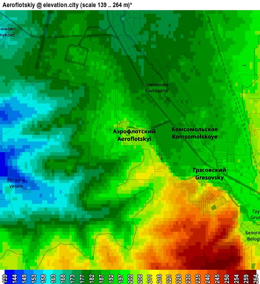
Below is the Elevation map of Aeroflotskiy, which displays elevation range with different colors. Scale of the first map is from 139 to 264 m (456 to 866 ft) with average elevation of 191.5 meters (=628 ft) [note 1]
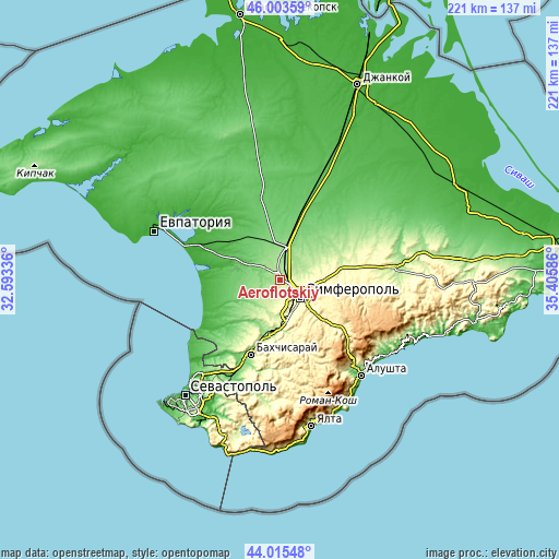
These maps also provides idea of topography and contour of this city, they are displayed at different zoom levels. More info about maps, scale and edge coordinates you can find below images.
| \ | Map #1 | Topo.Map |
| Scale [m] | 139..264 m | × |
| Scale [ft] | 456..866 ft | × |
| Average | 191.5 m = 628 ft | × |
| Width | 6.91 km = 4.3 mi | 221.1 km = 137.4 mi |
| Height | 6.91 km = 4.3 mi | 221 km = 137.3 mi |
| ↑Max Latitude | 45.049216° | 46.00359° |
| Latitude at center | 45.01816° | 45.01816° |
| ↓Min Latitude | 44.987087° | 44.01548° |
| ← Min Longitude | 33.955665° | 32.59336° |
| Longitude center | 33.99961° | 33.99961° |
| →Max Longitude | 34.043555° | 35.40586° |
Nearby cities:
Cities around Aeroflotskiy sort by population:
• Gresovskiy elevation 199 m
2.4 km,  117°
117°
• Mirnoye 214 m
6.2 km,  128°
128°
• Molodyozhnoye 219 m
4.7 km,  110°
110°
• Ukromnoye 177 m
2.7 km,  5°
5°
• Komsomol’skoye 191 m
2.4 km,  87°
87°
• Agrarnoye 237 m
4.5 km, 93°
• Rodnikovo 159 m
4.5 km,  307°
307°
• Sofiivka 157 m
8 km,  359°
359°
• Beloglinka 205 m
4.2 km, 128°
• Malen’koye 164 m
6.4 km, 359°
• Sovkhoznoye 182 m
1.6 km,  32°
32°
• Solnechnoye 182 m
7.4 km,  63°
63°
Multilingual:
 En español:
Aeroflotskiy elevación 204 m.
 En France:
Aeroflotskiy élévation 204 m.
 Auf Deutsch:
Aeroflotskiy höhe über dem Meeresspiegel ist 204 m.

Sources and notes:
- [note 1] Map square and city borders are not equal. Map elevation data is calculated only from area inside that square.
- [src 1] Elevation data from geonames database provided with same terms of usage.
- [src 2] The elevation map of Aeroflotskiy is generated using elevation data from NASA's 3 arcsec (90m) resolution SRTM data.
- [src 3] Base (background) map © OpenStreetMap contributors tiles are generated by Geofabrik and OpenTopoMap.
Copyright & License:
This Aeroflotskiy Elevation Map is licensed under CC BY-SA. You may reuse any part from this page, if you give a proper credit by linking to this URL:
 More info on terms of use page.