Krasna Zor'ka elevation
Krasna Zor'ka (Republic of Crimea, Simferopol Raion), Ukraine elevation is 138 meters and Krasna Zor'ka elevation in feet is 453 ft above sea level [src 1]. Krasna Zor'ka is a populated place (feature code) with elevation that is 19 meters (62 ft) smaller than average city elevation in Ukraine.
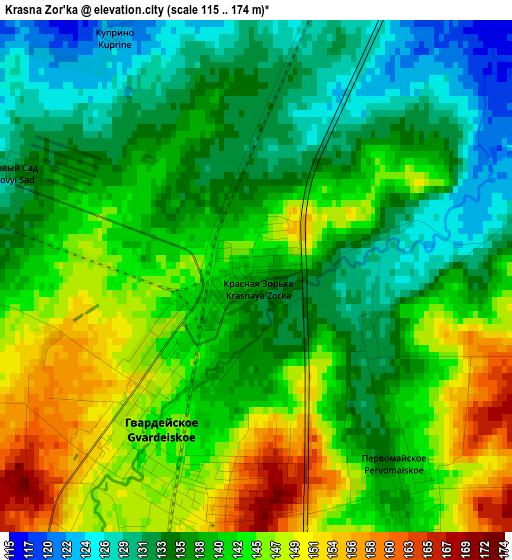
Below is the Elevation map of Krasna Zor'ka, which displays elevation range with different colors. Scale of the first map is from 115 to 174 m (377 to 571 ft) with average elevation of 139.7 meters (=458 ft) [note 1]
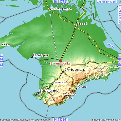
These maps also provides idea of topography and contour of this city, they are displayed at different zoom levels. More info about maps, scale and edge coordinates you can find below images.
| \ | Map #1 | Topo.Map |
| Scale [m] | 115..174 m | × |
| Scale [ft] | 377..571 ft | × |
| Average | 139.7 m = 458 ft | × |
| Width | 6.89 km = 4.3 mi | 220.6 km = 137.1 mi |
| Height | 6.89 km = 4.3 mi | 220.6 km = 137.1 mi |
| ↑Max Latitude | 45.165313° | 46.11773° |
| Latitude at center | 45.13432° | 45.13432° |
| ↓Min Latitude | 45.10331° | 44.13366° |
| ← Min Longitude | 33.996205° | 32.6339° |
| Longitude center | 34.04015° | 34.04015° |
| →Max Longitude | 34.084095° | 35.4464° |
Nearby cities:
Cities around Krasna Zor'ka sort by population:
• Hvardiiske elevation 143 m
2.4 km,  216°
216°
• Ukromnoye 177 m
10.6 km,  195°
195°
• Sofiivka 157 m
5.9 km,  213°
213°
• Novoandreyevka 108 m
8.3 km,  30°
30°
• Pervomayskoye 139 m
3.1 km,  142°
142°
• Malen’koye 164 m
7.2 km, 206°
• Shirokoye 112 m
7.4 km,  6°
6°
• Zhuravlyovka 116 m
5.8 km,  324°
324°
• Sovkhoznoye 182 m
11.8 km,  191°
191°
• Chaykino 166 m
6.8 km,  147°
147°
• Krasnoye 134 m
4.3 km,  81°
81°
• Solnechnoye 182 m
10.2 km,  160°
160°
Multilingual:
 En español:
Krasna Zor'ka elevación 138 m.
 En France:
Krasna Zor'ka élévation 138 m.
 Auf Deutsch:
Krasna Zor'ka höhe über dem Meeresspiegel ist 138 m.
 На русском:
Карача́-Канги́л, Krasnaya Zor’ka, Красная Зорька высота над уровнем моря 138 м
Sources and notes:
- [note 1] Map square and city borders are not equal. Map elevation data is calculated only from area inside that square.
- [src 1] Elevation data from geonames database provided with same terms of usage.
- [src 2] The elevation map of Krasna Zor'ka is generated using elevation data from NASA's 3 arcsec (90m) resolution SRTM data.
- [src 3] Base (background) map © OpenStreetMap contributors tiles are generated by Geofabrik and OpenTopoMap.
Copyright & License:
This Krasna Zor'ka Elevation Map is licensed under CC BY-SA. You may reuse any part from this page, if you give a proper credit by linking to this URL:
 More info on terms of use page.