Starobil’s’k elevation
Starobil’s’k (Luhansk), Ukraine elevation is 62 meters and Starobil’s’k elevation in feet is 203 ft above sea level [src 1]. Starobil’s’k is a seat of a second-order administrative division (feature code) with elevation that is 95 meters (312 ft) smaller than average city elevation in Ukraine.
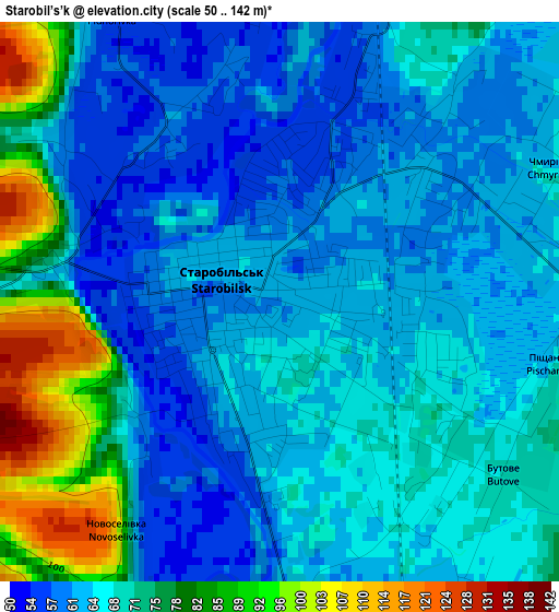
Below is the Elevation map of Starobil’s’k, which displays elevation range with different colors. Scale of the first map is from 50 to 142 m (164 to 466 ft) with average elevation of 68.4 meters (=224 ft) [note 1]
These maps also provides idea of topography and contour of this city, they are displayed at different zoom levels. More info about maps, scale and edge coordinates you can find below images.
| \ | Map #1 | Map #2 | Topo.Map |
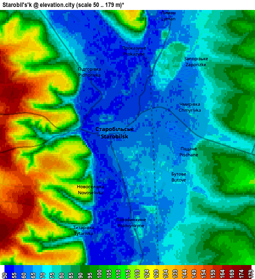
| Scale [m] | 50..142 m | 50..179 m | × |
| Scale [ft] | 164..466 ft | 164..587 ft | × |
| Average | 68.4 m = 224 ft | 88.4 m = 290 ft | × |
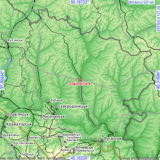
| Width | 6.38 km = 4 mi | 12.75 km = 7.9 mi | 204 km = 126.8 mi |
| Height | 6.38 km = 4 mi | 12.75 km = 7.9 mi | 204 km = 126.8 mi |
| ↑Max Latitude | 49.306981° | 49.335625° | 50.18722° |
| Latitude at center | 49.27832° | 49.27832° | 49.27832° |
| ↓Min Latitude | 49.249642° | 49.220948° | 48.35236° |
| ← Min Longitude | 38.866745° | 38.822799° | 37.50444° |
| Longitude center | 38.91069° | 38.91069° | 38.91069° |
| →Max Longitude | 38.954635° | 38.998581° | 40.31694° |
Nearby cities:
Cities around Starobil’s’k sort by population:
• Syevyerodonets’k elevation 74 m
47.7 km,  219°
219°
• Lysychans’k 183 m
53.7 km, 219°
• Rubizhne 73 m
48.6 km,  232°
232°
• Kreminna 62 m
56.4 km,  243°
243°
• Svatove 70 m
57 km,  284°
284°
• Novopskov 69 m
32.5 km,  23°
23°
• Pryvillya 71 m
52.9 km, 236°
• Bilovods'k 64 m
49.9 km,  98°
98°
• Bilokurakyne 88 m
31.3 km,  335°
335°
• Markivka 115 m
54.9 km,  60°
60°
• Pavlivka 94 m
39.5 km, 338°
• Novoaydar 53 m
35.6 km,  168°
168°
Multilingual:
 En español:
Starobil’s’k elevación 62 m.
 En France:
Starobil’s’k élévation 62 m.
 Auf Deutsch:
Starobil’s’k höhe über dem Meeresspiegel ist 62 m.

Sources and notes:
- [note 1] Map square and city borders are not equal. Map elevation data is calculated only from area inside that square.
- [src 1] Elevation data from geonames database provided with same terms of usage.
- [src 2] The elevation map of Starobil’s’k is generated using elevation data from NASA's 3 arcsec (90m) resolution SRTM data.
- [src 3] Base (background) map © OpenStreetMap contributors tiles are generated by Geofabrik and OpenTopoMap.
Copyright & License:
This Starobil’s’k Elevation Map is licensed under CC BY-SA. You may reuse any part from this page, if you give a proper credit by linking to this URL:
 More info on terms of use page.