Pryvillya elevation
Pryvillya (Luhansk), Ukraine elevation is 71 meters and Pryvillya elevation in feet is 233 ft above sea level [src 1]. Pryvillya is a populated place (feature code) with elevation that is 86 meters (282 ft) smaller than average city elevation in Ukraine.
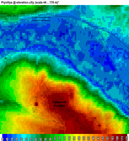
Below is the Elevation map of Pryvillya, which displays elevation range with different colors. Scale of the first map is from 44 to 178 m (144 to 584 ft) with average elevation of 91.6 meters (=301 ft) [note 1]
These maps also provides idea of topography and contour of this city, they are displayed at different zoom levels. More info about maps, scale and edge coordinates you can find below images.
| \ | Map #1 | Map #2 | Topo.Map |
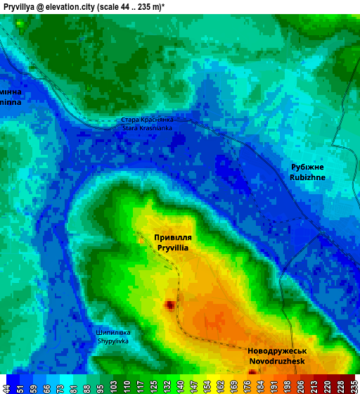
| Scale [m] | 44..178 m | 44..235 m | × |
| Scale [ft] | 144..584 ft | 144..771 ft | × |
| Average | 91.6 m = 301 ft | 93.4 m = 306 ft | × |
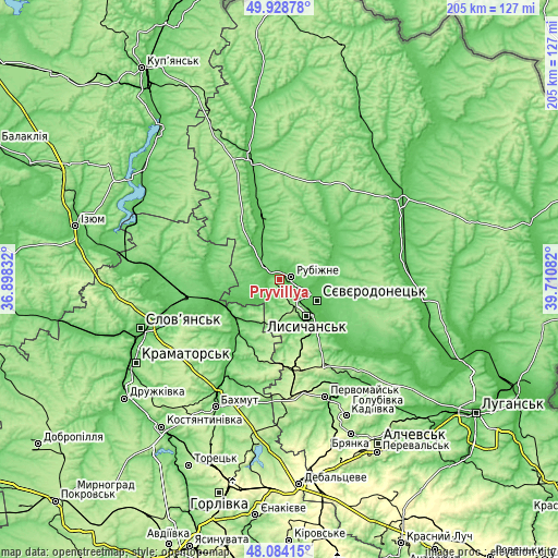
| Width | 6.41 km = 4 mi | 12.82 km = 8 mi | 205.1 km = 127.4 mi |
| Height | 6.41 km = 4 mi | 12.82 km = 8 mi | 205.1 km = 127.4 mi |
| ↑Max Latitude | 49.043824° | 49.072621° | 49.92878° |
| Latitude at center | 49.01501° | 49.01501° | 49.01501° |
| ↓Min Latitude | 48.98618° | 48.957333° | 48.08415° |
| ← Min Longitude | 38.260625° | 38.216679° | 36.89832° |
| Longitude center | 38.30457° | 38.30457° | 38.30457° |
| →Max Longitude | 38.348515° | 38.392461° | 39.71082° |
Nearby cities:
Cities around Pryvillya sort by population:
• Syevyerodonets’k elevation 74 m
15.5 km,  118°
118°
• Lysychans’k 183 m
15.8 km,  140°
140°
• Rubizhne 73 m
5.5 km,  93°
93°
• Kreminna 62 m
7.4 km,  301°
301°
• Sivers’k 69 m
22.2 km,  222°
222°
• Toshkivka 131 m
33 km, 142°
• Bilohorivka 70 m
10.8 km,  202°
202°
• Serebryanka 77 m
16.3 km,  229°
229°
• Kryva Luka 67 m
33.2 km,  241°
241°
• Zarichne 71 m
27.2 km,  271°
271°
• Yampil’ 57 m
26.9 km,  250°
250°
• Terny 76 m
26.5 km,  288°
288°
Multilingual:
 En español:
Pryvillya elevación 71 m.
 En France:
Pryvillya élévation 71 m.
 Auf Deutsch:
Pryvillya höhe über dem Meeresspiegel ist 71 m.

Sources and notes:
- [note 1] Map square and city borders are not equal. Map elevation data is calculated only from area inside that square.
- [src 1] Elevation data from geonames database provided with same terms of usage.
- [src 2] The elevation map of Pryvillya is generated using elevation data from NASA's 3 arcsec (90m) resolution SRTM data.
- [src 3] Base (background) map © OpenStreetMap contributors tiles are generated by Geofabrik and OpenTopoMap.
Copyright & License:
This Pryvillya Elevation Map is licensed under CC BY-SA. You may reuse any part from this page, if you give a proper credit by linking to this URL:
 More info on terms of use page.