Zboriv elevation
Zboriv (Ternopil), Ukraine elevation is 354 meters and Zboriv elevation in feet is 1161 ft above sea level [src 1]. Zboriv is a seat of a second-order administrative division (feature code) with elevation that is 197 meters (646 ft) bigger than average city elevation in Ukraine.
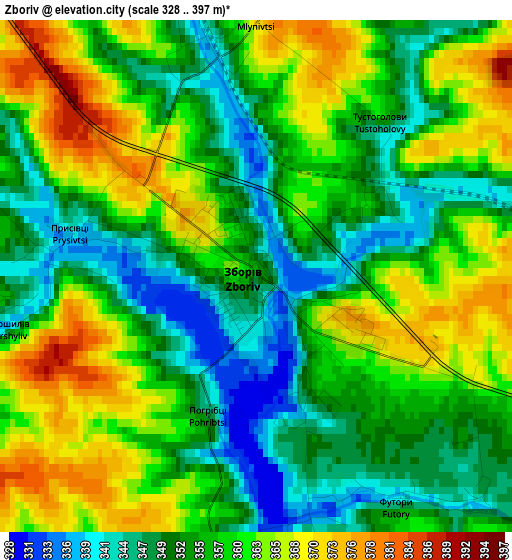
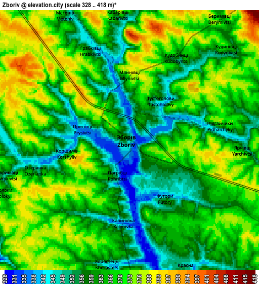
Below is the Elevation map of Zboriv, which displays elevation range with different colors. Scale of the first map is from 328 to 397 m (1076 to 1302 ft) with average elevation of 357 meters (=1171 ft) [note 1]
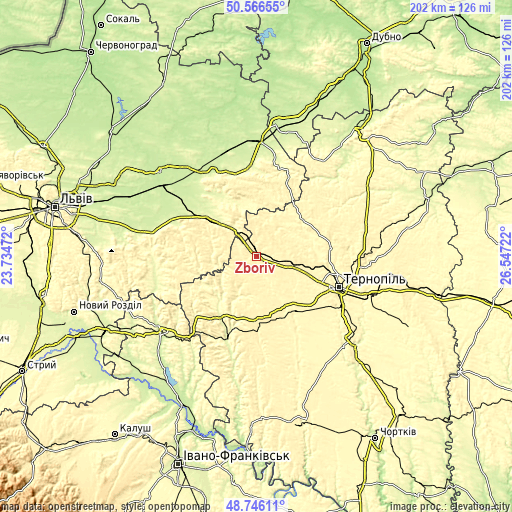
These maps also provides idea of topography and contour of this city, they are displayed at different zoom levels. More info about maps, scale and edge coordinates you can find below images.
| \ | Map #1 | Map #2 | Topo.Map |
| Scale [m] | 328..397 m | 328..418 m | × |
| Scale [ft] | 1076..1302 ft | 1076..1371 ft | × |
| Average | 357 m = 1171 ft | 365 m = 1198 ft | × |
| Width | 6.33 km = 3.9 mi | 12.65 km = 7.9 mi | 202.4 km = 125.8 mi |
| Height | 6.33 km = 3.9 mi | 12.65 km = 7.9 mi | 202.4 km = 125.8 mi |
| ↑Max Latitude | 49.693276° | 49.721695° | 50.56655° |
| Latitude at center | 49.66484° | 49.66484° | 49.66484° |
| ↓Min Latitude | 49.636388° | 49.607919° | 48.74611° |
| ← Min Longitude | 25.097025° | 25.053079° | 23.73472° |
| Longitude center | 25.14097° | 25.14097° | 25.14097° |
| →Max Longitude | 25.184915° | 25.228861° | 26.54722° |
Nearby cities:
Cities around Zboriv sort by population:
• Ternopil elevation 317 m
34.6 km,  110°
110°
• Zolochiv 276 m
23.7 km,  311°
311°
• Бережани 305 m
28.2 km,  212°
212°
• Kozova 361 m
25.5 km,  178°
178°
• Peremyshlyany 301 m
41.9 km,  270°
270°
• Ozerna 351 m
14.1 km, 106°
• Petrikov 320 m
34.9 km,  115°
115°
• Zaliztsi 360 m
21.9 km,  49°
49°
• Pidkamin’ 368 m
33.7 km,  21°
21°
• Olesko 232 m
37.5 km,  331°
331°
• Pomoriany 323 m
15.4 km,  260°
260°
• Pidhirtsi 313 m
33.4 km,  339°
339°
Multilingual:
 En español:
Zboriv elevación 354 m.
 En France:
Zboriv élévation 354 m.


Sources and notes:
- [note 1] Map square and city borders are not equal. Map elevation data is calculated only from area inside that square.
- [src 1] Elevation data from geonames database provided with same terms of usage.
- [src 2] The elevation map of Zboriv is generated using elevation data from NASA's 3 arcsec (90m) resolution SRTM data.
- [src 3] Base (background) map © OpenStreetMap contributors tiles are generated by Geofabrik and OpenTopoMap.
Copyright & License:
This Zboriv Elevation Map is licensed under CC BY-SA. You may reuse any part from this page, if you give a proper credit by linking to this URL:
 More info on terms of use page.