Kintinku elevation
Kintinku (Singida, Manyoni), Tanzania elevation is 848 meters and Kintinku elevation in feet is 2782 ft above sea level [src 1]. Kintinku is a populated place (feature code) with elevation that is 95 meters (312 ft) smaller than average city elevation in Tanzania.
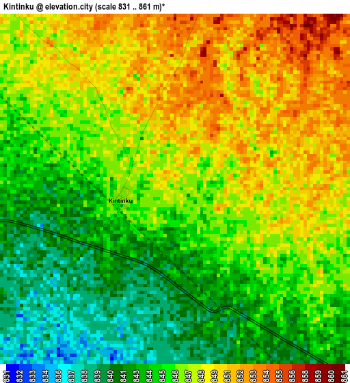
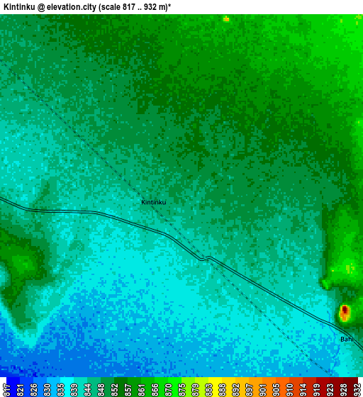
Below is the Elevation map of Kintinku, which displays elevation range with different colors. Scale of the first map is from 831 to 861 m (2726 to 2825 ft) with average elevation of 846 meters (=2776 ft) [note 1]
These maps also provides idea of topography and contour of this city, they are displayed at different zoom levels. More info about maps, scale and edge coordinates you can find below images.
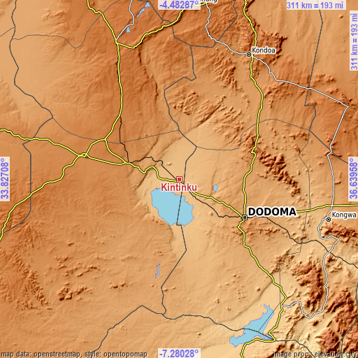
| \ | Map #1 | Map #2 | Topo.Map |
| Scale [m] | 831..861 m | 817..932 m | × |
| Scale [ft] | 2726..2825 ft | 2680..3058 ft | × |
| Average | 846 m = 2776 ft | 847.3 m = 2780 ft | × |
| Width | 9.72 km = 6 mi | 19.44 km = 12.1 mi | 311 km = 193.2 mi |
| Height | 9.72 km = 6 mi | 19.44 km = 12.1 mi | 311.1 km = 193.3 mi |
| ↑Max Latitude | -5.839614° | -5.795895° | -4.48287° |
| Latitude at center | -5.88333° | -5.88333° | -5.88333° |
| ↓Min Latitude | -5.927042° | -5.970751° | -7.28028° |
| ← Min Longitude | 35.189385° | 35.145439° | 33.82708° |
| Longitude center | 35.23333° | 35.23333° | 35.23333° |
| →Max Longitude | 35.277275° | 35.321221° | 36.63958° |
Nearby cities:
Cities around Kintinku sort by population:
• Dodoma elevation 1125 m
64.5 km,  119°
119°
• Singida 1508 m
130.4 km,  335°
335°
• Mgandu 1486 m
121.9 km,  266°
266°
• Kondoa 1378 m
125.1 km,  29°
29°
• Itigi 1300 m
85.4 km,  283°
283°
• Ikungi 1525 m
98.1 km,  328°
328°
• Puma 1588 m
112.7 km, 330°
• Mungaa 1608 m
109 km, 339°
• Kongwa 1023 m
135.5 km,  105°
105°
• Kisasa 1117 m
69.8 km, 117°
• Kilimatinde 1085 m
31.6 km, 276°
• Msanga 1012 m
90.4 km,  101°
101°
Multilingual:
 En español:
Kintinku elevación 848 m.
 En France:
Kintinku élévation 848 m.
 Auf Deutsch:
Kintinku höhe über dem Meeresspiegel ist 848 m.

Sources and notes:
- [note 1] Map square and city borders are not equal. Map elevation data is calculated only from area inside that square.
- [src 1] Elevation data from geonames database provided with same terms of usage.
- [src 2] The elevation map of Kintinku is generated using elevation data from NASA's 3 arcsec (90m) resolution SRTM data.
- [src 3] Base (background) map © OpenStreetMap contributors tiles are generated by Geofabrik and OpenTopoMap.
Copyright & License:
This Kintinku Elevation Map is licensed under CC BY-SA. You may reuse any part from this page, if you give a proper credit by linking to this URL:
 More info on terms of use page.