Itigi elevation
Itigi (Singida, Manyoni), Tanzania elevation is 1300 meters and Itigi elevation in feet is 4265 ft above sea level [src 1]. Itigi is a populated place (feature code) with elevation that is 357 meters (1171 ft) bigger than average city elevation in Tanzania.
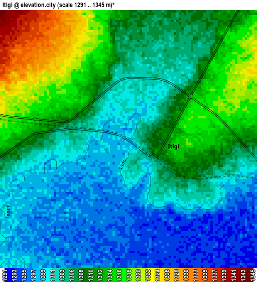
Below is the Elevation map of Itigi, which displays elevation range with different colors. Scale of the first map is from 1291 to 1345 m (4236 to 4413 ft) with average elevation of 1306.6 meters (=4287 ft) [note 1]
These maps also provides idea of topography and contour of this city, they are displayed at different zoom levels. More info about maps, scale and edge coordinates you can find below images.
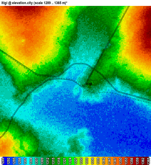
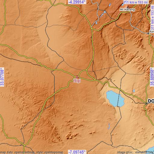
| \ | Map #1 | Map #2 | Topo.Map |
| Scale [m] | 1291..1345 m | 1289..1365 m | × |
| Scale [ft] | 4236..4413 ft | 4229..4478 ft | × |
| Average | 1306.6 m = 4287 ft | 1315.5 m = 4316 ft | × |
| Width | 9.72 km = 6 mi | 19.45 km = 12.1 mi | 311.1 km = 193.3 mi |
| Height | 9.72 km = 6 mi | 19.45 km = 12.1 mi | 311.2 km = 193.4 mi |
| ↑Max Latitude | -5.65627° | -5.612537° | -4.29914° |
| Latitude at center | -5.7° | -5.7° | -5.7° |
| ↓Min Latitude | -5.743726° | -5.787449° | -7.09745° |
| ← Min Longitude | 34.439385° | 34.395439° | 33.07708° |
| Longitude center | 34.48333° | 34.48333° | 34.48333° |
| →Max Longitude | 34.527275° | 34.571221° | 35.88958° |
Nearby cities:
Cities around Itigi sort by population:
• Singida elevation 1508 m
102.4 km,  16°
16°
• Mtinko 1583 m
134.2 km, 17°
• Sepuka 1484 m
105.8 km,  3°
3°
• Mgandu 1486 m
47.7 km,  234°
234°
• Igugunu 1376 m
127.1 km,  7°
7°
• Ikungi 1525 m
70.4 km,  26°
26°
• Ilongero 1609 m
122.5 km, 20°
• Puma 1588 m
82.6 km, 19°
• Mungaa 1608 m
92.8 km, 28°
• Ndago 1443 m
123.2 km,  353°
353°
• Kintinku 848 m
85.4 km,  103°
103°
• Kilimatinde 1085 m
54.3 km,  107°
107°
Multilingual:
 En español:
Itigi elevación 1300 m.
 En France:
Itigi élévation 1300 m.


Sources and notes:
- [note 1] Map square and city borders are not equal. Map elevation data is calculated only from area inside that square.
- [src 1] Elevation data from geonames database provided with same terms of usage.
- [src 2] The elevation map of Itigi is generated using elevation data from NASA's 3 arcsec (90m) resolution SRTM data.
- [src 3] Base (background) map © OpenStreetMap contributors tiles are generated by Geofabrik and OpenTopoMap.
Copyright & License:
This Itigi Elevation Map is licensed under CC BY-SA. You may reuse any part from this page, if you give a proper credit by linking to this URL:
 More info on terms of use page.