Kongwa elevation
Kongwa (Dodoma), Tanzania elevation is 1023 meters and Kongwa elevation in feet is 3356 ft above sea level [src 1]. Kongwa is a populated place (feature code) with elevation that is 80 meters (262 ft) bigger than average city elevation in Tanzania.
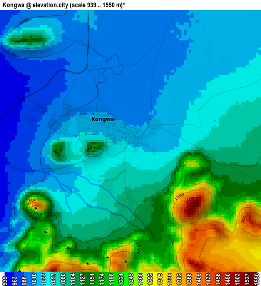
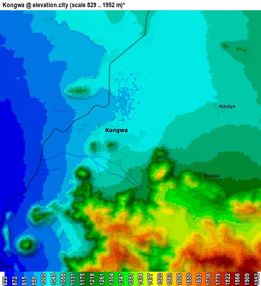
Below is the Elevation map of Kongwa, which displays elevation range with different colors. Scale of the first map is from 939 to 1550 m (3081 to 5085 ft) with average elevation of 1085.2 meters (=3560 ft) [note 1]
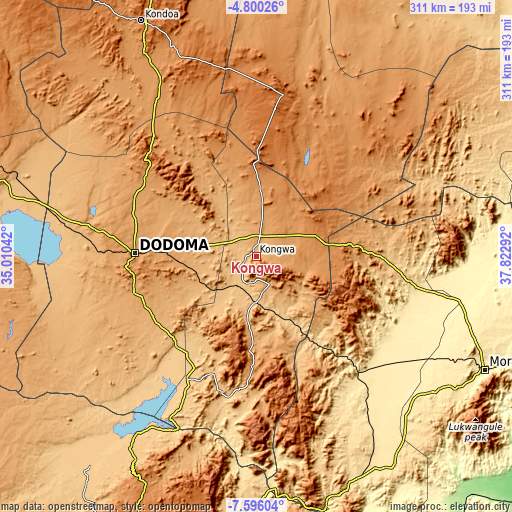
These maps also provides idea of topography and contour of this city, they are displayed at different zoom levels. More info about maps, scale and edge coordinates you can find below images.
| \ | Map #1 | Map #2 | Topo.Map |
| Scale [m] | 939..1550 m | 829..1952 m | × |
| Scale [ft] | 3081..5085 ft | 2720..6404 ft | × |
| Average | 1085.2 m = 3560 ft | 1116.1 m = 3662 ft | × |
| Width | 9.72 km = 6 mi | 19.43 km = 12.1 mi | 310.9 km = 193.2 mi |
| Height | 9.72 km = 6 mi | 19.43 km = 12.1 mi | 310.9 km = 193.2 mi |
| ↑Max Latitude | -6.15631° | -6.112616° | -4.80026° |
| Latitude at center | -6.2° | -6.2° | -6.2° |
| ↓Min Latitude | -6.243686° | -6.287369° | -7.59604° |
| ← Min Longitude | 36.372725° | 36.328779° | 35.01042° |
| Longitude center | 36.41667° | 36.41667° | 36.41667° |
| →Max Longitude | 36.460615° | 36.504561° | 37.82292° |
Nearby cities:
Cities around Kongwa sort by population:
• Dodoma elevation 1125 m
74.9 km,  272°
272°
• Kilosa 495 m
94.2 km,  138°
138°
• Geiro 1284 m
50.1 km,  83°
83°
• Mpwapwa 998 m
18.2 km,  156°
156°
• Kibakwe 1133 m
57.7 km,  185°
185°
• Magole 433 m
107.6 km,  100°
100°
• Msowero 462 m
94.2 km,  113°
113°
• Kimamba 441 m
102.3 km,  129°
129°
• Kisasa 1117 m
69 km, 272°
• Msanga 1012 m
45.5 km,  291°
291°
• Kibaya 1579 m
101.4 km,  9°
9°
• Mvomero 418 m
114.1 km, 95°
Multilingual:
 En español:
Kongwa elevación 1023 m.
 En France:
Kongwa élévation 1023 m.


Sources and notes:
- [note 1] Map square and city borders are not equal. Map elevation data is calculated only from area inside that square.
- [src 1] Elevation data from geonames database provided with same terms of usage.
- [src 2] The elevation map of Kongwa is generated using elevation data from NASA's 3 arcsec (90m) resolution SRTM data.
- [src 3] Base (background) map © OpenStreetMap contributors tiles are generated by Geofabrik and OpenTopoMap.
Copyright & License:
This Kongwa Elevation Map is licensed under CC BY-SA. You may reuse any part from this page, if you give a proper credit by linking to this URL:
 More info on terms of use page.