Mahenge elevation
Mahenge (Morogoro, Ulanga), Tanzania elevation is 1039 meters and Mahenge elevation in feet is 3409 ft above sea level [src 1]. Mahenge is a populated place (feature code) with elevation that is 96 meters (315 ft) bigger than average city elevation in Tanzania.
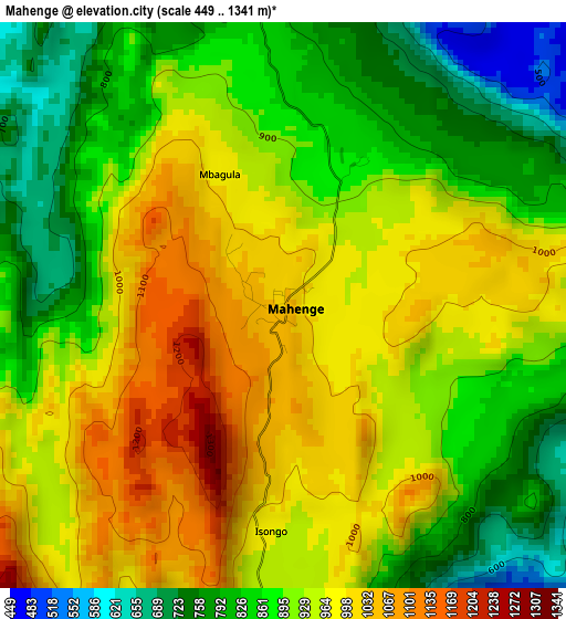
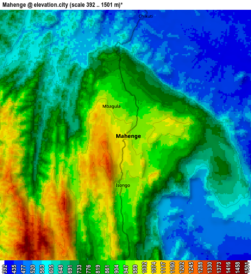
Below is the Elevation map of Mahenge, which displays elevation range with different colors. Scale of the first map is from 449 to 1341 m (1473 to 4400 ft) with average elevation of 914.9 meters (=3002 ft) [note 1]
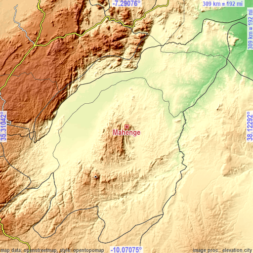
These maps also provides idea of topography and contour of this city, they are displayed at different zoom levels. More info about maps, scale and edge coordinates you can find below images.
| \ | Map #1 | Map #2 | Topo.Map |
| Scale [m] | 449..1341 m | 392..1501 m | × |
| Scale [ft] | 1473..4400 ft | 1286..4925 ft | × |
| Average | 914.9 m = 3002 ft | 756.3 m = 2481 ft | × |
| Width | 9.66 km = 6 mi | 19.32 km = 12 mi | 309.1 km = 192.1 mi |
| Height | 9.66 km = 6 mi | 19.32 km = 12 mi | 309.1 km = 192.1 mi |
| ↑Max Latitude | -8.639886° | -8.596437° | -7.29076° |
| Latitude at center | -8.68333° | -8.68333° | -8.68333° |
| ↓Min Latitude | -8.726769° | -8.770203° | -10.07075° |
| ← Min Longitude | 36.672725° | 36.628779° | 35.31042° |
| Longitude center | 36.71667° | 36.71667° | 36.71667° |
| →Max Longitude | 36.760615° | 36.804561° | 38.12292° |
Nearby cities:
Cities around Mahenge sort by population:
• Iringa elevation 1625 m
151.3 km,  312°
312°
• Ifakara 259 m
61.3 km,  356°
356°
• Kidatu 303 m
112.6 km,  13°
13°
• Kidodi 301 m
124.2 km, 14°
• Mlimba 306 m
99.8 km,  262°
262°
• Ilula 1374 m
134.7 km,  326°
326°
• Malinyi 295 m
69.9 km,  246°
246°
• Mikumi 517 m
145.2 km, 11°
• Lupiro 299 m
33.8 km,  350°
350°
• Mtimbira 302 m
41.8 km, 254°
• Kisanga 150 m
176.1 km,  38°
38°
• Makungu 1251 m
157.6 km,  267°
267°
Multilingual:
 En español:
Mahenge elevación 1039 m.
 En France:
Mahenge élévation 1039 m.
 Auf Deutsch:
Mahenge höhe über dem Meeresspiegel ist 1039 m.

Sources and notes:
- [note 1] Map square and city borders are not equal. Map elevation data is calculated only from area inside that square.
- [src 1] Elevation data from geonames database provided with same terms of usage.
- [src 2] The elevation map of Mahenge is generated using elevation data from NASA's 3 arcsec (90m) resolution SRTM data.
- [src 3] Base (background) map © OpenStreetMap contributors tiles are generated by Geofabrik and OpenTopoMap.
Copyright & License:
This Mahenge Elevation Map is licensed under CC BY-SA. You may reuse any part from this page, if you give a proper credit by linking to this URL:
 More info on terms of use page.