Kidatu elevation
Kidatu (Morogoro, Kilombero), Tanzania elevation is 303 meters and Kidatu elevation in feet is 994 ft above sea level [src 1]. Kidatu is a populated place (feature code) with elevation that is 640 meters (2100 ft) smaller than average city elevation in Tanzania.
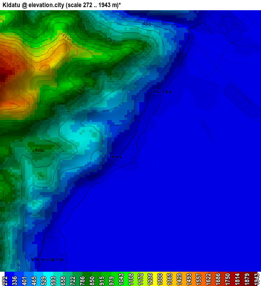
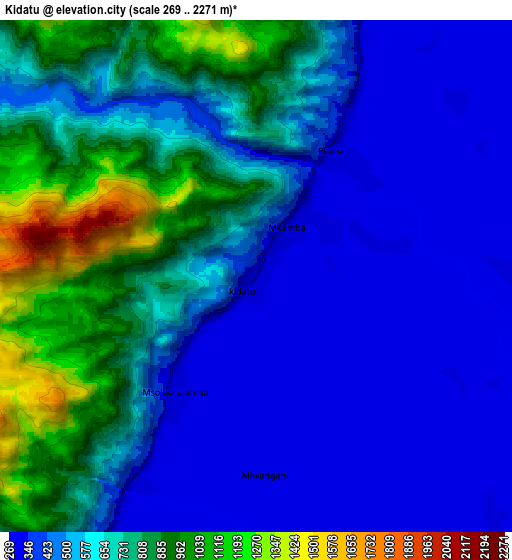
Below is the Elevation map of Kidatu, which displays elevation range with different colors. Scale of the first map is from 272 to 1943 m (892 to 6375 ft) with average elevation of 493.7 meters (=1620 ft) [note 1]
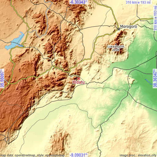
These maps also provides idea of topography and contour of this city, they are displayed at different zoom levels. More info about maps, scale and edge coordinates you can find below images.
| \ | Map #1 | Map #2 | Topo.Map |
| Scale [m] | 272..1943 m | 269..2271 m | × |
| Scale [ft] | 892..6375 ft | 883..7451 ft | × |
| Average | 493.7 m = 1620 ft | 593.8 m = 1948 ft | × |
| Width | 9.68 km = 6 mi | 19.37 km = 12 mi | 309.9 km = 192.6 mi |
| Height | 9.68 km = 6 mi | 19.37 km = 12 mi | 309.9 km = 192.6 mi |
| ↑Max Latitude | -7.655609° | -7.612053° | -6.30343° |
| Latitude at center | -7.69916° | -7.69916° | -7.69916° |
| ↓Min Latitude | -7.742707° | -7.786249° | -9.09031° |
| ← Min Longitude | 36.913275° | 36.869329° | 35.55097° |
| Longitude center | 36.95722° | 36.95722° | 36.95722° |
| →Max Longitude | 37.001165° | 37.045111° | 38.36347° |
Nearby cities:
Cities around Kidatu sort by population:
• Morogoro elevation 504 m
124.8 km,  38°
38°
• Kilosa 495 m
96.3 km,  1°
1°
• Ifakara 259 m
56.9 km,  211°
211°
• Kidodi 301 m
11.8 km,  26°
26°
• Ilula 1374 m
101.5 km,  271°
271°
• Kibakwe 1133 m
127.2 km,  329°
329°
• Msowero 462 m
132.4 km,  11°
11°
• Mikumi 517 m
32.9 km, 4°
• Lupiro 299 m
82.5 km,  202°
202°
• Kimamba 441 m
103.7 km, 10°
• Kisanga 150 m
87.3 km,  70°
70°
• Mahenge 1039 m
112.6 km,  193°
193°
Multilingual:
 En español:
Kidatu elevación 303 m.
 En France:
Kidatu élévation 303 m.


Sources and notes:
- [note 1] Map square and city borders are not equal. Map elevation data is calculated only from area inside that square.
- [src 1] Elevation data from geonames database provided with same terms of usage.
- [src 2] The elevation map of Kidatu is generated using elevation data from NASA's 3 arcsec (90m) resolution SRTM data.
- [src 3] Base (background) map © OpenStreetMap contributors tiles are generated by Geofabrik and OpenTopoMap.
Copyright & License:
This Kidatu Elevation Map is licensed under CC BY-SA. You may reuse any part from this page, if you give a proper credit by linking to this URL:
 More info on terms of use page.