Ngerengere elevation
Ngerengere (Morogoro, Morogoro Rural), Tanzania elevation is 196 meters and Ngerengere elevation in feet is 643 ft above sea level [src 1]. Ngerengere is a populated place (feature code) with elevation that is 747 meters (2451 ft) smaller than average city elevation in Tanzania.
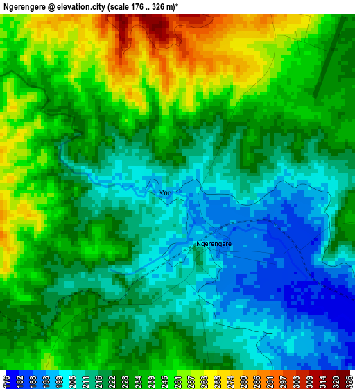
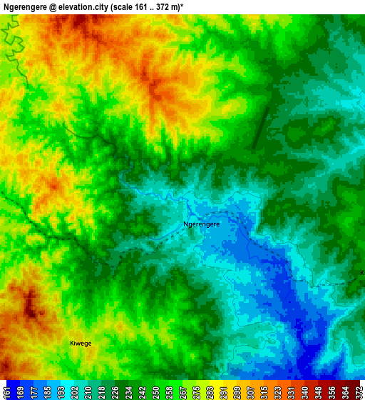
Below is the Elevation map of Ngerengere, which displays elevation range with different colors. Scale of the first map is from 176 to 326 m (577 to 1070 ft) with average elevation of 227.9 meters (=748 ft) [note 1]
These maps also provides idea of topography and contour of this city, they are displayed at different zoom levels. More info about maps, scale and edge coordinates you can find below images.
| \ | Map #1 | Map #2 | Topo.Map |
| Scale [m] | 176..326 m | 161..372 m | × |
| Scale [ft] | 577..1070 ft | 528..1220 ft | × |
| Average | 227.9 m = 748 ft | 246.2 m = 808 ft | × |
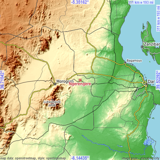
| Width | 9.7 km = 6 mi | 19.41 km = 12.1 mi | 310.5 km = 192.9 mi |
| Height | 9.7 km = 6 mi | 19.41 km = 12.1 mi | 310.6 km = 193 mi |
| ↑Max Latitude | -6.706357° | -6.662711° | -5.35162° |
| Latitude at center | -6.75° | -6.75° | -6.75° |
| ↓Min Latitude | -6.793639° | -6.837274° | -8.14435° |
| ← Min Longitude | 38.072725° | 38.028779° | 36.71042° |
| Longitude center | 38.11667° | 38.11667° | 38.11667° |
| →Max Longitude | 38.160615° | 38.204561° | 39.52292° |
Nearby cities:
Cities around Ngerengere sort by population:
• Morogoro elevation 504 m
50.9 km,  261°
261°
• Bagamoyo 13 m
93.5 km,  68°
68°
• Chalinze 212 m
29 km,  64°
64°
• Mvomero 34 m
82.4 km,  47°
47°
• Mlandizi 26 m
68.3 km,  85°
85°
• Kibaha 154 m
88.4 km, 91°
• Magole 433 m
92 km,  296°
296°
• Msowero 462 m
104.1 km,  283°
283°
• Lugoba 250 m
41.1 km,  35°
35°
• Kisanga 150 m
88.9 km,  210°
210°
• Maneromango 383 m
89 km,  124°
124°
• Mvomero 418 m
89.5 km, 303°
Multilingual:
 En español:
Ngerengere elevación 196 m.
 En France:
Ngerengere élévation 196 m.
 Auf Deutsch:
Ngerengere höhe über dem Meeresspiegel ist 196 m.

Sources and notes:
- [note 1] Map square and city borders are not equal. Map elevation data is calculated only from area inside that square.
- [src 1] Elevation data from geonames database provided with same terms of usage.
- [src 2] The elevation map of Ngerengere is generated using elevation data from NASA's 3 arcsec (90m) resolution SRTM data.
- [src 3] Base (background) map © OpenStreetMap contributors tiles are generated by Geofabrik and OpenTopoMap.
Copyright & License:
This Ngerengere Elevation Map is licensed under CC BY-SA. You may reuse any part from this page, if you give a proper credit by linking to this URL:
 More info on terms of use page.