Kibaha elevation
Kibaha (Pwani, Kibaha Town), Tanzania elevation is 154 meters and Kibaha elevation in feet is 505 ft above sea level [src 1]. Kibaha is a seat of a first-order administrative division (feature code) with elevation that is 789 meters (2589 ft) smaller than average city elevation in Tanzania.
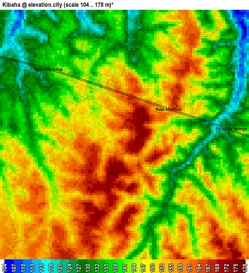
Below is the Elevation map of Kibaha, which displays elevation range with different colors. Scale of the first map is from 104 to 178 m (341 to 584 ft) with average elevation of 145.7 meters (=478 ft) [note 1]
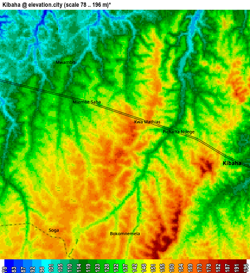
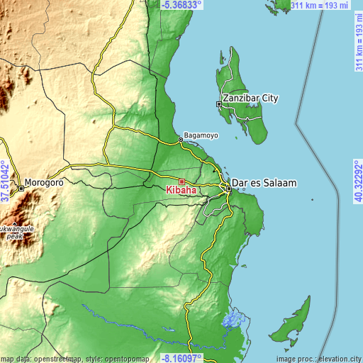
These maps also provides idea of topography and contour of this city, they are displayed at different zoom levels. More info about maps, scale and edge coordinates you can find below images.
| \ | Map #1 | Map #2 | Topo.Map |
| Scale [m] | 104..178 m | 78..196 m | × |
| Scale [ft] | 341..584 ft | 256..643 ft | × |
| Average | 145.7 m = 478 ft | 137.4 m = 451 ft | × |
| Width | 9.7 km = 6 mi | 19.41 km = 12.1 mi | 310.5 km = 192.9 mi |
| Height | 9.7 km = 6 mi | 19.41 km = 12.1 mi | 310.5 km = 192.9 mi |
| ↑Max Latitude | -6.723029° | -6.679384° | -5.36833° |
| Latitude at center | -6.76667° | -6.76667° | -6.76667° |
| ↓Min Latitude | -6.810307° | -6.85394° | -8.16097° |
| ← Min Longitude | 38.872725° | 38.828779° | 37.51042° |
| Longitude center | 38.91667° | 38.91667° | 38.91667° |
| →Max Longitude | 38.960615° | 39.004561° | 40.32292° |
Nearby cities:
Cities around Kibaha sort by population:
• Dar es Salaam elevation 24 m
39.5 km,  99°
99°
• Bagamoyo 13 m
36.1 km,  357°
357°
• Chalinze 212 m
63.8 km,  282°
282°
• Mvomero 34 m
63.7 km,  334°
334°
• Mlandizi 26 m
21.6 km,  290°
290°
• Mkuranga 125 m
50.6 km,  140°
140°
• Vikindu 86 m
49.9 km,  122°
122°
• Magomeni 21 m
37 km, 95°
• Lugoba 250 m
73.4 km,  298°
298°
• Kisarawe 221 m
22.2 km,  131°
131°
• Maneromango 383 m
50.2 km,  196°
196°
• Mahonda 5 m
70.2 km,  59°
59°
Multilingual:
 En español:
Kibaha elevación 154 m.
 En France:
Kibaha élévation 154 m.


Sources and notes:
- [note 1] Map square and city borders are not equal. Map elevation data is calculated only from area inside that square.
- [src 1] Elevation data from geonames database provided with same terms of usage.
- [src 2] The elevation map of Kibaha is generated using elevation data from NASA's 3 arcsec (90m) resolution SRTM data.
- [src 3] Base (background) map © OpenStreetMap contributors tiles are generated by Geofabrik and OpenTopoMap.
Copyright & License:
This Kibaha Elevation Map is licensed under CC BY-SA. You may reuse any part from this page, if you give a proper credit by linking to this URL:
 More info on terms of use page.