Uvinza elevation
Uvinza (Kigoma, Uvinza District), Tanzania elevation is 996 meters and Uvinza elevation in feet is 3268 ft above sea level [src 1]. Uvinza is a populated place (feature code) with elevation that is 53 meters (174 ft) bigger than average city elevation in Tanzania.
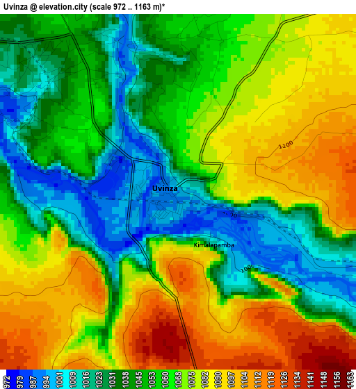
Below is the Elevation map of Uvinza, which displays elevation range with different colors. Scale of the first map is from 972 to 1163 m (3189 to 3816 ft) with average elevation of 1059.9 meters (=3477 ft) [note 1]
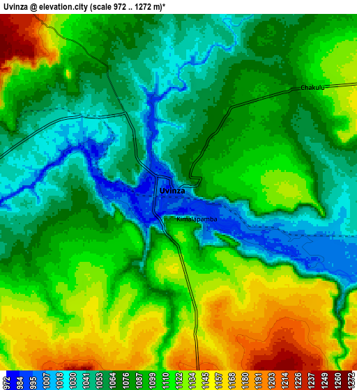
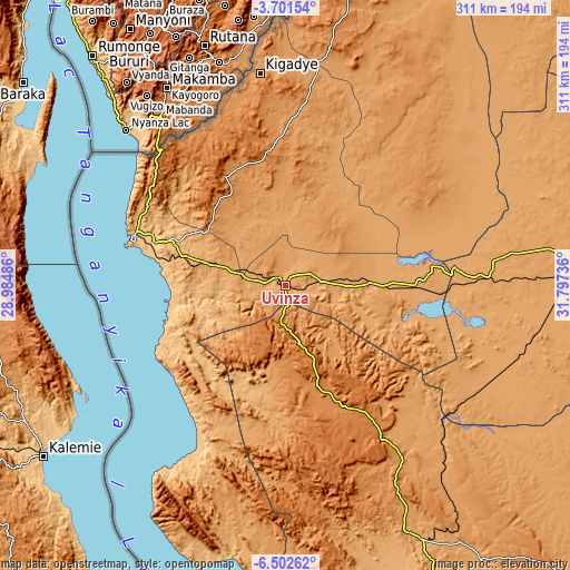
These maps also provides idea of topography and contour of this city, they are displayed at different zoom levels. More info about maps, scale and edge coordinates you can find below images.
| \ | Map #1 | Map #2 | Topo.Map |
| Scale [m] | 972..1163 m | 972..1272 m | × |
| Scale [ft] | 3189..3816 ft | 3189..4173 ft | × |
| Average | 1059.9 m = 3477 ft | 1090.3 m = 3577 ft | × |
| Width | 9.73 km = 6 mi | 19.47 km = 12.1 mi | 311.5 km = 193.6 mi |
| Height | 9.73 km = 6 mi | 19.47 km = 12.1 mi | 311.5 km = 193.6 mi |
| ↑Max Latitude | -5.059837° | -5.016062° | -3.70154° |
| Latitude at center | -5.10361° | -5.10361° | -5.10361° |
| ↓Min Latitude | -5.14738° | -5.191146° | -6.50262° |
| ← Min Longitude | 30.347165° | 30.303219° | 28.98486° |
| Longitude center | 30.39111° | 30.39111° | 30.39111° |
| →Max Longitude | 30.435055° | 30.479001° | 31.79736° |
Nearby cities:
Cities around Uvinza sort by population:
• Kigoma elevation 769 m
88.3 km,  286°
286°
• Mpanda 1100 m
157 km,  151°
151°
• Nguruka 1081 m
72.1 km,  90°
90°
• Kasulu 1310 m
66.7 km,  331°
331°
• Kibondo 1505 m
172.6 km,  12°
12°
• Kakonko 1245 m
212.2 km,  17°
17°
• Urambo 1104 m
183.8 km, 88°
• Mwandiga 871 m
86.7 km, 290°
• Mabamba 1297 m
167.8 km,  4°
4°
• Karema 777 m
191 km,  178°
178°
• Kaliua 1087 m
155.4 km, 88°
• Usoke 1161 m
217 km, 91°
Multilingual:
 En español:
Uvinza elevación 996 m.
 En France:
Uvinza élévation 996 m.


Sources and notes:
- [note 1] Map square and city borders are not equal. Map elevation data is calculated only from area inside that square.
- [src 1] Elevation data from geonames database provided with same terms of usage.
- [src 2] The elevation map of Uvinza is generated using elevation data from NASA's 3 arcsec (90m) resolution SRTM data.
- [src 3] Base (background) map © OpenStreetMap contributors tiles are generated by Geofabrik and OpenTopoMap.
Copyright & License:
This Uvinza Elevation Map is licensed under CC BY-SA. You may reuse any part from this page, if you give a proper credit by linking to this URL:
 More info on terms of use page.