Usoke elevation
Usoke (Tabora, Urambo), Tanzania elevation is 1161 meters and Usoke elevation in feet is 3809 ft above sea level [src 1]. Usoke is a populated place (feature code) with elevation that is 218 meters (715 ft) bigger than average city elevation in Tanzania.
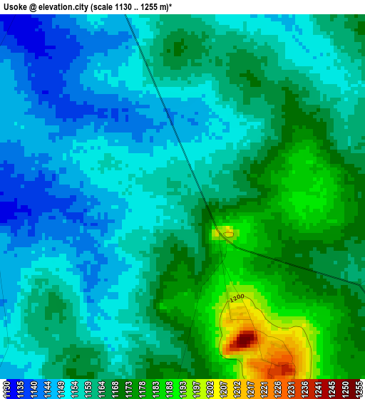
Below is the Elevation map of Usoke, which displays elevation range with different colors. Scale of the first map is from 1130 to 1255 m (3707 to 4117 ft) with average elevation of 1161.8 meters (=3812 ft) [note 1]
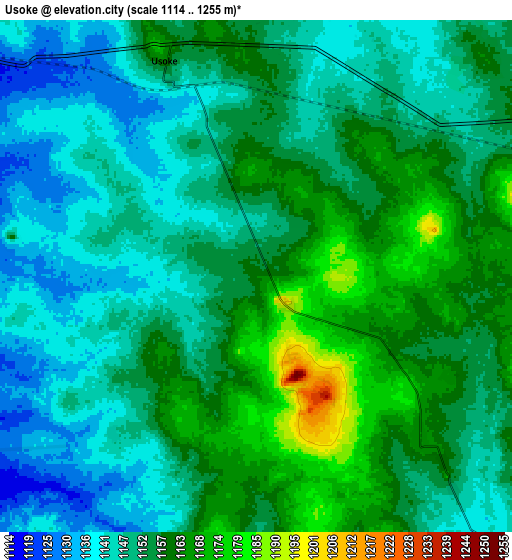
These maps also provides idea of topography and contour of this city, they are displayed at different zoom levels. More info about maps, scale and edge coordinates you can find below images.
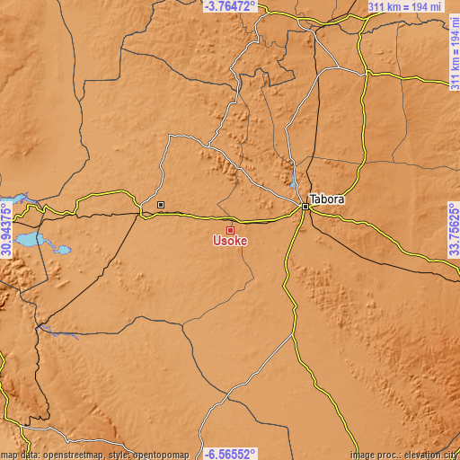
| \ | Map #1 | Map #2 | Topo.Map |
| Scale [m] | 1130..1255 m | 1114..1255 m | × |
| Scale [ft] | 3707..4117 ft | 3655..4117 ft | × |
| Average | 1161.8 m = 3812 ft | 1152.8 m = 3782 ft | × |
| Width | 9.73 km = 6 mi | 19.47 km = 12.1 mi | 311.4 km = 193.5 mi |
| Height | 9.73 km = 6 mi | 19.47 km = 12.1 mi | 311.4 km = 193.5 mi |
| ↑Max Latitude | -5.122902° | -5.07913° | -3.76472° |
| Latitude at center | -5.16667° | -5.16667° | -5.16667° |
| ↓Min Latitude | -5.210435° | -5.254197° | -6.56552° |
| ← Min Longitude | 32.306055° | 32.262109° | 30.94375° |
| Longitude center | 32.35° | 32.35° | 32.35° |
| →Max Longitude | 32.393945° | 32.437891° | 33.75625° |
Nearby cities:
Cities around Usoke sort by population:
• Tabora elevation 1191 m
55.4 km,  72°
72°
• Nguruka 1081 m
145 km,  272°
272°
• Kahama 1249 m
150.8 km,  10°
10°
• Tumbi 1168 m
43.9 km,  75°
75°
• Sikonge 1177 m
69.4 km,  138°
138°
• Nzega 1241 m
140.3 km,  41°
41°
• Urambo 1104 m
35 km,  288°
288°
• Tinde 1154 m
171 km,  33°
33°
• Isaka 1201 m
155 km,  24°
24°
• Mabama 1142 m
20.6 km, 79°
• Kaliua 1087 m
62.7 km,  280°
280°
• Bukene 1200 m
119.4 km, 29°
Multilingual:
 En español:
Usoke elevación 1161 m.
 En France:
Usoke élévation 1161 m.


Sources and notes:
- [note 1] Map square and city borders are not equal. Map elevation data is calculated only from area inside that square.
- [src 1] Elevation data from geonames database provided with same terms of usage.
- [src 2] The elevation map of Usoke is generated using elevation data from NASA's 3 arcsec (90m) resolution SRTM data.
- [src 3] Base (background) map © OpenStreetMap contributors tiles are generated by Geofabrik and OpenTopoMap.
Copyright & License:
This Usoke Elevation Map is licensed under CC BY-SA. You may reuse any part from this page, if you give a proper credit by linking to this URL:
 More info on terms of use page.