Mwandiga elevation
Mwandiga (Kigoma, Kigoma Rural), Tanzania elevation is 871 meters and Mwandiga elevation in feet is 2858 ft above sea level [src 1]. Mwandiga is a populated place (feature code) with elevation that is 72 meters (236 ft) smaller than average city elevation in Tanzania.
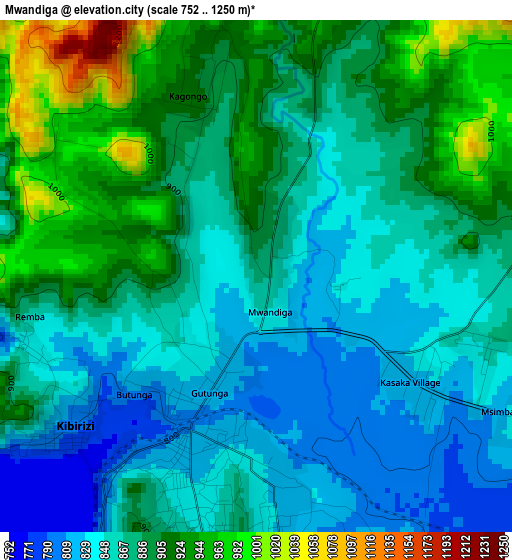
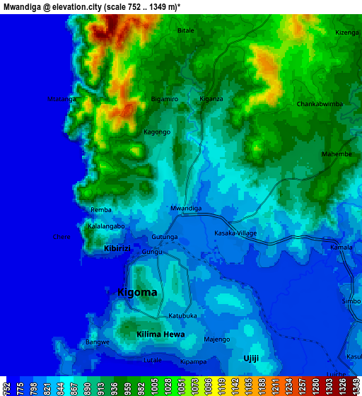
Below is the Elevation map of Mwandiga, which displays elevation range with different colors. Scale of the first map is from 752 to 1250 m (2467 to 4101 ft) with average elevation of 877.9 meters (=2880 ft) [note 1]
These maps also provides idea of topography and contour of this city, they are displayed at different zoom levels. More info about maps, scale and edge coordinates you can find below images.
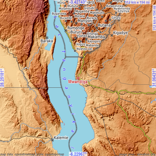
| \ | Map #1 | Map #2 | Topo.Map |
| Scale [m] | 752..1250 m | 752..1349 m | × |
| Scale [ft] | 2467..4101 ft | 2467..4426 ft | × |
| Average | 877.9 m = 2880 ft | 869.4 m = 2852 ft | × |
| Width | 9.74 km = 6.1 mi | 19.48 km = 12.1 mi | 311.6 km = 193.6 mi |
| Height | 9.74 km = 6.1 mi | 19.48 km = 12.1 mi | 311.6 km = 193.6 mi |
| ↑Max Latitude | -4.786209° | -4.742416° | -3.42743° |
| Latitude at center | -4.83° | -4.83° | -4.83° |
| ↓Min Latitude | -4.873788° | -4.917573° | -6.22967° |
| ← Min Longitude | 29.614115° | 29.570169° | 28.25181° |
| Longitude center | 29.65806° | 29.65806° | 29.65806° |
| →Max Longitude | 29.702005° | 29.745951° | 31.06431° |
Nearby cities:
Cities around Mwandiga sort by population:
• Kigoma elevation 769 m
6.3 km,  213°
213°
• Mpanda 1100 m
229.6 km,  137°
137°
• Nguruka 1081 m
156.4 km,  101°
101°
• Kasulu 1310 m
56.7 km,  60°
60°
• Bugarama 1493 m
238.3 km,  23°
23°
• Kibondo 1505 m
181.6 km,  40°
40°
• Kakonko 1245 m
224.9 km, 40°
• Uvinza 996 m
86.7 km,  110°
110°
• Rulenge 1422 m
258.6 km, 24°
• Mabamba 1297 m
165.9 km,  34°
34°
• Karema 777 m
237.6 km,  158°
158°
• Kaliua 1087 m
238 km, 96°
Multilingual:
 En español:
Mwandiga elevación 871 m.
 En France:
Mwandiga élévation 871 m.
 Auf Deutsch:
Mwandiga höhe über dem Meeresspiegel ist 871 m.

Sources and notes:
- [note 1] Map square and city borders are not equal. Map elevation data is calculated only from area inside that square.
- [src 1] Elevation data from geonames database provided with same terms of usage.
- [src 2] The elevation map of Mwandiga is generated using elevation data from NASA's 3 arcsec (90m) resolution SRTM data.
- [src 3] Base (background) map © OpenStreetMap contributors tiles are generated by Geofabrik and OpenTopoMap.
Copyright & License:
This Mwandiga Elevation Map is licensed under CC BY-SA. You may reuse any part from this page, if you give a proper credit by linking to this URL:
 More info on terms of use page.