Akçakoca elevation
Akçakoca (Düzce), Turkey elevation is 59 meters and Akçakoca elevation in feet is 194 ft above sea level [src 1]. Akçakoca is a seat of a second-order administrative division (feature code) with elevation that is 664 meters (2178 ft) smaller than average city elevation in Turkey.
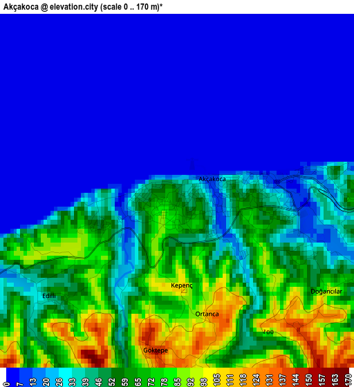
Below is the Elevation map of Akçakoca, which displays elevation range with different colors. Scale of the first map is from 0 to 170 m (0 to 558 ft) with average elevation of 34.8 meters (=114 ft) [note 1]
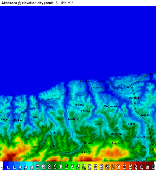
These maps also provides idea of topography and contour of this city, they are displayed at different zoom levels. More info about maps, scale and edge coordinates you can find below images.

| \ | Map #1 | Map #2 | Topo.Map |
| Scale [m] | 0..170 m | -3..511 m | × |
| Scale [ft] | 0..558 ft | -10..1677 ft | × |
| Average | 34.8 m = 114 ft | 65.4 m = 215 ft | × |
| Width | 7.37 km = 4.6 mi | 14.73 km = 9.2 mi | 235.7 km = 146.5 mi |
| Height | 7.37 km = 4.6 mi | 14.73 km = 9.2 mi | 235.7 km = 146.5 mi |
| ↑Max Latitude | 41.119744° | 41.152841° | 42.13798° |
| Latitude at center | 41.08663° | 41.08663° | 41.08663° |
| ↓Min Latitude | 41.053499° | 41.020352° | 40.01818° |
| ← Min Longitude | 31.072285° | 31.028339° | 29.70998° |
| Longitude center | 31.11623° | 31.11623° | 31.11623° |
| →Max Longitude | 31.160175° | 31.204121° | 32.52248° |
Nearby cities:
Cities around Akçakoca sort by population:
• Ereğli elevation 43 m
33.4 km,  49°
49°
• Düzce 153 m
27.8 km,  171°
171°
• Karasu Mahallesi 12 m
27.8 km,  266°
266°
• Karasu 6 m
35.2 km, 273°
• Alaplı 7 m
24.9 km,  64°
64°
• Kocaali 54 m
22.4 km,  260°
260°
• Gölyaka 132 m
35.9 km,  196°
196°
• Yığılca 330 m
30.9 km,  117°
117°
• Gümüşova 160 m
30.4 km,  208°
208°
• Cumayeri 130 m
27.4 km, 210°
• Çilimli 190 m
22.2 km,  194°
194°
• Konuralp 188 m
20.3 km, 173°
Multilingual:
 En español:
Akçakoca elevación 59 m.
 En France:
Akçakoca élévation 59 m.


Sources and notes:
- [note 1] Map square and city borders are not equal. Map elevation data is calculated only from area inside that square.
- [src 1] Elevation data from geonames database provided with same terms of usage.
- [src 2] The elevation map of Akçakoca is generated using elevation data from NASA's 3 arcsec (90m) resolution SRTM data.
- [src 3] Base (background) map © OpenStreetMap contributors tiles are generated by Geofabrik and OpenTopoMap.
Copyright & License:
This Akçakoca Elevation Map is licensed under CC BY-SA. You may reuse any part from this page, if you give a proper credit by linking to this URL:
 More info on terms of use page.