Konuralp elevation
Konuralp (Düzce), Turkey elevation is 188 meters and Konuralp elevation in feet is 617 ft above sea level [src 1]. Konuralp is a seat of a third-order administrative division (feature code) with elevation that is 535 meters (1755 ft) smaller than average city elevation in Turkey.
Below is the Elevation map of Konuralp, which displays elevation range with different colors. Scale of the first map is from 136 to 573 m (446 to 1880 ft) with average elevation of 222.4 meters (=730 ft) [note 1]
These maps also provides idea of topography and contour of this city, they are displayed at different zoom levels. More info about maps, scale and edge coordinates you can find below images.
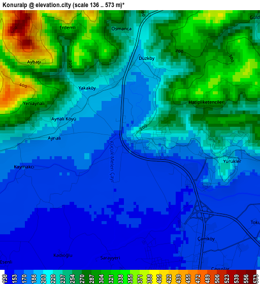
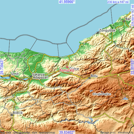
| \ | Map #1 | Topo.Map |
| Scale [m] | 136..573 m | × |
| Scale [ft] | 446..1880 ft | × |
| Average | 222.4 m = 730 ft | × |
| Width | 7.39 km = 4.6 mi | 236.3 km = 146.8 mi |
| Height | 7.39 km = 4.6 mi | 236.3 km = 146.8 mi |
| ↑Max Latitude | 40.938585° | 41.95966° |
| Latitude at center | 40.90538° | 40.90538° |
| ↓Min Latitude | 40.872158° | 39.83402° |
| ← Min Longitude | 31.101735° | 29.73943° |
| Longitude center | 31.14568° | 31.14568° |
| →Max Longitude | 31.189625° | 32.55193° |
Nearby cities:
Cities around Konuralp sort by population:
• Düzce elevation 153 m
7.5 km,  168°
168°
• Karasu Mahallesi 12 m
35.4 km,  301°
301°
• Hendek 185 m
35.5 km,  250°
250°
• Akçakoca 59 m
20.3 km,  353°
353°
• Kocaali 54 m
29.6 km, 303°
• Karadere 443 m
32.2 km,  233°
233°
• Yığılca 330 m
25.7 km,  76°
76°
• Kaynaşlı 362 m
21.2 km,  135°
135°
• Gölyaka 132 m
19 km,  221°
221°
• Gümüşova 160 m
18.4 km, 249°
• Cumayeri 130 m
16.7 km,  257°
257°
• Çilimli 190 m
8.2 km, 260°
Multilingual:
 En español:
Konuralp elevación 188 m.
 En France:
Konuralp élévation 188 m.
 Auf Deutsch:
Konuralp höhe über dem Meeresspiegel ist 188 m.

Sources and notes:
- [note 1] Map square and city borders are not equal. Map elevation data is calculated only from area inside that square.
- [src 1] Elevation data from geonames database provided with same terms of usage.
- [src 2] The elevation map of Konuralp is generated using elevation data from NASA's 3 arcsec (90m) resolution SRTM data.
- [src 3] Base (background) map © OpenStreetMap contributors tiles are generated by Geofabrik and OpenTopoMap.
Copyright & License:
This Konuralp Elevation Map is licensed under CC BY-SA. You may reuse any part from this page, if you give a proper credit by linking to this URL:
 More info on terms of use page.