Çandır elevation
Çandır (Ankara), Turkey elevation is 969 meters and Çandır elevation in feet is 3179 ft above sea level [src 1]. Çandır is a seat of a third-order administrative division (feature code) with elevation that is 246 meters (807 ft) bigger than average city elevation in Turkey.
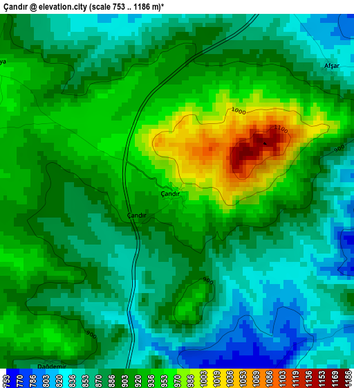
Below is the Elevation map of Çandır, which displays elevation range with different colors. Scale of the first map is from 753 to 1186 m (2470 to 3891 ft) with average elevation of 899.1 meters (=2950 ft) [note 1]
These maps also provides idea of topography and contour of this city, they are displayed at different zoom levels. More info about maps, scale and edge coordinates you can find below images.
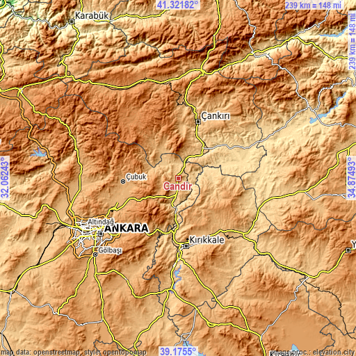
| \ | Map #1 | Topo.Map |
| Scale [m] | 753..1186 m | × |
| Scale [ft] | 2470..3891 ft | × |
| Average | 899.1 m = 2950 ft | × |
| Width | 7.46 km = 4.6 mi | 238.6 km = 148.3 mi |
| Height | 7.46 km = 4.6 mi | 238.6 km = 148.3 mi |
| ↑Max Latitude | 40.290699° | 41.32182° |
| Latitude at center | 40.25717° | 40.25717° |
| ↓Min Latitude | 40.223625° | 39.1755° |
| ← Min Longitude | 33.424735° | 32.06243° |
| Longitude center | 33.46868° | 33.46868° |
| →Max Longitude | 33.512625° | 34.87493° |
Nearby cities:
Cities around Çandır sort by population:
• Khanjarah elevation 727 m
40.1 km,  18°
18°
• Çubuk 999 m
37.1 km,  266°
266°
• Elmadağ 1132 m
42.5 km,  208°
208°
• Kalecik 741 m
18.5 km,  196°
196°
• Akyurt 1041 m
35.2 km,  247°
247°
• Şabanözü 1032 m
29.6 km,  327°
327°
• Sulakyurt 833 m
23.8 km,  117°
117°
• Eldivan 949 m
30.4 km,  4°
4°
• Balışeyh 878 m
43.9 km,  150°
150°
• Kızılırmak 556 m
45 km,  77°
77°
• Yahşihan 707 m
45.3 km,  181°
181°
• Hasayaz 1000 m
12.1 km,  261°
261°
Multilingual:
 En español:
Çandır elevación 969 m.
 En France:
Çandır élévation 969 m.


Sources and notes:
- [note 1] Map square and city borders are not equal. Map elevation data is calculated only from area inside that square.
- [src 1] Elevation data from geonames database provided with same terms of usage.
- [src 2] The elevation map of Çandır is generated using elevation data from NASA's 3 arcsec (90m) resolution SRTM data.
- [src 3] Base (background) map © OpenStreetMap contributors tiles are generated by Geofabrik and OpenTopoMap.
Copyright & License:
This Çandır Elevation Map is licensed under CC BY-SA. You may reuse any part from this page, if you give a proper credit by linking to this URL:
 More info on terms of use page.