Elmadağ elevation
Elmadağ (Ankara), Turkey elevation is 1132 meters and Elmadağ elevation in feet is 3714 ft above sea level [src 1]. Elmadağ is a seat of a second-order administrative division (feature code) with elevation that is 409 meters (1342 ft) bigger than average city elevation in Turkey.
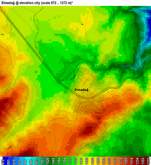
Below is the Elevation map of Elmadağ, which displays elevation range with different colors. Scale of the first map is from 872 to 1372 m (2861 to 4501 ft) with average elevation of 1152.8 meters (=3782 ft) [note 1]
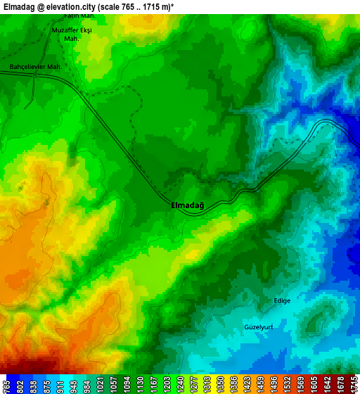
These maps also provides idea of topography and contour of this city, they are displayed at different zoom levels. More info about maps, scale and edge coordinates you can find below images.
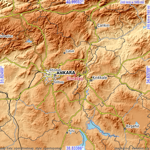
| \ | Map #1 | Map #2 | Topo.Map |
| Scale [m] | 872..1372 m | 765..1715 m | × |
| Scale [ft] | 2861..4501 ft | 2510..5627 ft | × |
| Average | 1152.8 m = 3782 ft | 1139.5 m = 3739 ft | × |
| Width | 7.49 km = 4.7 mi | 14.99 km = 9.3 mi | 239.8 km = 149 mi |
| Height | 7.49 km = 4.7 mi | 14.99 km = 9.3 mi | 239.8 km = 149 mi |
| ↑Max Latitude | 39.954525° | 39.988203° | 40.99082° |
| Latitude at center | 39.92083° | 39.92083° | 39.92083° |
| ↓Min Latitude | 39.887119° | 39.853391° | 38.83386° |
| ← Min Longitude | 33.186885° | 33.142939° | 31.82458° |
| Longitude center | 33.23083° | 33.23083° | 33.23083° |
| →Max Longitude | 33.274775° | 33.318721° | 34.63708° |
Nearby cities:
Cities around Elmadağ sort by population:
• Ankara elevation 874 m
32.1 km,  269°
269°
• Çankaya 889 m
31.4 km, 269°
• Kırıkkale 731 m
25 km,  109°
109°
• Kalecik 741 m
24.8 km,  37°
37°
• Akyurt 1041 m
26.8 km,  332°
332°
• Karakeçili 837 m
38.4 km,  160°
160°
• Gölbaşı 990 m
38.8 km,  248°
248°
• Hasayaz 1000 m
36.5 km,  13°
13°
• Pursaklar 1061 m
31.1 km,  293°
293°
• Mamak 945 m
27.4 km, 274°
• Bahşılı 825 m
22.1 km,  127°
127°
• Yahşihan 707 m
20.5 km, 112°
Multilingual:
 En español:
Elmadağ elevación 1132 m.
 En France:
Elmadağ élévation 1132 m.
 Auf Deutsch:
Elmadağ höhe über dem Meeresspiegel ist 1132 m.

Sources and notes:
- [note 1] Map square and city borders are not equal. Map elevation data is calculated only from area inside that square.
- [src 1] Elevation data from geonames database provided with same terms of usage.
- [src 2] The elevation map of Elmadağ is generated using elevation data from NASA's 3 arcsec (90m) resolution SRTM data.
- [src 3] Base (background) map © OpenStreetMap contributors tiles are generated by Geofabrik and OpenTopoMap.
Copyright & License:
This Elmadağ Elevation Map is licensed under CC BY-SA. You may reuse any part from this page, if you give a proper credit by linking to this URL:
 More info on terms of use page.