Karakeçili elevation
Karakeçili (Kırıkkale), Turkey elevation is 837 meters and Karakeçili elevation in feet is 2746 ft above sea level [src 1]. Karakeçili is a seat of a second-order administrative division (feature code) with elevation that is 114 meters (374 ft) bigger than average city elevation in Turkey.
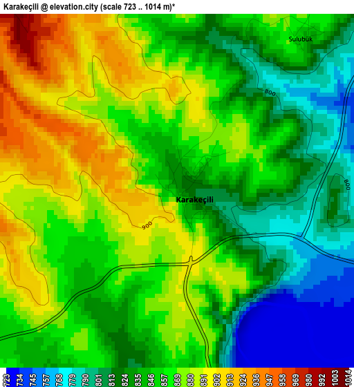
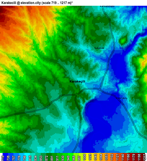
Below is the Elevation map of Karakeçili, which displays elevation range with different colors. Scale of the first map is from 723 to 1014 m (2372 to 3327 ft) with average elevation of 850 meters (=2789 ft) [note 1]
These maps also provides idea of topography and contour of this city, they are displayed at different zoom levels. More info about maps, scale and edge coordinates you can find below images.
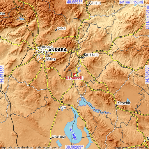
| \ | Map #1 | Map #2 | Topo.Map |
| Scale [m] | 723..1014 m | 719..1217 m | × |
| Scale [ft] | 2372..3327 ft | 2359..3993 ft | × |
| Average | 850 m = 2789 ft | 872.8 m = 2864 ft | × |
| Width | 7.53 km = 4.7 mi | 15.06 km = 9.4 mi | 241 km = 149.8 mi |
| Height | 7.53 km = 4.7 mi | 15.06 km = 9.4 mi | 241 km = 149.8 mi |
| ↑Max Latitude | 39.628025° | 39.661863° | 40.6693° |
| Latitude at center | 39.59417° | 39.59417° | 39.59417° |
| ↓Min Latitude | 39.560298° | 39.52641° | 38.50209° |
| ← Min Longitude | 33.333835° | 33.289889° | 31.97153° |
| Longitude center | 33.37778° | 33.37778° | 33.37778° |
| →Max Longitude | 33.421725° | 33.465671° | 34.78403° |
Nearby cities:
Cities around Karakeçili sort by population:
• Kırıkkale elevation 731 m
30 km,  21°
21°
• Keskin 1140 m
22 km,  66°
66°
• Kaman 1126 m
39.7 km,  131°
131°
• Elmadağ 1132 m
38.4 km,  340°
340°
• Balışeyh 878 m
46.2 km,  39°
39°
• Gölbaşı 990 m
53.3 km,  294°
294°
• Akpınar 1148 m
52.8 km,  107°
107°
• Savcılı 932 m
48.3 km,  147°
147°
• Yahşihan 707 m
29.2 km,  12°
12°
• Bahşılı 825 m
23.5 km, 12°
• Bala 1314 m
22.2 km,  258°
258°
• Çelebi 1247 m
19.1 km,  139°
139°
Multilingual:
 En español:
Karakeçili elevación 837 m.
 En France:
Karakeçili élévation 837 m.
 Auf Deutsch:
Karakeçili höhe über dem Meeresspiegel ist 837 m.

Sources and notes:
- [note 1] Map square and city borders are not equal. Map elevation data is calculated only from area inside that square.
- [src 1] Elevation data from geonames database provided with same terms of usage.
- [src 2] The elevation map of Karakeçili is generated using elevation data from NASA's 3 arcsec (90m) resolution SRTM data.
- [src 3] Base (background) map © OpenStreetMap contributors tiles are generated by Geofabrik and OpenTopoMap.
Copyright & License:
This Karakeçili Elevation Map is licensed under CC BY-SA. You may reuse any part from this page, if you give a proper credit by linking to this URL:
 More info on terms of use page.