Umurbey elevation
Umurbey (Bursa), Turkey elevation is 230 meters and Umurbey elevation in feet is 755 ft above sea level [src 1]. Umurbey is a populated place (feature code) with elevation that is 493 meters (1617 ft) smaller than average city elevation in Turkey.
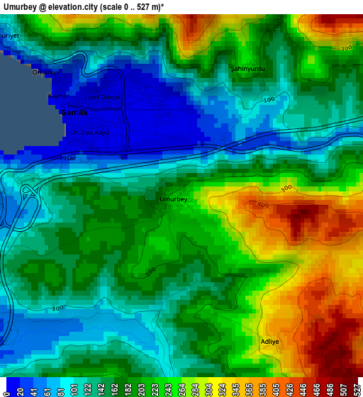
Below is the Elevation map of Umurbey, which displays elevation range with different colors. Scale of the first map is from 0 to 527 m (0 to 1729 ft) with average elevation of 182.9 meters (=600 ft) [note 1]
These maps also provides idea of topography and contour of this city, they are displayed at different zoom levels. More info about maps, scale and edge coordinates you can find below images.
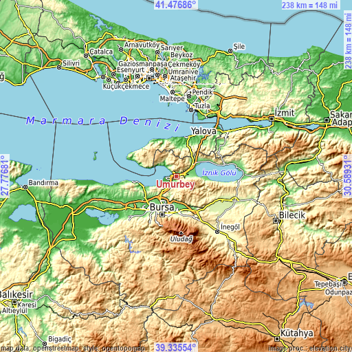
| \ | Map #1 | Topo.Map |
| Scale [m] | 0..527 m | × |
| Scale [ft] | 0..1729 ft | × |
| Average | 182.9 m = 600 ft | × |
| Width | 7.44 km = 4.6 mi | 238.1 km = 147.9 mi |
| Height | 7.44 km = 4.6 mi | 238.1 km = 147.9 mi |
| ↑Max Latitude | 40.44817° | 41.47686° |
| Latitude at center | 40.41472° | 40.41472° |
| ↓Min Latitude | 40.381253° | 39.33554° |
| ← Min Longitude | 29.139115° | 27.77681° |
| Longitude center | 29.18306° | 29.18306° |
| →Max Longitude | 29.227005° | 30.58931° |
Nearby cities:
Cities around Umurbey sort by population:
• Gemlik elevation 5 m
2.7 km,  312°
312°
• Orhangazi 120 m
13.5 km,  52°
52°
• Kestel 122 m
24.2 km,  174°
174°
• Gürsu 110 m
21.8 km,  177°
177°
• Demirtaş 113 m
17.4 km,  204°
204°
• Küçükkumla 11 m
9.3 km, 311°
• Yeniköy 272 m
19.7 km, 47°
• Kadıköy 20 m
23.1 km,  8°
8°
• Çakırlı 198 m
25.5 km,  63°
63°
• Narlıca 203 m
25.4 km,  97°
97°
• Sölöz 125 m
19.8 km, 96°
• Termal 118 m
21.5 km,  357°
357°
Multilingual:
 En español:
Umurbey elevación 230 m.
 En France:
Umurbey élévation 230 m.


Sources and notes:
- [note 1] Map square and city borders are not equal. Map elevation data is calculated only from area inside that square.
- [src 1] Elevation data from geonames database provided with same terms of usage.
- [src 2] The elevation map of Umurbey is generated using elevation data from NASA's 3 arcsec (90m) resolution SRTM data.
- [src 3] Base (background) map © OpenStreetMap contributors tiles are generated by Geofabrik and OpenTopoMap.
Copyright & License:
This Umurbey Elevation Map is licensed under CC BY-SA. You may reuse any part from this page, if you give a proper credit by linking to this URL:
 More info on terms of use page.