Bayat elevation
Bayat (Afyonkarahisar), Turkey elevation is 1063 meters and Bayat elevation in feet is 3488 ft above sea level [src 1]. Bayat is a seat of a second-order administrative division (feature code) with elevation that is 340 meters (1115 ft) bigger than average city elevation in Turkey.
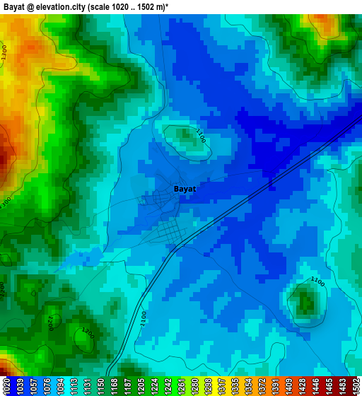
Below is the Elevation map of Bayat, which displays elevation range with different colors. Scale of the first map is from 1020 to 1502 m (3346 to 4928 ft) with average elevation of 1127.2 meters (=3698 ft) [note 1]
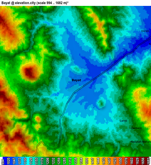
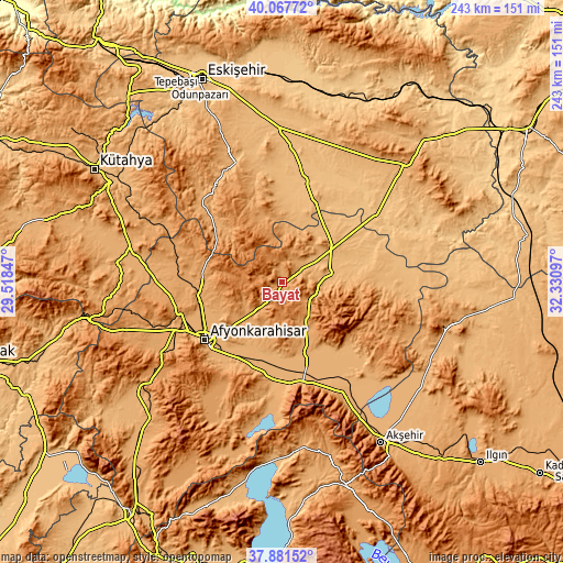
These maps also provides idea of topography and contour of this city, they are displayed at different zoom levels. More info about maps, scale and edge coordinates you can find below images.
| \ | Map #1 | Map #2 | Topo.Map |
| Scale [m] | 1020..1502 m | 994..1682 m | × |
| Scale [ft] | 3346..4928 ft | 3261..5518 ft | × |
| Average | 1127.2 m = 3698 ft | 1226.4 m = 4024 ft | × |
| Width | 7.6 km = 4.7 mi | 15.19 km = 9.4 mi | 243.1 km = 151.1 mi |
| Height | 7.6 km = 4.7 mi | 15.19 km = 9.4 mi | 243.1 km = 151.1 mi |
| ↑Max Latitude | 39.017212° | 39.051347° | 40.06772° |
| Latitude at center | 38.98306° | 38.98306° | 38.98306° |
| ↓Min Latitude | 38.948892° | 38.914707° | 37.88152° |
| ← Min Longitude | 30.880775° | 30.836829° | 29.51847° |
| Longitude center | 30.92472° | 30.92472° | 30.92472° |
| →Max Longitude | 30.968665° | 31.012611° | 32.33097° |
Nearby cities:
Cities around Bayat sort by population:
• Afyonkarahisar elevation 1019 m
41.5 km,  232°
232°
• Bolvadin 995 m
32.1 km,  160°
160°
• Çay 1039 m
44.4 km,  168°
168°
• Emirdağ 964 m
19.9 km,  78°
78°
• İscehisar 1076 m
20.2 km, 228°
• Çifteler 876 m
45.6 km,  12°
12°
• Işıklar 1012 m
38.2 km,  204°
204°
• İhsaniye 1101 m
44.2 km,  276°
276°
• Davulga 1032 m
38.6 km,  90°
90°
• Umraniye 905 m
34.2 km,  51°
51°
• Çobanlar 992 m
33.6 km, 201°
• Han 1220 m
20.3 km,  344°
344°
Multilingual:
 En español:
Bayat elevación 1063 m.
 En France:
Bayat élévation 1063 m.


Sources and notes:
- [note 1] Map square and city borders are not equal. Map elevation data is calculated only from area inside that square.
- [src 1] Elevation data from geonames database provided with same terms of usage.
- [src 2] The elevation map of Bayat is generated using elevation data from NASA's 3 arcsec (90m) resolution SRTM data.
- [src 3] Base (background) map © OpenStreetMap contributors tiles are generated by Geofabrik and OpenTopoMap.
Copyright & License:
This Bayat Elevation Map is licensed under CC BY-SA. You may reuse any part from this page, if you give a proper credit by linking to this URL:
 More info on terms of use page.