Bolvadin elevation
Bolvadin (Afyonkarahisar), Turkey elevation is 995 meters and Bolvadin elevation in feet is 3264 ft above sea level [src 1]. Bolvadin is a seat of a second-order administrative division (feature code) with elevation that is 272 meters (892 ft) bigger than average city elevation in Turkey.
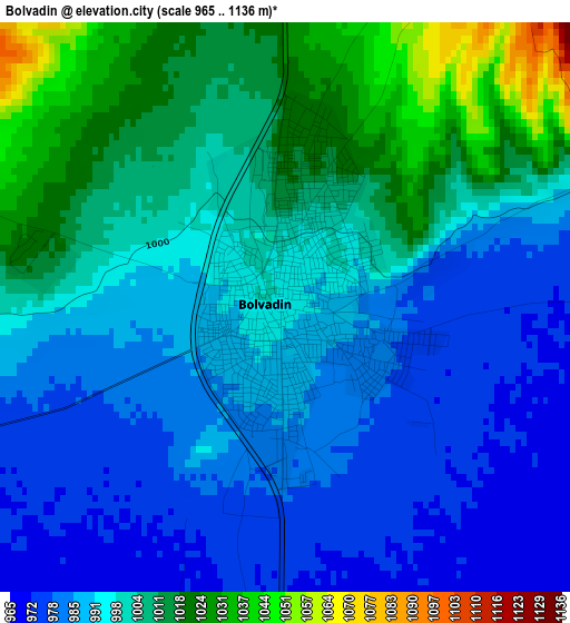
Below is the Elevation map of Bolvadin, which displays elevation range with different colors. Scale of the first map is from 965 to 1136 m (3166 to 3727 ft) with average elevation of 997.2 meters (=3272 ft) [note 1]
These maps also provides idea of topography and contour of this city, they are displayed at different zoom levels. More info about maps, scale and edge coordinates you can find below images.
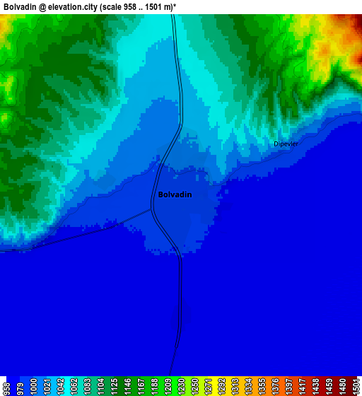
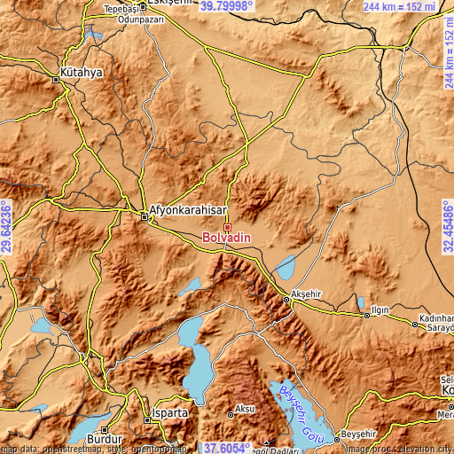
| \ | Map #1 | Map #2 | Topo.Map |
| Scale [m] | 965..1136 m | 958..1501 m | × |
| Scale [ft] | 3166..3727 ft | 3143..4925 ft | × |
| Average | 997.2 m = 3272 ft | 1030.3 m = 3380 ft | × |
| Width | 7.63 km = 4.7 mi | 15.25 km = 9.5 mi | 244 km = 151.6 mi |
| Height | 7.63 km = 4.7 mi | 15.25 km = 9.5 mi | 244 km = 151.6 mi |
| ↑Max Latitude | 38.745393° | 38.779659° | 39.79998° |
| Latitude at center | 38.71111° | 38.71111° | 38.71111° |
| ↓Min Latitude | 38.676811° | 38.642495° | 37.6054° |
| ← Min Longitude | 31.004665° | 30.960719° | 29.64236° |
| Longitude center | 31.04861° | 31.04861° | 31.04861° |
| →Max Longitude | 31.092555° | 31.136501° | 32.45486° |
Nearby cities:
Cities around Bolvadin sort by population:
• Afyonkarahisar elevation 1019 m
44.1 km,  276°
276°
• Yalvaç 1100 m
47.6 km,  166°
166°
• Çay 1039 m
13.4 km,  187°
187°
• Emirdağ 964 m
35.4 km,  14°
14°
• Şuhut 1138 m
48 km,  245°
245°
• İscehisar 1076 m
30.8 km,  302°
302°
• Sultandağı 1017 m
25.4 km,  142°
142°
• Işıklar 1012 m
27.1 km,  260°
260°
• Bayat 1063 m
32.1 km,  340°
340°
• Kumdanlı 1012 m
43.5 km, 188°
• Davulga 1032 m
40.9 km,  43°
43°
• Çobanlar 992 m
23.1 km,  267°
267°
Multilingual:
 En español:
Bolvadin elevación 995 m.
 En France:
Bolvadin élévation 995 m.
 Auf Deutsch:
Bolvadin höhe über dem Meeresspiegel ist 995 m.

Sources and notes:
- [note 1] Map square and city borders are not equal. Map elevation data is calculated only from area inside that square.
- [src 1] Elevation data from geonames database provided with same terms of usage.
- [src 2] The elevation map of Bolvadin is generated using elevation data from NASA's 3 arcsec (90m) resolution SRTM data.
- [src 3] Base (background) map © OpenStreetMap contributors tiles are generated by Geofabrik and OpenTopoMap.
Copyright & License:
This Bolvadin Elevation Map is licensed under CC BY-SA. You may reuse any part from this page, if you give a proper credit by linking to this URL:
 More info on terms of use page.