Bergama elevation
Bergama (İzmir), Turkey elevation is 69 meters and Bergama elevation in feet is 226 ft above sea level [src 1]. Bergama is a populated place (feature code) with elevation that is 654 meters (2146 ft) smaller than average city elevation in Turkey.
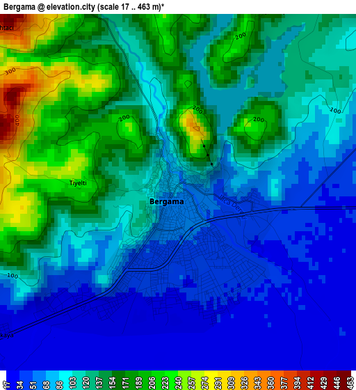
Below is the Elevation map of Bergama, which displays elevation range with different colors. Scale of the first map is from 17 to 463 m (56 to 1519 ft) with average elevation of 110.8 meters (=364 ft) [note 1]
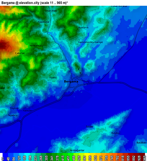
These maps also provides idea of topography and contour of this city, they are displayed at different zoom levels. More info about maps, scale and edge coordinates you can find below images.
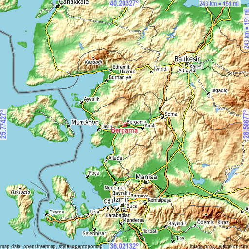
| \ | Map #1 | Map #2 | Topo.Map |
| Scale [m] | 17..463 m | 11..965 m | × |
| Scale [ft] | 56..1519 ft | 36..3166 ft | × |
| Average | 110.8 m = 364 ft | 155.8 m = 511 ft | × |
| Width | 7.58 km = 4.7 mi | 15.16 km = 9.4 mi | 242.6 km = 150.7 mi |
| Height | 7.58 km = 4.7 mi | 15.16 km = 9.4 mi | 242.6 km = 150.7 mi |
| ↑Max Latitude | 39.154825° | 39.188894° | 40.20327° |
| Latitude at center | 39.12074° | 39.12074° | 39.12074° |
| ↓Min Latitude | 39.086638° | 39.05252° | 38.02132° |
| ← Min Longitude | 27.136575° | 27.092629° | 25.77427° |
| Longitude center | 27.18052° | 27.18052° | 27.18052° |
| →Max Longitude | 27.224465° | 27.268411° | 28.58677° |
Nearby cities:
Cities around Bergama sort by population:
• Soma elevation 155 m
37.7 km,  78°
78°
• Aliağa 24 m
40 km,  206°
206°
• Dikili 8 m
25.7 km,  257°
257°
• Kınık 84 m
17.9 km,  102°
102°
• Çandarlı 4 m
29.7 km,  225°
225°
• Yenişakran 5 m
27.8 km,  200°
200°
• Zeytindağ 132 m
19.5 km, 208°
• Altınova 15 m
35.3 km,  287°
287°
• Göçbeyli 85 m
22.4 km,  59°
59°
• Turanlı 232 m
21.3 km,  35°
35°
• Yuntdağ 450 m
21.2 km,  172°
172°
• Kozak 500 m
16.5 km,  331°
331°
Multilingual:
 En español:
Pérgamo elevación 69 m.
 En France:
Pergame élévation 69 m.


Sources and notes:
- [note 1] Map square and city borders are not equal. Map elevation data is calculated only from area inside that square.
- [src 1] Elevation data from geonames database provided with same terms of usage.
- [src 2] The elevation map of Bergama is generated using elevation data from NASA's 3 arcsec (90m) resolution SRTM data.
- [src 3] Base (background) map © OpenStreetMap contributors tiles are generated by Geofabrik and OpenTopoMap.
Copyright & License:
This Bergama Elevation Map is licensed under CC BY-SA. You may reuse any part from this page, if you give a proper credit by linking to this URL:
 More info on terms of use page.