Beşiri elevation
Beşiri (Batman), Turkey elevation is 770 meters and Beşiri elevation in feet is 2526 ft above sea level [src 1]. Beşiri is a seat of a second-order administrative division (feature code) with elevation that is 47 meters (154 ft) bigger than average city elevation in Turkey.
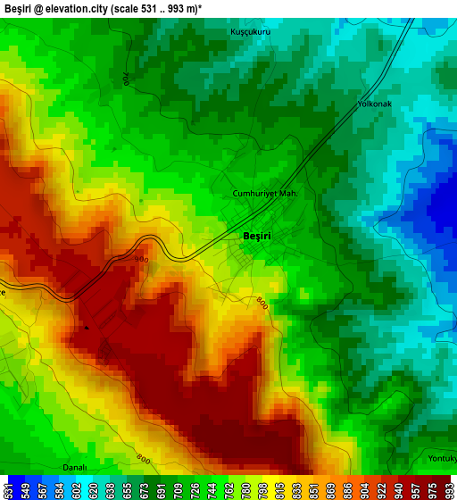
Below is the Elevation map of Beşiri, which displays elevation range with different colors. Scale of the first map is from 531 to 993 m (1742 to 3258 ft) with average elevation of 756.2 meters (=2481 ft) [note 1]
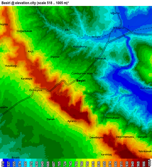
These maps also provides idea of topography and contour of this city, they are displayed at different zoom levels. More info about maps, scale and edge coordinates you can find below images.
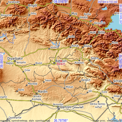
| \ | Map #1 | Map #2 | Topo.Map |
| Scale [m] | 531..993 m | 518..1005 m | × |
| Scale [ft] | 1742..3258 ft | 1699..3297 ft | × |
| Average | 756.2 m = 2481 ft | 717 m = 2352 ft | × |
| Width | 7.71 km = 4.8 mi | 15.42 km = 9.6 mi | 246.7 km = 153.3 mi |
| Height | 7.71 km = 4.8 mi | 15.42 km = 9.6 mi | 246.7 km = 153.3 mi |
| ↑Max Latitude | 37.950391° | 37.985036° | 39.01675° |
| Latitude at center | 37.91573° | 37.91573° | 37.91573° |
| ↓Min Latitude | 37.881053° | 37.846359° | 36.79798° |
| ← Min Longitude | 41.242555° | 41.198609° | 39.88025° |
| Longitude center | 41.2865° | 41.2865° | 41.2865° |
| →Max Longitude | 41.330445° | 41.374391° | 42.69275° |
Nearby cities:
Cities around Beşiri sort by population:
• Batman elevation 574 m
13.9 km,  256°
256°
• Aviski 567 m
6.7 km,  35°
35°
• Binatlı 640 m
9.8 km,  218°
218°
• Doğankavak 751 m
7.4 km,  314°
314°
• Demiryol 622 m
12 km,  270°
270°
• Çevrimova 717 m
8.5 km,  188°
188°
• Aydınkonak 622 m
11 km, 257°
• Taliban 575 m
13.3 km,  56°
56°
• Yenipınar 736 m
8.2 km,  170°
170°
• Erköklü 592 m
13.9 km,  244°
244°
• Oğuz 866 m
13.6 km,  145°
145°
• Beyçayırı 627 m
11.4 km,  16°
16°
Multilingual:
 En español:
Beşiri elevación 770 m.
 En France:
Beşiri élévation 770 m.


Sources and notes:
- [note 1] Map square and city borders are not equal. Map elevation data is calculated only from area inside that square.
- [src 1] Elevation data from geonames database provided with same terms of usage.
- [src 2] The elevation map of Beşiri is generated using elevation data from NASA's 3 arcsec (90m) resolution SRTM data.
- [src 3] Base (background) map © OpenStreetMap contributors tiles are generated by Geofabrik and OpenTopoMap.
Copyright & License:
This Beşiri Elevation Map is licensed under CC BY-SA. You may reuse any part from this page, if you give a proper credit by linking to this URL:
 More info on terms of use page.