Çevrimova elevation
Çevrimova (Batman), Turkey elevation is 717 meters and Çevrimova elevation in feet is 2352 ft above sea level [src 1]. Çevrimova is a populated place (feature code) with elevation that is 6 meters (20 ft) smaller than average city elevation in Turkey.
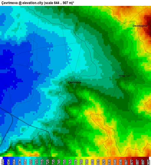
Below is the Elevation map of Çevrimova, which displays elevation range with different colors. Scale of the first map is from 644 to 907 m (2113 to 2976 ft) with average elevation of 724.2 meters (=2376 ft) [note 1]
These maps also provides idea of topography and contour of this city, they are displayed at different zoom levels. More info about maps, scale and edge coordinates you can find below images.
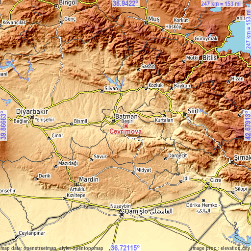
| \ | Map #1 | Topo.Map |
| Scale [m] | 644..907 m | × |
| Scale [ft] | 2113..2976 ft | × |
| Average | 724.2 m = 2376 ft | × |
| Width | 7.72 km = 4.8 mi | 247 km = 153.5 mi |
| Height | 7.72 km = 4.8 mi | 247 km = 153.5 mi |
| ↑Max Latitude | 37.874727° | 38.9422° |
| Latitude at center | 37.84003° | 37.84003° |
| ↓Min Latitude | 37.805317° | 36.72115° |
| ← Min Longitude | 41.228935° | 39.86663° |
| Longitude center | 41.27288° | 41.27288° |
| →Max Longitude | 41.316825° | 42.67913° |
Nearby cities:
Cities around Çevrimova sort by population:
• Batman elevation 574 m
13.4 km,  293°
293°
• Beşiri 770 m
8.5 km,  8°
8°
• Aviski 567 m
14.8 km,  20°
20°
• Hasankeyf 564 m
18.9 km,  142°
142°
• Balpınar 538 m
19.3 km,  279°
279°
• Binatlı 640 m
5 km, 278°
• Doğankavak 751 m
14.2 km,  343°
343°
• Demiryol 622 m
13.8 km,  308°
308°
• Aydınkonak 622 m
11.3 km,  302°
302°
• Yenipınar 736 m
2.5 km,  82°
82°
• Erköklü 592 m
11.6 km, 282°
• Oğuz 866 m
9.3 km,  107°
107°
Multilingual:
 En español:
Çevrimova elevación 717 m.
 En France:
Çevrimova élévation 717 m.
 Auf Deutsch:
Çevrimova höhe über dem Meeresspiegel ist 717 m.

Sources and notes:
- [note 1] Map square and city borders are not equal. Map elevation data is calculated only from area inside that square.
- [src 1] Elevation data from geonames database provided with same terms of usage.
- [src 2] The elevation map of Çevrimova is generated using elevation data from NASA's 3 arcsec (90m) resolution SRTM data.
- [src 3] Base (background) map © OpenStreetMap contributors tiles are generated by Geofabrik and OpenTopoMap.
Copyright & License:
This Çevrimova Elevation Map is licensed under CC BY-SA. You may reuse any part from this page, if you give a proper credit by linking to this URL:
 More info on terms of use page.