Beytüşşebap elevation
Beytüşşebap (Şırnak), Turkey elevation is 1475 meters and Beytüşşebap elevation in feet is 4839 ft above sea level [src 1]. Beytüşşebap is a seat of a second-order administrative division (feature code) with elevation that is 752 meters (2467 ft) bigger than average city elevation in Turkey.
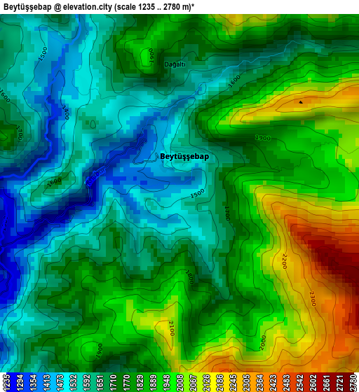
Below is the Elevation map of Beytüşşebap, which displays elevation range with different colors. Scale of the first map is from 1235 to 2780 m (4052 to 9121 ft) with average elevation of 1778.7 meters (=5836 ft) [note 1]
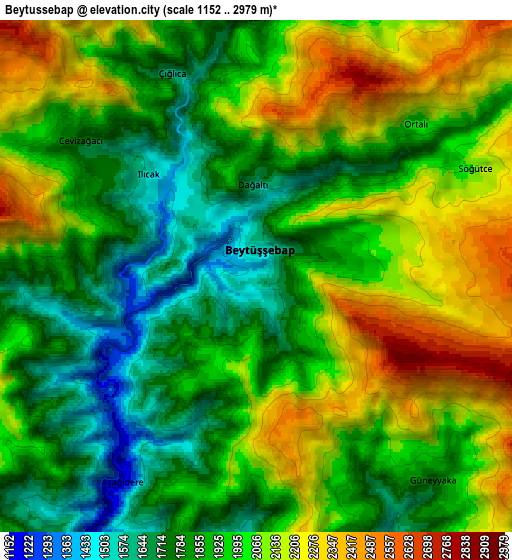
These maps also provides idea of topography and contour of this city, they are displayed at different zoom levels. More info about maps, scale and edge coordinates you can find below images.
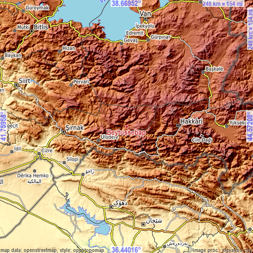
| \ | Map #1 | Map #2 | Topo.Map |
| Scale [m] | 1235..2780 m | 1152..2979 m | × |
| Scale [ft] | 4052..9121 ft | 3780..9774 ft | × |
| Average | 1778.7 m = 5836 ft | 1973.8 m = 6476 ft | × |
| Width | 7.75 km = 4.8 mi | 15.49 km = 9.6 mi | 247.9 km = 154 mi |
| Height | 7.75 km = 4.8 mi | 15.49 km = 9.6 mi | 247.9 km = 154 mi |
| ↑Max Latitude | 37.598006° | 37.632817° | 38.66952° |
| Latitude at center | 37.56318° | 37.56318° | 37.56318° |
| ↓Min Latitude | 37.528337° | 37.493478° | 36.44016° |
| ← Min Longitude | 43.121885° | 43.077939° | 41.75958° |
| Longitude center | 43.16583° | 43.16583° | 43.16583° |
| →Max Longitude | 43.209775° | 43.253721° | 44.57208° |
Nearby cities:
Cities around Beytüşşebap sort by population:
• Uludere elevation 1346 m
30.8 km,  243°
243°
• Uzungeçit 1541 m
17.5 km, 242°
• Mezraa 2038 m
11.2 km,  10°
10°
• Becuh 1366 m
24.6 km,  219°
219°
• Andaç 1334 m
24.7 km,  159°
159°
• Yemişli 1201 m
23.2 km,  199°
199°
• Ortabağ 1326 m
29.2 km,  230°
230°
• Başaran 1156 m
10.1 km, 198°
• Boğazören 1514 m
14.5 km,  254°
254°
• Ballı 1144 m
33.3 km, 239°
• Ortaköy 1418 m
28.2 km, 158°
• Ashuta 1732 m
32.5 km,  145°
145°
Multilingual:
 En español:
Beytüşşebap elevación 1475 m.
 En France:
Beytüşşebap élévation 1475 m.
 Auf Deutsch:
Beytüşşebap höhe über dem Meeresspiegel ist 1475 m.

Sources and notes:
- [note 1] Map square and city borders are not equal. Map elevation data is calculated only from area inside that square.
- [src 1] Elevation data from geonames database provided with same terms of usage.
- [src 2] The elevation map of Beytüşşebap is generated using elevation data from NASA's 3 arcsec (90m) resolution SRTM data.
- [src 3] Base (background) map © OpenStreetMap contributors tiles are generated by Geofabrik and OpenTopoMap.
Copyright & License:
This Beytüşşebap Elevation Map is licensed under CC BY-SA. You may reuse any part from this page, if you give a proper credit by linking to this URL:
 More info on terms of use page.