Çatalarmut elevation
Çatalarmut (Erzincan), Turkey elevation is 1431 meters and Çatalarmut elevation in feet is 4695 ft above sea level [src 1]. Çatalarmut is a seat of a third-order administrative division (feature code) with elevation that is 708 meters (2323 ft) bigger than average city elevation in Turkey.
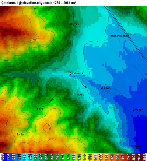
Below is the Elevation map of Çatalarmut, which displays elevation range with different colors. Scale of the first map is from 1274 to 2064 m (4180 to 6772 ft) with average elevation of 1548.7 meters (=5081 ft) [note 1]
These maps also provides idea of topography and contour of this city, they are displayed at different zoom levels. More info about maps, scale and edge coordinates you can find below images.
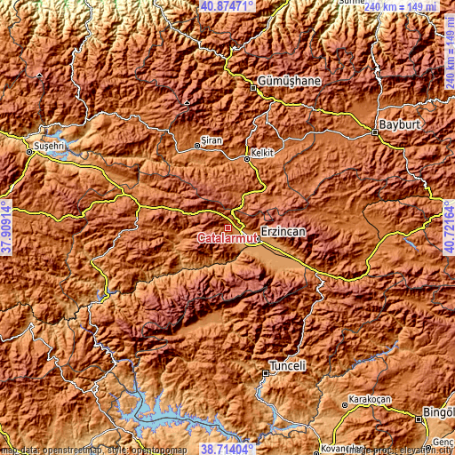
| \ | Map #1 | Topo.Map |
| Scale [m] | 1274..2064 m | × |
| Scale [ft] | 4180..6772 ft | × |
| Average | 1548.7 m = 5081 ft | × |
| Width | 7.51 km = 4.7 mi | 240.2 km = 149.3 mi |
| Height | 7.51 km = 4.7 mi | 240.2 km = 149.3 mi |
| ↑Max Latitude | 39.836613° | 40.87471° |
| Latitude at center | 39.80286° | 39.80286° |
| ↓Min Latitude | 39.769091° | 38.71404° |
| ← Min Longitude | 39.271445° | 37.90914° |
| Longitude center | 39.31539° | 39.31539° |
| →Max Longitude | 39.359335° | 40.72164° |
Nearby cities:
Cities around Çatalarmut sort by population:
• Erzincan elevation 1195 m
16.5 km,  115°
115°
• Cimin 1422 m
34.5 km,  107°
107°
• Kelkit 1414 m
37.4 km,  15°
15°
• Şiran 1424 m
46.3 km,  338°
338°
• Refahiye 1598 m
48 km,  282°
282°
• Kemah 1092 m
34 km,  227°
227°
• Başköy 1803 m
45.6 km,  80°
80°
• Çatalçam 1632 m
44.2 km,  295°
295°
• Çağlayan 1541 m
40 km,  127°
127°
• Cengerli 1628 m
39.9 km,  268°
268°
• Doğanbeyli 1517 m
26.8 km,  243°
243°
• Alpköy 1075 m
23.7 km,  207°
207°
Multilingual:
 En español:
Çatalarmut elevación 1431 m.
 En France:
Çatalarmut élévation 1431 m.
 Auf Deutsch:
Çatalarmut höhe über dem Meeresspiegel ist 1431 m.

Sources and notes:
- [note 1] Map square and city borders are not equal. Map elevation data is calculated only from area inside that square.
- [src 1] Elevation data from geonames database provided with same terms of usage.
- [src 2] The elevation map of Çatalarmut is generated using elevation data from NASA's 3 arcsec (90m) resolution SRTM data.
- [src 3] Base (background) map © OpenStreetMap contributors tiles are generated by Geofabrik and OpenTopoMap.
Copyright & License:
This Çatalarmut Elevation Map is licensed under CC BY-SA. You may reuse any part from this page, if you give a proper credit by linking to this URL:
 More info on terms of use page.