Cimin elevation
Cimin (Erzincan), Turkey elevation is 1422 meters and Cimin elevation in feet is 4665 ft above sea level [src 1]. Cimin is a seat of a second-order administrative division (feature code) with elevation that is 699 meters (2293 ft) bigger than average city elevation in Turkey.
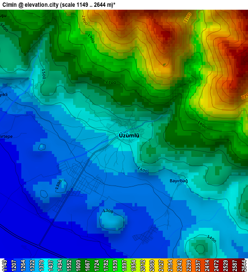
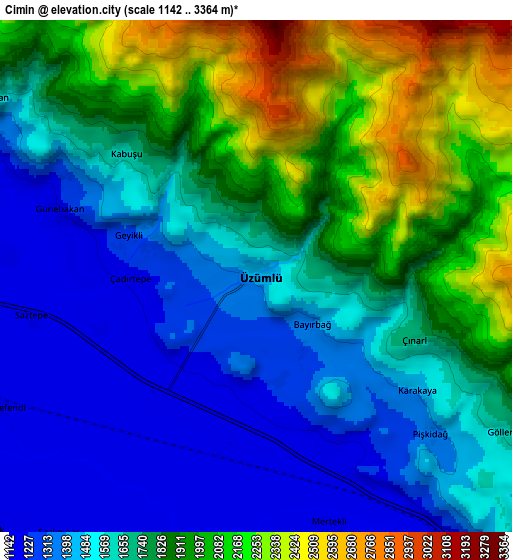
Below is the Elevation map of Cimin, which displays elevation range with different colors. Scale of the first map is from 1149 to 2644 m (3770 to 8675 ft) with average elevation of 1565 meters (=5135 ft) [note 1]
These maps also provides idea of topography and contour of this city, they are displayed at different zoom levels. More info about maps, scale and edge coordinates you can find below images.
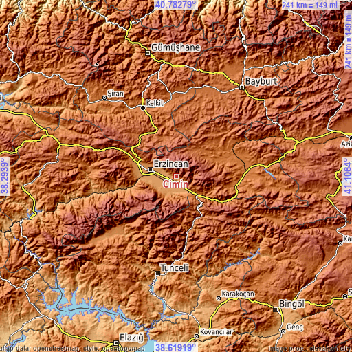
| \ | Map #1 | Map #2 | Topo.Map |
| Scale [m] | 1149..2644 m | 1142..3364 m | × |
| Scale [ft] | 3770..8675 ft | 3747..11037 ft | × |
| Average | 1565 m = 5135 ft | 1706.6 m = 5599 ft | × |
| Width | 7.52 km = 4.7 mi | 15.04 km = 9.3 mi | 240.6 km = 149.5 mi |
| Height | 7.52 km = 4.7 mi | 15.04 km = 9.3 mi | 240.6 km = 149.5 mi |
| ↑Max Latitude | 39.743269° | 39.777051° | 40.78279° |
| Latitude at center | 39.70947° | 39.70947° | 39.70947° |
| ↓Min Latitude | 39.675655° | 39.641823° | 38.61919° |
| ← Min Longitude | 39.656205° | 39.612259° | 38.2939° |
| Longitude center | 39.70015° | 39.70015° | 39.70015° |
| →Max Longitude | 39.744095° | 39.788041° | 41.1064° |
Nearby cities:
Cities around Cimin sort by population:
• Erzincan elevation 1195 m
18.3 km,  280°
280°
• Turluk 1646 m
33.6 km,  153°
153°
• Otlukbeli 1735 m
39.7 km,  43°
43°
• Pulumer 1499 m
30.1 km, 146°
• Üçdam 1585 m
43.9 km,  111°
111°
• Mezraa 1413 m
37.5 km,  163°
163°
• Çatalarmut 1431 m
34.5 km,  287°
287°
• Çayırlı 1532 m
30.1 km,  68°
68°
• Dağyolu 1774 m
26 km,  136°
136°
• Başköy 1803 m
21.8 km,  33°
33°
• Tanyeri 1221 m
15.7 km,  134°
134°
• Çağlayan 1541 m
13.9 km,  184°
184°
Multilingual:
 En español:
Cimin elevación 1422 m.
 En France:
Cimin élévation 1422 m.


Sources and notes:
- [note 1] Map square and city borders are not equal. Map elevation data is calculated only from area inside that square.
- [src 1] Elevation data from geonames database provided with same terms of usage.
- [src 2] The elevation map of Cimin is generated using elevation data from NASA's 3 arcsec (90m) resolution SRTM data.
- [src 3] Base (background) map © OpenStreetMap contributors tiles are generated by Geofabrik and OpenTopoMap.
Copyright & License:
This Cimin Elevation Map is licensed under CC BY-SA. You may reuse any part from this page, if you give a proper credit by linking to this URL:
 More info on terms of use page.