Gelendost elevation
Gelendost (Isparta), Turkey elevation is 951 meters and Gelendost elevation in feet is 3120 ft above sea level [src 1]. Gelendost is a seat of a second-order administrative division (feature code) with elevation that is 228 meters (748 ft) bigger than average city elevation in Turkey.
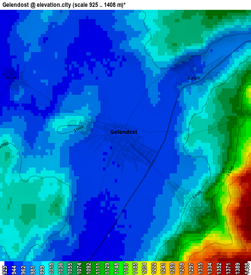
Below is the Elevation map of Gelendost, which displays elevation range with different colors. Scale of the first map is from 925 to 1408 m (3035 to 4619 ft) with average elevation of 1001.9 meters (=3287 ft) [note 1]
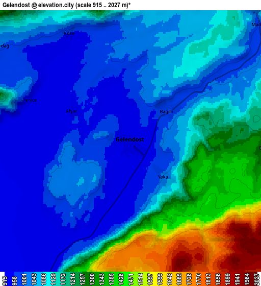
These maps also provides idea of topography and contour of this city, they are displayed at different zoom levels. More info about maps, scale and edge coordinates you can find below images.
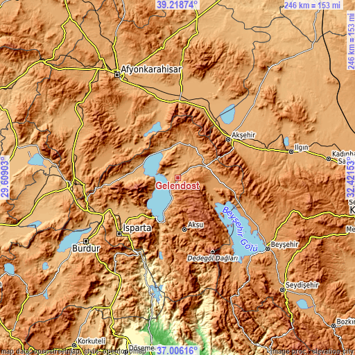
| \ | Map #1 | Map #2 | Topo.Map |
| Scale [m] | 925..1408 m | 915..2027 m | × |
| Scale [ft] | 3035..4619 ft | 3002..6650 ft | × |
| Average | 1001.9 m = 3287 ft | 1126.4 m = 3696 ft | × |
| Width | 7.69 km = 4.8 mi | 15.38 km = 9.6 mi | 246 km = 152.9 mi |
| Height | 7.69 km = 4.8 mi | 15.38 km = 9.6 mi | 246 km = 152.9 mi |
| ↑Max Latitude | 38.155394° | 38.189942° | 39.21874° |
| Latitude at center | 38.12083° | 38.12083° | 38.12083° |
| ↓Min Latitude | 38.08625° | 38.051653° | 37.00616° |
| ← Min Longitude | 30.971335° | 30.927389° | 29.60903° |
| Longitude center | 31.01528° | 31.01528° | 31.01528° |
| →Max Longitude | 31.059225° | 31.103171° | 32.42153° |
Nearby cities:
Cities around Gelendost sort by population:
• Akşehir elevation 1033 m
43.8 km,  53°
53°
• Yalvaç 1100 m
24.1 km,  36°
36°
• Şarkîkaraağaç 1170 m
31.1 km,  98°
98°
• Eğirdir 925 m
31 km,  207°
207°
• Senirkent 1024 m
40.9 km,  267°
267°
• Gönen 1040 m
47.8 km,  247°
247°
• Atabey 1039 m
38 km,  240°
240°
• Aksu 1229 m
36.1 km,  172°
172°
• Anamas 2130 m
43.7 km, 205°
• Bağkonak 1156 m
24.9 km,  64°
64°
• Barla 1108 m
23.4 km, 240°
• Kumdanlı 1012 m
22.8 km,  351°
351°
Multilingual:
 En español:
Gelendost elevación 951 m.
 En France:
Gelendost élévation 951 m.
 Auf Deutsch:
Gelendost höhe über dem Meeresspiegel ist 951 m.

Sources and notes:
- [note 1] Map square and city borders are not equal. Map elevation data is calculated only from area inside that square.
- [src 1] Elevation data from geonames database provided with same terms of usage.
- [src 2] The elevation map of Gelendost is generated using elevation data from NASA's 3 arcsec (90m) resolution SRTM data.
- [src 3] Base (background) map © OpenStreetMap contributors tiles are generated by Geofabrik and OpenTopoMap.
Copyright & License:
This Gelendost Elevation Map is licensed under CC BY-SA. You may reuse any part from this page, if you give a proper credit by linking to this URL:
 More info on terms of use page.