Ilgın elevation
Ilgın (Konya), Turkey elevation is 1036 meters and Ilgın elevation in feet is 3399 ft above sea level [src 1]. Ilgın is a seat of a second-order administrative division (feature code) with elevation that is 313 meters (1027 ft) bigger than average city elevation in Turkey.
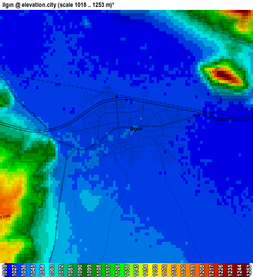
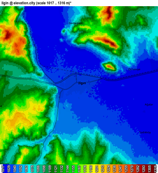
Below is the Elevation map of Ilgın, which displays elevation range with different colors. Scale of the first map is from 1018 to 1253 m (3340 to 4111 ft) with average elevation of 1046.3 meters (=3433 ft) [note 1]
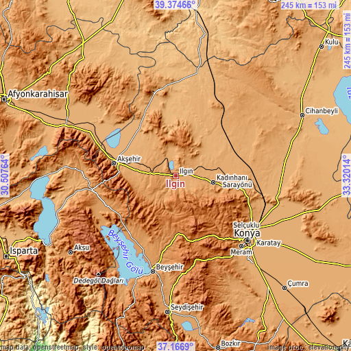
These maps also provides idea of topography and contour of this city, they are displayed at different zoom levels. More info about maps, scale and edge coordinates you can find below images.
| \ | Map #1 | Map #2 | Topo.Map |
| Scale [m] | 1018..1253 m | 1017..1316 m | × |
| Scale [ft] | 3340..4111 ft | 3337..4318 ft | × |
| Average | 1046.3 m = 3433 ft | 1081.5 m = 3548 ft | × |
| Width | 7.67 km = 4.8 mi | 15.34 km = 9.5 mi | 245.5 km = 152.5 mi |
| Height | 7.67 km = 4.8 mi | 15.34 km = 9.5 mi | 245.5 km = 152.5 mi |
| ↑Max Latitude | 38.313659° | 38.348131° | 39.37466° |
| Latitude at center | 38.27917° | 38.27917° | 38.27917° |
| ↓Min Latitude | 38.244665° | 38.210143° | 37.1669° |
| ← Min Longitude | 31.869945° | 31.825999° | 30.50764° |
| Longitude center | 31.91389° | 31.91389° | 31.91389° |
| →Max Longitude | 31.957835° | 32.001781° | 33.32014° |
Nearby cities:
Cities around Ilgın sort by population:
• Akşehir elevation 1033 m
44.3 km,  281°
281°
• Kadınhanı 1121 m
26.3 km,  99°
99°
• Hüyük 1249 m
45.6 km,  217°
217°
• Sarayönü 1062 m
42.9 km,  92°
92°
• Doğanhisar 1200 m
25.5 km,  234°
234°
• Derbent 1489 m
30.8 km,  163°
163°
• Tuzlukçu 993 m
33.4 km,  311°
311°
• Turgut 1004 m
39.7 km,  346°
346°
• Reis 1078 m
29.9 km,  268°
268°
• Aşağıçiğil 1243 m
25.7 km,  189°
189°
• Kurthasanlı 1029 m
23.4 km,  77°
77°
• Argıthanı 1094 m
17.5 km, 274°
Multilingual:
 En español:
Ilgın elevación 1036 m.
 En France:
Ilgın élévation 1036 m.


Sources and notes:
- [note 1] Map square and city borders are not equal. Map elevation data is calculated only from area inside that square.
- [src 1] Elevation data from geonames database provided with same terms of usage.
- [src 2] The elevation map of Ilgın is generated using elevation data from NASA's 3 arcsec (90m) resolution SRTM data.
- [src 3] Base (background) map © OpenStreetMap contributors tiles are generated by Geofabrik and OpenTopoMap.
Copyright & License:
This Ilgın Elevation Map is licensed under CC BY-SA. You may reuse any part from this page, if you give a proper credit by linking to this URL:
 More info on terms of use page.