Tuzlukçu elevation
Tuzlukçu (Konya), Turkey elevation is 993 meters and Tuzlukçu elevation in feet is 3258 ft above sea level [src 1]. Tuzlukçu is a seat of a second-order administrative division (feature code) with elevation that is 270 meters (886 ft) bigger than average city elevation in Turkey.
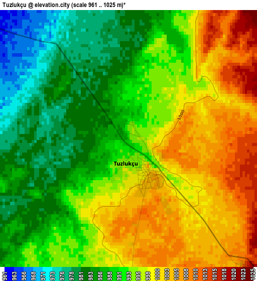
Below is the Elevation map of Tuzlukçu, which displays elevation range with different colors. Scale of the first map is from 961 to 1025 m (3153 to 3363 ft) with average elevation of 993.1 meters (=3258 ft) [note 1]
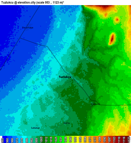
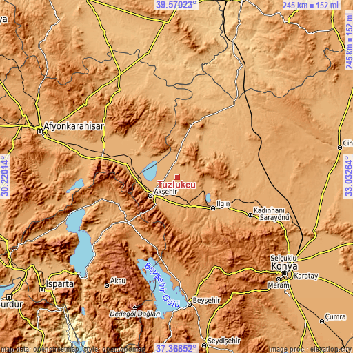
These maps also provides idea of topography and contour of this city, they are displayed at different zoom levels. More info about maps, scale and edge coordinates you can find below images.
| \ | Map #1 | Map #2 | Topo.Map |
| Scale [m] | 961..1025 m | 953..1123 m | × |
| Scale [ft] | 3153..3363 ft | 3127..3684 ft | × |
| Average | 993.1 m = 3258 ft | 997.9 m = 3274 ft | × |
| Width | 7.65 km = 4.8 mi | 15.3 km = 9.5 mi | 244.8 km = 152.1 mi |
| Height | 7.65 km = 4.8 mi | 15.3 km = 9.5 mi | 244.8 km = 152.1 mi |
| ↑Max Latitude | 38.512174° | 38.546552° | 39.57023° |
| Latitude at center | 38.47778° | 38.47778° | 38.47778° |
| ↓Min Latitude | 38.443369° | 38.408942° | 37.36852° |
| ← Min Longitude | 31.582445° | 31.538499° | 30.22014° |
| Longitude center | 31.62639° | 31.62639° | 31.62639° |
| →Max Longitude | 31.670335° | 31.714281° | 33.03264° |
Nearby cities:
Cities around Tuzlukçu sort by population:
• Akşehir elevation 1033 m
22.7 km,  233°
233°
• Yalvaç 1100 m
44 km,  242°
242°
• Şarkîkaraağaç 1170 m
49.8 km,  207°
207°
• Ilgın 1036 m
33.4 km,  131°
131°
• Yunak 1088 m
38.5 km,  13°
13°
• Doğanhisar 1200 m
37.1 km,  173°
173°
• Sultandağı 1017 m
35.2 km,  279°
279°
• Kurthasanlı 1029 m
50.7 km,  109°
109°
• Bağkonak 1156 m
42.3 km, 226°
• Reis 1078 m
23.4 km,  191°
191°
• Turgut 1004 m
23.1 km,  44°
44°
• Argıthanı 1094 m
22 km,  159°
159°
Multilingual:
 En español:
Tuzlukçu elevación 993 m.
 En France:
Tuzlukçu élévation 993 m.
 Auf Deutsch:
Tuzlukçu höhe über dem Meeresspiegel ist 993 m.

Sources and notes:
- [note 1] Map square and city borders are not equal. Map elevation data is calculated only from area inside that square.
- [src 1] Elevation data from geonames database provided with same terms of usage.
- [src 2] The elevation map of Tuzlukçu is generated using elevation data from NASA's 3 arcsec (90m) resolution SRTM data.
- [src 3] Base (background) map © OpenStreetMap contributors tiles are generated by Geofabrik and OpenTopoMap.
Copyright & License:
This Tuzlukçu Elevation Map is licensed under CC BY-SA. You may reuse any part from this page, if you give a proper credit by linking to this URL:
 More info on terms of use page.