Kayapınar elevation
Kayapınar (Diyarbakır), Turkey elevation is 728 meters and Kayapınar elevation in feet is 2388 ft above sea level [src 1]. Kayapınar is a seat of a second-order administrative division (feature code) with elevation that is 5 meters (16 ft) bigger than average city elevation in Turkey.
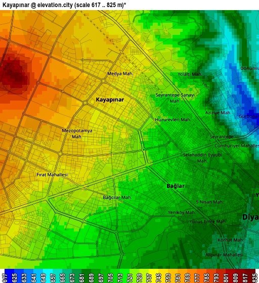
Below is the Elevation map of Kayapınar, which displays elevation range with different colors. Scale of the first map is from 617 to 825 m (2024 to 2707 ft) with average elevation of 721.1 meters (=2366 ft) [note 1]
These maps also provides idea of topography and contour of this city, they are displayed at different zoom levels. More info about maps, scale and edge coordinates you can find below images.
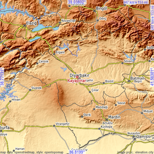
| \ | Map #1 | Topo.Map |
| Scale [m] | 617..825 m | × |
| Scale [ft] | 2024..2707 ft | × |
| Average | 721.1 m = 2366 ft | × |
| Width | 7.71 km = 4.8 mi | 246.6 km = 153.2 mi |
| Height | 7.71 km = 4.8 mi | 246.6 km = 153.2 mi |
| ↑Max Latitude | 37.971981° | 39.03802° |
| Latitude at center | 37.93733° | 37.93733° |
| ↓Min Latitude | 37.902663° | 36.8199° |
| ← Min Longitude | 40.133615° | 38.77131° |
| Longitude center | 40.17756° | 40.17756° |
| →Max Longitude | 40.221505° | 41.58381° |
Nearby cities:
Cities around Kayapınar sort by population:
• Diyarbakır elevation 674 m
4.4 km,  127°
127°
• Ambar 562 m
32.1 km,  106°
106°
• Eğil 861 m
36.7 km,  345°
345°
• Kerh 577 m
34.5 km, 111°
• Ahmetli 791 m
38.8 km,  313°
313°
• Çınar 658 m
31.3 km,  139°
139°
• Mermer 752 m
31.1 km,  49°
49°
• Ovabağ 1033 m
30.5 km,  213°
213°
• Yolboyu 846 m
16.1 km,  254°
254°
• Sur 669 m
5.2 km,  120°
120°
• Bağlar 684 m
3.6 km, 136°
• Yenişehir 766 m
3.5 km,  277°
277°
Multilingual:
 En español:
Kayapınar elevación 728 m.
 En France:
Kayapınar élévation 728 m.
 Auf Deutsch:
Kayapınar höhe über dem Meeresspiegel ist 728 m.

Sources and notes:
- [note 1] Map square and city borders are not equal. Map elevation data is calculated only from area inside that square.
- [src 1] Elevation data from geonames database provided with same terms of usage.
- [src 2] The elevation map of Kayapınar is generated using elevation data from NASA's 3 arcsec (90m) resolution SRTM data.
- [src 3] Base (background) map © OpenStreetMap contributors tiles are generated by Geofabrik and OpenTopoMap.
Copyright & License:
This Kayapınar Elevation Map is licensed under CC BY-SA. You may reuse any part from this page, if you give a proper credit by linking to this URL:
 More info on terms of use page.