Ambar elevation
Ambar (Diyarbakır), Turkey elevation is 562 meters and Ambar elevation in feet is 1844 ft above sea level [src 1]. Ambar is a populated place (feature code) with elevation that is 161 meters (528 ft) smaller than average city elevation in Turkey.
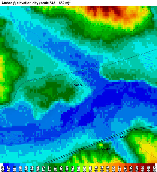
Below is the Elevation map of Ambar, which displays elevation range with different colors. Scale of the first map is from 543 to 652 m (1781 to 2139 ft) with average elevation of 568.1 meters (=1864 ft) [note 1]
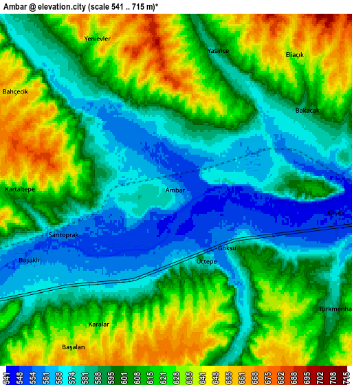
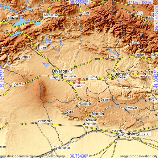
These maps also provides idea of topography and contour of this city, they are displayed at different zoom levels. More info about maps, scale and edge coordinates you can find below images.
| \ | Map #1 | Map #2 | Topo.Map |
| Scale [m] | 543..652 m | 541..715 m | × |
| Scale [ft] | 1781..2139 ft | 1775..2346 ft | × |
| Average | 568.1 m = 1864 ft | 602.4 m = 1976 ft | × |
| Width | 7.72 km = 4.8 mi | 15.43 km = 9.6 mi | 246.9 km = 153.4 mi |
| Height | 7.72 km = 4.8 mi | 15.43 km = 9.6 mi | 246.9 km = 153.4 mi |
| ↑Max Latitude | 37.88774° | 37.922415° | 38.95502° |
| Latitude at center | 37.85305° | 37.85305° | 37.85305° |
| ↓Min Latitude | 37.818343° | 37.78362° | 36.73436° |
| ← Min Longitude | 40.484035° | 40.440089° | 39.12173° |
| Longitude center | 40.52798° | 40.52798° | 40.52798° |
| →Max Longitude | 40.571925° | 40.615871° | 41.93423° |
Nearby cities:
Cities around Ambar sort by population:
• Diyarbakır elevation 674 m
28.1 km,  283°
283°
• Bismil 543 m
11.6 km,  94°
94°
• Kerh 577 m
3.4 km,  155°
155°
• Aralık 542 m
13.6 km,  101°
101°
• Şenocak 810 m
26.9 km,  147°
147°
• Yaprakbaşı 753 m
22.2 km,  175°
175°
• Kazancı 641 m
11.1 km, 145°
• Köseli 550 m
7.2 km, 102°
• Kavsan 790 m
24.7 km, 152°
• Sur 669 m
27.1 km, 284°
• Tepe 541 m
22.5 km,  108°
108°
• Çınar 658 m
18 km,  216°
216°
Multilingual:
 En español:
Ambar elevación 562 m.
 En France:
Ambar élévation 562 m.


Sources and notes:
- [note 1] Map square and city borders are not equal. Map elevation data is calculated only from area inside that square.
- [src 1] Elevation data from geonames database provided with same terms of usage.
- [src 2] The elevation map of Ambar is generated using elevation data from NASA's 3 arcsec (90m) resolution SRTM data.
- [src 3] Base (background) map © OpenStreetMap contributors tiles are generated by Geofabrik and OpenTopoMap.
Copyright & License:
This Ambar Elevation Map is licensed under CC BY-SA. You may reuse any part from this page, if you give a proper credit by linking to this URL:
 More info on terms of use page.