Musabeyli elevation
Musabeyli (Kilis), Turkey elevation is 756 meters and Musabeyli elevation in feet is 2480 ft above sea level [src 1]. Musabeyli is a seat of a second-order administrative division (feature code) with elevation that is 33 meters (108 ft) bigger than average city elevation in Turkey.
Below is the Elevation map of Musabeyli, which displays elevation range with different colors. Scale of the first map is from 504 to 915 m (1654 to 3002 ft) with average elevation of 659.1 meters (=2162 ft) [note 1]
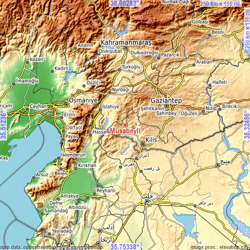
These maps also provides idea of topography and contour of this city, they are displayed at different zoom levels. More info about maps, scale and edge coordinates you can find below images.
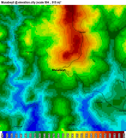
| \ | Map #1 | Topo.Map |
| Scale [m] | 504..915 m | × |
| Scale [ft] | 1654..3002 ft | × |
| Average | 659.1 m = 2162 ft | × |
| Width | 7.82 km = 4.9 mi | 250.1 km = 155.4 mi |
| Height | 7.82 km = 4.9 mi | 250.1 km = 155.4 mi |
| ↑Max Latitude | 36.921531° | 38.00283° |
| Latitude at center | 36.88639° | 36.88639° |
| ↓Min Latitude | 36.851233° | 35.75338° |
| ← Min Longitude | 36.874665° | 35.51236° |
| Longitude center | 36.91861° | 36.91861° |
| →Max Longitude | 36.962555° | 38.32486° |
Nearby cities:
Cities around Musabeyli sort by population:
• Kilis elevation 660 m
25.8 km,  137°
137°
• Nurdağı 486 m
35.3 km,  332°
332°
• Hassa 431 m
37 km,  254°
254°
• Hasanbeyli 723 m
42.6 km,  309°
309°
• Aşağı Karafakılı 348 m
34.3 km, 249°
• Aktepe 283 m
43.7 km,  241°
241°
• Şahinbey 883 m
41.8 km,  64°
64°
• Fevzipaşa 549 m
34 km, 312°
• Sakçagöz 694 m
31.7 km,  359°
359°
• İslahiye 523 m
29.9 km,  301°
301°
• Burç 909 m
27.1 km, 58°
• Polateli 844 m
20.7 km,  104°
104°
Multilingual:
 En español:
Musabeyli elevación 756 m.
 En France:
Musabeyli élévation 756 m.
 Auf Deutsch:
Musabeyli höhe über dem Meeresspiegel ist 756 m.

Sources and notes:
- [note 1] Map square and city borders are not equal. Map elevation data is calculated only from area inside that square.
- [src 1] Elevation data from geonames database provided with same terms of usage.
- [src 2] The elevation map of Musabeyli is generated using elevation data from NASA's 3 arcsec (90m) resolution SRTM data.
- [src 3] Base (background) map © OpenStreetMap contributors tiles are generated by Geofabrik and OpenTopoMap.
Copyright & License:
This Musabeyli Elevation Map is licensed under CC BY-SA. You may reuse any part from this page, if you give a proper credit by linking to this URL:
 More info on terms of use page.