Pasinler elevation
Pasinler (Erzurum), Turkey elevation is 1663 meters and Pasinler elevation in feet is 5456 ft above sea level [src 1]. Pasinler is a seat of a second-order administrative division (feature code) with elevation that is 940 meters (3084 ft) bigger than average city elevation in Turkey.
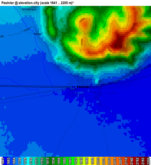
Below is the Elevation map of Pasinler, which displays elevation range with different colors. Scale of the first map is from 1641 to 2205 m (5384 to 7234 ft) with average elevation of 1740.5 meters (=5710 ft) [note 1]
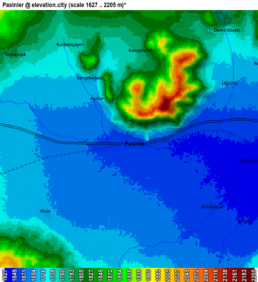
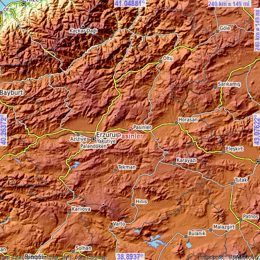
These maps also provides idea of topography and contour of this city, they are displayed at different zoom levels. More info about maps, scale and edge coordinates you can find below images.
| \ | Map #1 | Map #2 | Topo.Map |
| Scale [m] | 1641..2205 m | 1627..2205 m | × |
| Scale [ft] | 5384..7234 ft | 5338..7234 ft | × |
| Average | 1740.5 m = 5710 ft | 1731.1 m = 5679 ft | × |
| Width | 7.49 km = 4.7 mi | 14.98 km = 9.3 mi | 239.6 km = 148.9 mi |
| Height | 7.49 km = 4.7 mi | 14.98 km = 9.3 mi | 239.6 km = 148.9 mi |
| ↑Max Latitude | 40.013416° | 40.047065° | 41.04881° |
| Latitude at center | 39.97975° | 39.97975° | 39.97975° |
| ↓Min Latitude | 39.946068° | 39.912369° | 38.8937° |
| ← Min Longitude | 41.626025° | 41.582079° | 40.26372° |
| Longitude center | 41.66997° | 41.66997° | 41.66997° |
| →Max Longitude | 41.713915° | 41.757861° | 43.07622° |
Nearby cities:
Cities around Pasinler sort by population:
• Erzurum elevation 1914 m
34.4 km,  256°
256°
• Horasan 1556 m
42.6 km,  81°
81°
• Narman 1672 m
43.7 km,  21°
21°
• Tortum 1819 m
36.1 km,  342°
342°
• Tekman 1905 m
40.2 km,  200°
200°
• Dadaşköy 1782 m
35.6 km, 263°
• Yakutiye 1938 m
35.4 km, 255°
• Palandöken 1997 m
34.7 km,  253°
253°
• Kazımkarabekir 1889 m
33.9 km, 257°
• Dumlu 1778 m
28.1 km,  288°
288°
• Söylemez 1864 m
26.8 km,  155°
155°
• Köprüköy 1599 m
17 km,  95°
95°
Multilingual:
 En español:
Pasinler elevación 1663 m.
 En France:
Pasinler élévation 1663 m.
 Auf Deutsch:
Pasinler höhe über dem Meeresspiegel ist 1663 m.

Sources and notes:
- [note 1] Map square and city borders are not equal. Map elevation data is calculated only from area inside that square.
- [src 1] Elevation data from geonames database provided with same terms of usage.
- [src 2] The elevation map of Pasinler is generated using elevation data from NASA's 3 arcsec (90m) resolution SRTM data.
- [src 3] Base (background) map © OpenStreetMap contributors tiles are generated by Geofabrik and OpenTopoMap.
Copyright & License:
This Pasinler Elevation Map is licensed under CC BY-SA. You may reuse any part from this page, if you give a proper credit by linking to this URL:
 More info on terms of use page.