Tekman elevation
Tekman (Erzurum), Turkey elevation is 1905 meters and Tekman elevation in feet is 6250 ft above sea level [src 1]. Tekman is a seat of a second-order administrative division (feature code) with elevation that is 1182 meters (3878 ft) bigger than average city elevation in Turkey.
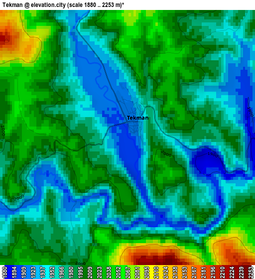
Below is the Elevation map of Tekman, which displays elevation range with different colors. Scale of the first map is from 1880 to 2253 m (6168 to 7392 ft) with average elevation of 1989.3 meters (=6527 ft) [note 1]
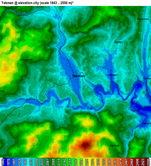
These maps also provides idea of topography and contour of this city, they are displayed at different zoom levels. More info about maps, scale and edge coordinates you can find below images.
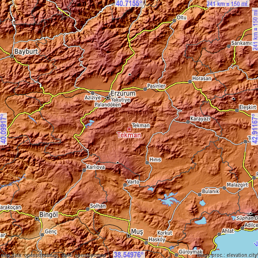
| \ | Map #1 | Map #2 | Topo.Map |
| Scale [m] | 1880..2253 m | 1843..2550 m | × |
| Scale [ft] | 6168..7392 ft | 6047..8366 ft | × |
| Average | 1989.3 m = 6527 ft | 2056.5 m = 6747 ft | × |
| Width | 7.53 km = 4.7 mi | 15.05 km = 9.4 mi | 240.8 km = 149.6 mi |
| Height | 7.53 km = 4.7 mi | 15.05 km = 9.4 mi | 240.8 km = 149.6 mi |
| ↑Max Latitude | 39.674942° | 39.708758° | 40.7155° |
| Latitude at center | 39.64111° | 39.64111° | 39.64111° |
| ↓Min Latitude | 39.607261° | 39.573396° | 38.54976° |
| ← Min Longitude | 41.461475° | 41.417529° | 40.09917° |
| Longitude center | 41.50542° | 41.50542° | 41.50542° |
| →Max Longitude | 41.549365° | 41.593311° | 42.91167° |
Nearby cities:
Cities around Tekman sort by population:
• Erzurum elevation 1914 m
35.6 km,  326°
326°
• Hınıs 1700 m
35.4 km,  153°
153°
• Pasinler 1663 m
40.2 km,  20°
20°
• Köprüköy 1599 m
47.6 km,  40°
40°
• Çat 1894 m
46.2 km,  265°
265°
• Çaylar 1645 m
45.7 km,  204°
204°
• Dadaşköy 1782 m
40 km, 327°
• Kazımkarabekir 1889 m
36.1 km, 327°
• Yakutiye 1938 m
35 km,  324°
324°
• Palandöken 1997 m
33.6 km, 325°
• Söylemez 1864 m
28.6 km,  62°
62°
• Gökoğlan 2112 m
20.2 km,  238°
238°
Multilingual:
 En español:
Tekman elevación 1905 m.
 En France:
Tekman élévation 1905 m.


Sources and notes:
- [note 1] Map square and city borders are not equal. Map elevation data is calculated only from area inside that square.
- [src 1] Elevation data from geonames database provided with same terms of usage.
- [src 2] The elevation map of Tekman is generated using elevation data from NASA's 3 arcsec (90m) resolution SRTM data.
- [src 3] Base (background) map © OpenStreetMap contributors tiles are generated by Geofabrik and OpenTopoMap.
Copyright & License:
This Tekman Elevation Map is licensed under CC BY-SA. You may reuse any part from this page, if you give a proper credit by linking to this URL:
 More info on terms of use page.