Sandıklı elevation
Sandıklı (Afyonkarahisar), Turkey elevation is 1086 meters and Sandıklı elevation in feet is 3563 ft above sea level [src 1]. Sandıklı is a seat of a second-order administrative division (feature code) with elevation that is 363 meters (1191 ft) bigger than average city elevation in Turkey.
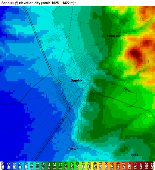
Below is the Elevation map of Sandıklı, which displays elevation range with different colors. Scale of the first map is from 1025 to 1422 m (3363 to 4665 ft) with average elevation of 1121.5 meters (=3679 ft) [note 1]
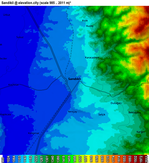
These maps also provides idea of topography and contour of this city, they are displayed at different zoom levels. More info about maps, scale and edge coordinates you can find below images.
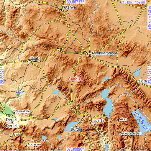
| \ | Map #1 | Map #2 | Topo.Map |
| Scale [m] | 1025..1422 m | 985..2011 m | × |
| Scale [ft] | 3363..4665 ft | 3232..6598 ft | × |
| Average | 1121.5 m = 3679 ft | 1176.9 m = 3861 ft | × |
| Width | 7.65 km = 4.8 mi | 15.3 km = 9.5 mi | 244.9 km = 152.2 mi |
| Height | 7.65 km = 4.8 mi | 15.3 km = 9.5 mi | 244.8 km = 152.1 mi |
| ↑Max Latitude | 38.499121° | 38.533505° | 39.55737° |
| Latitude at center | 38.46472° | 38.46472° | 38.46472° |
| ↓Min Latitude | 38.430303° | 38.39587° | 37.35526° |
| ← Min Longitude | 30.225515° | 30.181569° | 28.86321° |
| Longitude center | 30.26946° | 30.26946° | 30.26946° |
| →Max Longitude | 30.313405° | 30.357351° | 31.67571° |
Nearby cities:
Cities around Sandıklı sort by population:
• Afyonkarahisar elevation 1019 m
40.2 km,  36°
36°
• Dinar 863 m
45.4 km,  191°
191°
• Şuhut 1138 m
25.2 km,  72°
72°
• Uluborlu 1050 m
45.8 km,  159°
159°
• Sinanpaşa 1121 m
31.2 km,  355°
355°
• Hocalar 1075 m
29.1 km,  295°
295°
• Kızılören 1111 m
25.2 km,  204°
204°
• İshaklı 823 m
37 km,  217°
217°
• Homa 916 m
35.2 km, 224°
• Dombay 1038 m
34.9 km, 188°
• Haydarlı 1174 m
24.9 km, 156°
• Karadirek 1009 m
13.7 km,  327°
327°
Multilingual:
 En español:
Sandıklı elevación 1086 m.
 En France:
Sandıklı élévation 1086 m.
 Auf Deutsch:
Sandıklı höhe über dem Meeresspiegel ist 1086 m.

Sources and notes:
- [note 1] Map square and city borders are not equal. Map elevation data is calculated only from area inside that square.
- [src 1] Elevation data from geonames database provided with same terms of usage.
- [src 2] The elevation map of Sandıklı is generated using elevation data from NASA's 3 arcsec (90m) resolution SRTM data.
- [src 3] Base (background) map © OpenStreetMap contributors tiles are generated by Geofabrik and OpenTopoMap.
Copyright & License:
This Sandıklı Elevation Map is licensed under CC BY-SA. You may reuse any part from this page, if you give a proper credit by linking to this URL:
 More info on terms of use page.