Şereflikoçhisar elevation
Şereflikoçhisar (Ankara), Turkey elevation is 948 meters and Şereflikoçhisar elevation in feet is 3110 ft above sea level [src 1]. Şereflikoçhisar is a populated place (feature code) with elevation that is 225 meters (738 ft) bigger than average city elevation in Turkey.
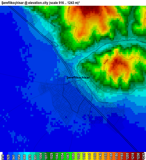
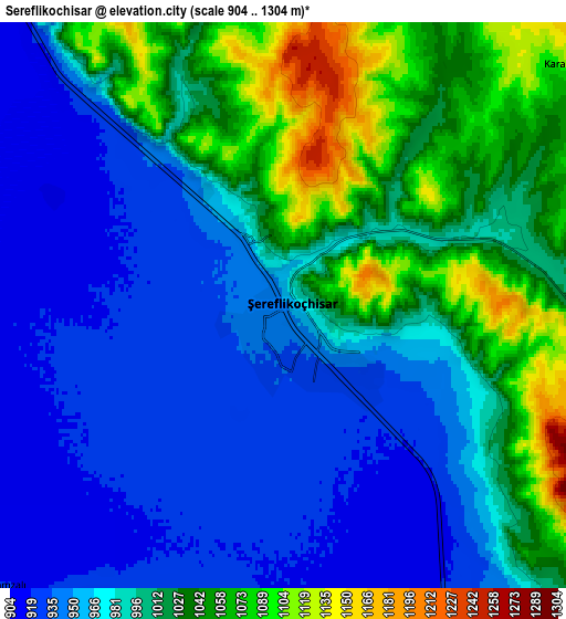
Below is the Elevation map of Şereflikoçhisar, which displays elevation range with different colors. Scale of the first map is from 916 to 1243 m (3005 to 4078 ft) with average elevation of 977 meters (=3205 ft) [note 1]
These maps also provides idea of topography and contour of this city, they are displayed at different zoom levels. More info about maps, scale and edge coordinates you can find below images.
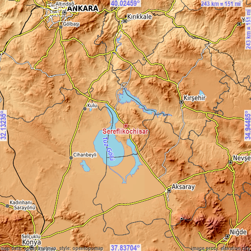
| \ | Map #1 | Map #2 | Topo.Map |
| Scale [m] | 916..1243 m | 904..1304 m | × |
| Scale [ft] | 3005..4078 ft | 2966..4278 ft | × |
| Average | 977 m = 3205 ft | 992.2 m = 3255 ft | × |
| Width | 7.6 km = 4.7 mi | 15.2 km = 9.4 mi | 243.2 km = 151.1 mi |
| Height | 7.6 km = 4.7 mi | 15.2 km = 9.4 mi | 243.2 km = 151.1 mi |
| ↑Max Latitude | 38.973423° | 39.007579° | 40.02459° |
| Latitude at center | 38.93925° | 38.93925° | 38.93925° |
| ↓Min Latitude | 38.905061° | 38.870855° | 37.83704° |
| ← Min Longitude | 33.494655° | 33.450709° | 32.13235° |
| Longitude center | 33.5386° | 33.5386° | 33.5386° |
| →Max Longitude | 33.582545° | 33.626491° | 34.94485° |
Nearby cities:
Cities around Şereflikoçhisar sort by population:
• Kırşehir elevation 997 m
58.7 km,  66°
66°
• Kulu 983 m
43.3 km,  293°
293°
• Ortaköy 1226 m
48.8 km,  117°
117°
• Kaman 1126 m
49.2 km,  18°
18°
• Sarıyahşi 971 m
26.6 km,  79°
79°
• Ağaçören 1232 m
33.5 km,  102°
102°
• Eskil 939 m
60.8 km,  190°
190°
• Çelebi 1247 m
58.4 km,  358°
358°
• Balcı 1160 m
54.2 km, 116°
• Acıpınar 993 m
53.3 km,  149°
149°
• Savcılı 932 m
34.5 km, 20°
• Evren 895 m
25 km, 67°
Multilingual:
 En español:
Şereflikoçhisar elevación 948 m.
 En France:
Şereflikoçhisar élévation 948 m.
 Auf Deutsch:
Şereflikoçhisar höhe über dem Meeresspiegel ist 948 m.

Sources and notes:
- [note 1] Map square and city borders are not equal. Map elevation data is calculated only from area inside that square.
- [src 1] Elevation data from geonames database provided with same terms of usage.
- [src 2] The elevation map of Şereflikoçhisar is generated using elevation data from NASA's 3 arcsec (90m) resolution SRTM data.
- [src 3] Base (background) map © OpenStreetMap contributors tiles are generated by Geofabrik and OpenTopoMap.
Copyright & License:
This Şereflikoçhisar Elevation Map is licensed under CC BY-SA. You may reuse any part from this page, if you give a proper credit by linking to this URL:
 More info on terms of use page.