Yeşilüzümlü elevation
Yeşilüzümlü (Muğla), Turkey elevation is 505 meters and Yeşilüzümlü elevation in feet is 1657 ft above sea level [src 1]. Yeşilüzümlü is a seat of a third-order administrative division (feature code) with elevation that is 218 meters (715 ft) smaller than average city elevation in Turkey.
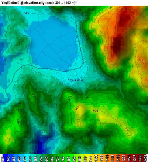
Below is the Elevation map of Yeşilüzümlü, which displays elevation range with different colors. Scale of the first map is from 301 to 1402 m (988 to 4600 ft) with average elevation of 685 meters (=2247 ft) [note 1]
These maps also provides idea of topography and contour of this city, they are displayed at different zoom levels. More info about maps, scale and edge coordinates you can find below images.
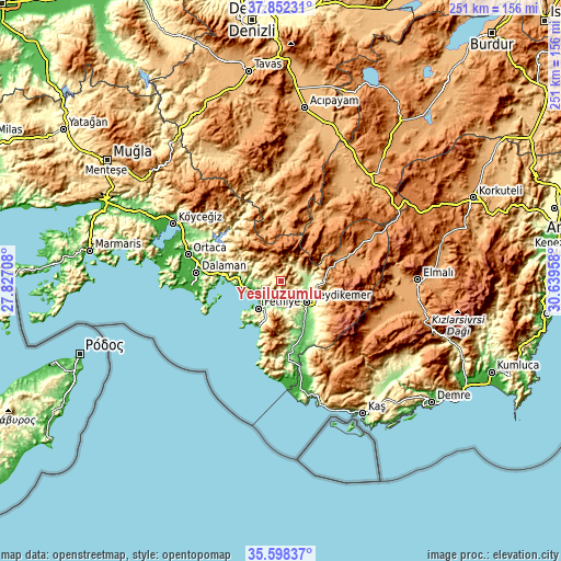
| \ | Map #1 | Topo.Map |
| Scale [m] | 301..1402 m | × |
| Scale [ft] | 988..4600 ft | × |
| Average | 685 m = 2247 ft | × |
| Width | 7.83 km = 4.9 mi | 250.6 km = 155.7 mi |
| Height | 7.83 km = 4.9 mi | 250.6 km = 155.7 mi |
| ↑Max Latitude | 36.768821° | 37.85231° |
| Latitude at center | 36.73361° | 36.73361° |
| ↓Min Latitude | 36.698383° | 35.59837° |
| ← Min Longitude | 29.189385° | 27.82708° |
| Longitude center | 29.23333° | 29.23333° |
| →Max Longitude | 29.277275° | 30.63958° |
Nearby cities:
Cities around Yeşilüzümlü sort by population:
• Fethiye elevation 9 m
14 km,  222°
222°
• Dalaman 16 m
38.5 km,  275°
275°
• Göcek 7 m
25.7 km,  274°
274°
• Altınyayla 1239 m
40.4 km,  43°
43°
• Ölüdeniz 353 m
20.2 km,  203°
203°
• Yaniklar 21 m
16.5 km,  260°
260°
• Kargı 21 m
14.5 km, 255°
• Çameli 1311 m
39.3 km,  14°
14°
• Kızılyaka 1213 m
38.2 km, 43°
• Seki 1172 m
38.1 km,  78°
78°
• Eşen 118 m
31.3 km,  172°
172°
• Kemer 141 m
14.7 km,  130°
130°
Multilingual:
 En español:
Yeşilüzümlü elevación 505 m.
 En France:
Yeşilüzümlü élévation 505 m.
 Auf Deutsch:
Yeşilüzümlü höhe über dem Meeresspiegel ist 505 m.

Sources and notes:
- [note 1] Map square and city borders are not equal. Map elevation data is calculated only from area inside that square.
- [src 1] Elevation data from geonames database provided with same terms of usage.
- [src 2] The elevation map of Yeşilüzümlü is generated using elevation data from NASA's 3 arcsec (90m) resolution SRTM data.
- [src 3] Base (background) map © OpenStreetMap contributors tiles are generated by Geofabrik and OpenTopoMap.
Copyright & License:
This Yeşilüzümlü Elevation Map is licensed under CC BY-SA. You may reuse any part from this page, if you give a proper credit by linking to this URL:
 More info on terms of use page.