Yavuzeli elevation
Yavuzeli (Gaziantep), Turkey elevation is 565 meters and Yavuzeli elevation in feet is 1854 ft above sea level [src 1]. Yavuzeli is a seat of a second-order administrative division (feature code) with elevation that is 158 meters (518 ft) smaller than average city elevation in Turkey.
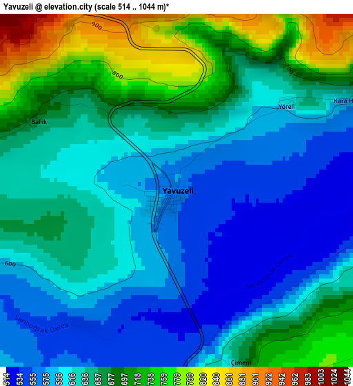
Below is the Elevation map of Yavuzeli, which displays elevation range with different colors. Scale of the first map is from 514 to 1044 m (1686 to 3425 ft) with average elevation of 641.7 meters (=2105 ft) [note 1]
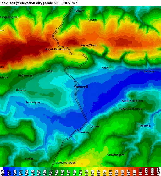
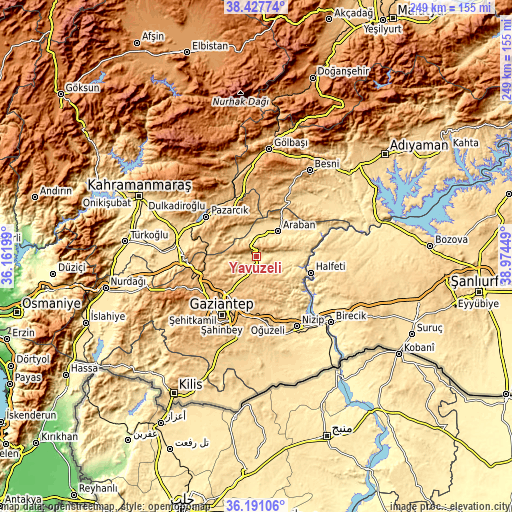
These maps also provides idea of topography and contour of this city, they are displayed at different zoom levels. More info about maps, scale and edge coordinates you can find below images.
| \ | Map #1 | Map #2 | Topo.Map |
| Scale [m] | 514..1044 m | 505..1077 m | × |
| Scale [ft] | 1686..3425 ft | 1657..3533 ft | × |
| Average | 641.7 m = 2105 ft | 721.1 m = 2366 ft | × |
| Width | 7.77 km = 4.8 mi | 15.54 km = 9.7 mi | 248.7 km = 154.5 mi |
| Height | 7.77 km = 4.8 mi | 15.54 km = 9.7 mi | 248.7 km = 154.5 mi |
| ↑Max Latitude | 37.352661° | 37.387586° | 38.42774° |
| Latitude at center | 37.31772° | 37.31772° | 37.31772° |
| ↓Min Latitude | 37.282763° | 37.247789° | 36.19106° |
| ← Min Longitude | 37.524295° | 37.480349° | 36.16199° |
| Longitude center | 37.56824° | 37.56824° | 37.56824° |
| →Max Longitude | 37.612185° | 37.656131° | 38.97449° |
Nearby cities:
Cities around Yavuzeli sort by population:
• Gaziantep elevation 842 m
33.1 km,  209°
209°
• Pazarcık 787 m
30.3 km,  308°
308°
• Araban 527 m
16.1 km,  41°
41°
• Halfeti 393 m
27.8 km,  106°
106°
• Yeşildere 709 m
38.9 km,  189°
189°
• Sekili 602 m
38.8 km,  166°
166°
• Narlı 588 m
39.1 km,  282°
282°
• Keysun 603 m
37.1 km, 43°
• Şahinbey 883 m
36 km, 213°
• Belören 990 m
35.5 km,  1°
1°
• Şehitkamil 860 m
31.3 km, 212°
• Suvarlı 979 m
25.2 km,  12°
12°
Multilingual:
 En español:
Yavuzeli elevación 565 m.
 En France:
Yavuzeli élévation 565 m.
 Auf Deutsch:
Yavuzeli höhe über dem Meeresspiegel ist 565 m.

Sources and notes:
- [note 1] Map square and city borders are not equal. Map elevation data is calculated only from area inside that square.
- [src 1] Elevation data from geonames database provided with same terms of usage.
- [src 2] The elevation map of Yavuzeli is generated using elevation data from NASA's 3 arcsec (90m) resolution SRTM data.
- [src 3] Base (background) map © OpenStreetMap contributors tiles are generated by Geofabrik and OpenTopoMap.
Copyright & License:
This Yavuzeli Elevation Map is licensed under CC BY-SA. You may reuse any part from this page, if you give a proper credit by linking to this URL:
 More info on terms of use page.