Kamışlı elevation
Kamışlı (Adana), Turkey elevation is 1141 meters and Kamışlı elevation in feet is 3743 ft above sea level [src 1]. Kamışlı is a seat of a third-order administrative division (feature code) with elevation that is 418 meters (1371 ft) bigger than average city elevation in Turkey.
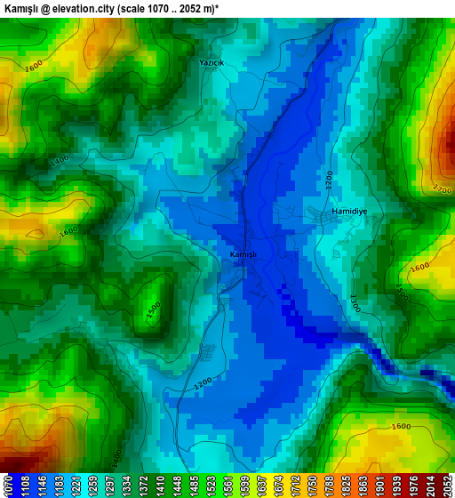
Below is the Elevation map of Kamışlı, which displays elevation range with different colors. Scale of the first map is from 1070 to 2052 m (3510 to 6732 ft) with average elevation of 1358 meters (=4455 ft) [note 1]
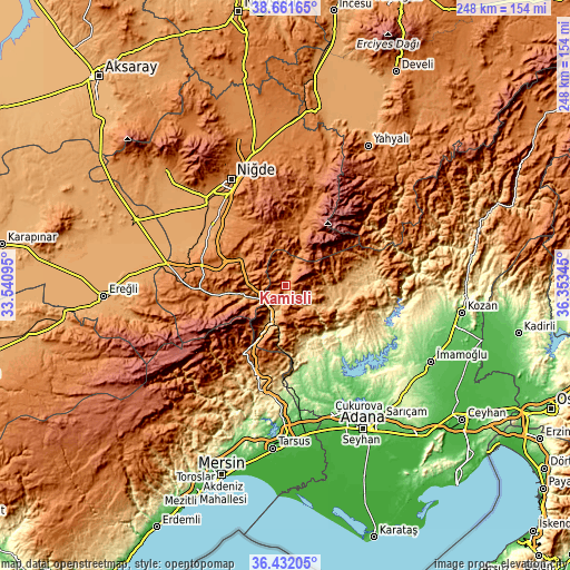
These maps also provides idea of topography and contour of this city, they are displayed at different zoom levels. More info about maps, scale and edge coordinates you can find below images.
| \ | Map #1 | Topo.Map |
| Scale [m] | 1070..2052 m | × |
| Scale [ft] | 3510..6732 ft | × |
| Average | 1358 m = 4455 ft | × |
| Width | 7.75 km = 4.8 mi | 247.9 km = 154 mi |
| Height | 7.75 km = 4.8 mi | 247.9 km = 154 mi |
| ↑Max Latitude | 37.59002° | 38.66165° |
| Latitude at center | 37.55519° | 37.55519° |
| ↓Min Latitude | 37.520343° | 36.43205° |
| ← Min Longitude | 34.903255° | 33.54095° |
| Longitude center | 34.9472° | 34.9472° |
| →Max Longitude | 34.991145° | 36.35345° |
Nearby cities:
Cities around Kamışlı sort by population:
• Niğde elevation 1243 m
51.4 km,  332°
332°
• Bor 1116 m
50.6 km,  317°
317°
• Pozantı 827 m
15.7 km,  205°
205°
• Aladağ 896 m
39.6 km,  91°
91°
• Karaisalı 271 m
34.6 km,  163°
163°
• Tepecikören 172 m
63.7 km,  109°
109°
• Çamlıyayla 1149 m
53.4 km,  215°
215°
• Çatalan 147 m
45.7 km,  138°
138°
• Kemerhisar 1110 m
44.6 km,  312°
312°
• Ulukışla 1435 m
40.7 km,  268°
268°
• Çamardı 1482 m
30.9 km,  5°
5°
• Çiftehan 978 m
16.4 km,  253°
253°
Multilingual:
 En español:
Kamışlı elevación 1141 m.
 En France:
Kamışlı élévation 1141 m.
 Auf Deutsch:
Kamışlı höhe über dem Meeresspiegel ist 1141 m.

Sources and notes:
- [note 1] Map square and city borders are not equal. Map elevation data is calculated only from area inside that square.
- [src 1] Elevation data from geonames database provided with same terms of usage.
- [src 2] The elevation map of Kamışlı is generated using elevation data from NASA's 3 arcsec (90m) resolution SRTM data.
- [src 3] Base (background) map © OpenStreetMap contributors tiles are generated by Geofabrik and OpenTopoMap.
Copyright & License:
This Kamışlı Elevation Map is licensed under CC BY-SA. You may reuse any part from this page, if you give a proper credit by linking to this URL:
 More info on terms of use page.