Kairouan elevation
Kairouan, Tunisia elevation is 65 meters and Kairouan elevation in feet is 213 ft above sea level [src 1]. Kairouan is a seat of a first-order administrative division (feature code) with elevation that is 84 meters (276 ft) smaller than average city elevation in Tunisia.
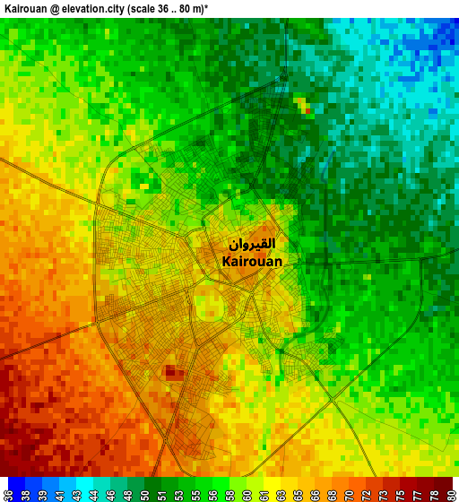
Below is the Elevation map of Kairouan, which displays elevation range with different colors. Scale of the first map is from 36 to 80 m (118 to 262 ft) with average elevation of 58.6 meters (=192 ft) [note 1]
These maps also provides idea of topography and contour of this city, they are displayed at different zoom levels. More info about maps, scale and edge coordinates you can find below images.
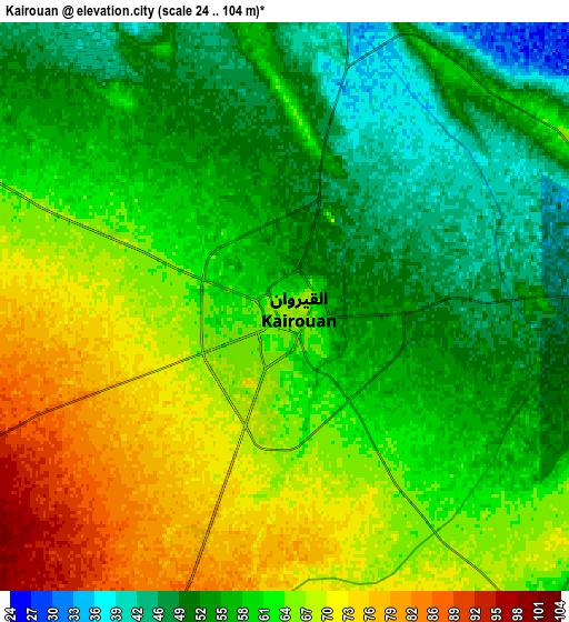
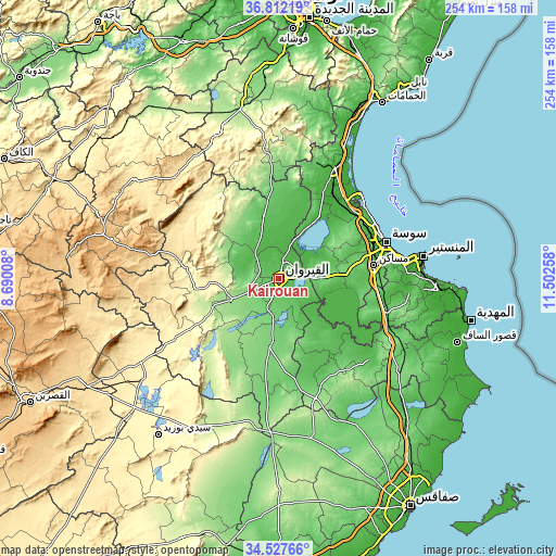
| \ | Map #1 | Map #2 | Topo.Map |
| Scale [m] | 36..80 m | 24..104 m | × |
| Scale [ft] | 118..262 ft | 79..341 ft | × |
| Average | 58.6 m = 192 ft | 60.3 m = 198 ft | × |
| Width | 7.94 km = 4.9 mi | 15.88 km = 9.9 mi | 254 km = 157.8 mi |
| Height | 7.94 km = 4.9 mi | 15.88 km = 9.9 mi | 254 km = 157.8 mi |
| ↑Max Latitude | 35.713789° | 35.749462° | 36.81219° |
| Latitude at center | 35.6781° | 35.6781° | 35.6781° |
| ↓Min Latitude | 35.642395° | 35.606674° | 34.52766° |
| ← Min Longitude | 10.052385° | 10.008439° | 8.69008° |
| Longitude center | 10.09633° | 10.09633° | 10.09633° |
| →Max Longitude | 10.140275° | 10.184221° | 11.50258° |
Nearby cities:
Cities around Kairouan sort by population:
• Sousse elevation 24 m
51.5 km,  71°
71°
• Msaken 47 m
44.1 km,  82°
82°
• Hammam Sousse 10 m
50 km, 66°
• Akouda 33 m
47.3 km,  63°
63°
• Ouardenine 63 m
52.3 km,  86°
86°
• Sidi Bou Ali 19 m
46 km,  47°
47°
• Menzel Kamel 48 m
51.9 km,  96°
96°
• Haffouz 284 m
38.3 km,  262°
262°
• Sbikha 66 m
29.2 km,  346°
346°
• Chorbane 110 m
50.9 km,  148°
148°
• Port el Kantaoui 8 m
50.8 km, 62°
• Sidi el Hani 87 m
19.8 km, 92°
Multilingual:
 En español:
Kairuán elevación 65 m.
 En France:
Kairouan élévation 65 m.


Sources and notes:
- [note 1] Map square and city borders are not equal. Map elevation data is calculated only from area inside that square.
- [src 1] Elevation data from geonames database provided with same terms of usage.
- [src 2] The elevation map of Kairouan is generated using elevation data from NASA's 3 arcsec (90m) resolution SRTM data.
- [src 3] Base (background) map © OpenStreetMap contributors tiles are generated by Geofabrik and OpenTopoMap.
Copyright & License:
This Kairouan Elevation Map is licensed under CC BY-SA. You may reuse any part from this page, if you give a proper credit by linking to this URL:
 More info on terms of use page.